TopoQuest Logo
Do you find TopoQuest useful?
Help keep TopoQuest running and adding new maps/features by donating!
Bitcoin:  19c7KJd3qBynnjoSw5npx9KScwjBe4ifkT
Litecoin:  LXs6TkuXGGXo1vDsWCkWVdjQX94eUKd6ui
Home View Maps Find Maps Find Places Resources & Links


Blanco Mountain, California Topographic Map

USGS Map Title: Blanco Mountain, CA
USGS Map MRC: 37118D2
DRG (GeoTIFF) Download: o37118d2.tif


Neighboring USGS Topographic Map Quads:


  Chalfant Valley, CA  
37118E3
 

  Mount Barcroft, CA  
37118E2
 

  Station Peak, CA  
37118E1
 

  Laws, CA  
37118D3
 

  Blanco Mountain, CA  
37118D2
 

  Crooked Creek, CA  
37118D1
 

  Poleta Canyon, CA  
37118C3
 

  Westgard Pass, CA  
37118C2
 

  Deep Springs Lake, CA  
37118C1


Map MRC Location:

N38°
W119°
N38°
W118°
H8 H7 H6 H5 H4 H3 H2 H1
G8 G7 G6 G5 G4 G3 G2 G1
F8 F7 F6 F5 F4 F3 F2 F1
E8 E7 E6 E5 E4 E3 E2 E1
D8 D7 D6 D5 D4 D3 D2 D1
C8 C7 C6 C5 C4 C3 C2 C1
B8 B7 B6 B5 B4 B3 B2 B1
A8 A7 A6 A5 A4 A3 A2 A1
N37°
W119°
N37°
W118°

Blanco Mountain, CA USGS 1:24K Topographic Map Preview:
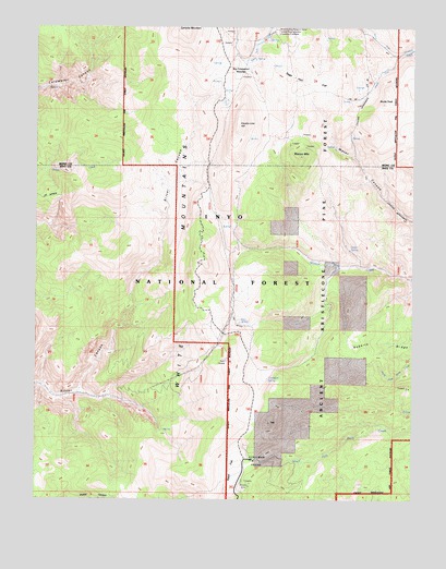
Blanco Mountain, CA USGS Topographic Map
Click on map above to begin viewing in our Map Viewer.

This topographic map contains these locations and features:
Feature Name Type Latitude Longitude GNIS ID View Map
Ancient Bristlecone Pine ForestForestN37.4488°W118.1426°1667266View Map
Big Prospector MeadowFlatN37.4913°W118.1845°256988View Map
Blanco MountainSummitN37.4655°W118.1626°257199View Map
Bristlecone Visitor CenterBuildingN37.3853°W118.1783°2547605View Map
Bucks PeakSummitN37.4749°W118.1409°257640View Map
Camp BristleconeLocaleN37.4991°W118.1734°275645View Map
Campito MountainSummitN37.4985°W118.2012°266529View Map
Cedar SpringSpringN37.4413°W118.1462°258148View Map
Clem Nelson PeakSummitN37.3957°W118.1732°2740411View Map
Coldwater SpringSpringN37.4072°W118.1745°258581View Map
County Line HillSummitN37.4722°W118.1845°258783View Map
Discovery TrailTrailN37.3872°W118.1793°275646View Map
Goat SpringSpringN37.4216°W118.1826°260626View Map
KIBS-FM (Bishop)TowerN37.4166°W118.1843°1665009View Map
Methuselah TrailTrailN37.3794°W118.1618°275649View Map
Mexican MineMineN37.3797°W118.1807°263477View Map
North Fork Crooked CreekStreamN37.4927°W118.1301°264154View Map
Reed FlatFlatN37.3819°W118.1873°265359View Map
Sage Hen FlatFlatN37.4885°W118.1645°265721View Map
Schulman GroveWoodsN37.3855°W118.1770°1667250View Map
Schulman Grove Picnic AreaLocaleN37.3852°W118.1779°275648View Map
Schulman Grove Picnic SiteLocaleN37.3856°W118.1786°2547700View Map
Schulman Grove Visitor CenterBuildingN37.3855°W118.1784°1804600View Map
Schulman-Methusalah TrailheadLocaleN37.3853°W118.1784°2547701View Map
See RemarksLocaleN37.4991°W118.1712°275647View Map
South Fork Crooked CreekStreamN37.4927°W118.1301°267447View Map
White Mountain Research StationLocaleN37.4994°W118.1715°1667384View Map

Note: Coordinates in the location and feature list above are referenced to NAD83 datum.


Copyright (C) 2008-2024 Ryan Niemi / Sunset Dynamics ... All Rights Reserved