TopoQuest Logo
Do you find TopoQuest useful?
Help keep TopoQuest running and adding new maps/features by donating!
Bitcoin:  19c7KJd3qBynnjoSw5npx9KScwjBe4ifkT
Litecoin:  LXs6TkuXGGXo1vDsWCkWVdjQX94eUKd6ui
Home View Maps Find Maps Find Places Resources & Links


Sutherland East, Iowa Topographic Map

USGS Map Title: Sutherland East, IA
USGS Map MRC: 42095H4
DRG (GeoTIFF) Download: o42095h4.tif


Neighboring USGS Topographic Map Quads:


  Gaza, IA  
43095A5
 

  Hartley SW, IA  
43095A4
 

  Royal, IA  
43095A3
 

  Sutherland West, IA  
42095H5
 

  Sutherland East, IA  
42095H4
 

  Peterson, IA  
42095H3
 

  Cherokee North, IA  
42095G5
 

  Peterson SW, IA  
42095G4
 

  Peterson SE, IA  
42095G3


Map MRC Location:

N43°
W96°
N43°
W95°
H8 H7 H6 H5 H4 H3 H2 H1
G8 G7 G6 G5 G4 G3 G2 G1
F8 F7 F6 F5 F4 F3 F2 F1
E8 E7 E6 E5 E4 E3 E2 E1
D8 D7 D6 D5 D4 D3 D2 D1
C8 C7 C6 C5 C4 C3 C2 C1
B8 B7 B6 B5 B4 B3 B2 B1
A8 A7 A6 A5 A4 A3 A2 A1
N42°
W96°
N42°
W95°

Sutherland East, IA USGS 1:24K Topographic Map Preview:
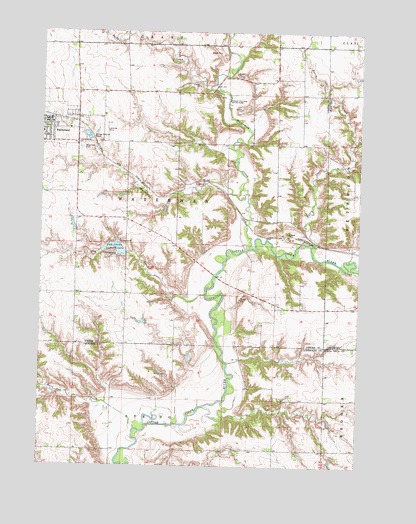
Sutherland East, IA USGS Topographic Map
Click on map above to begin viewing in our Map Viewer.

This topographic map contains these locations and features:
Feature Name Type Latitude Longitude GNIS ID View Map
Bethel Lutheran ChurchChurchN42.9694°W95.4992°1907048View Map
Calvary CemeteryCemeteryN42.9685°W95.4859°455079View Map
Camp Yo-Lo-To-GoLocaleN42.9828°W95.4308°1907055View Map
City of SutherlandCivilN42.9728°W95.4950°2396011View Map
Dog CreekStreamN42.9241°W95.4358°455942View Map
Dog Creek County ParkParkN42.9366°W95.4728°455943View Map
Dog Creek DamDamN42.9366°W95.4672°467202View Map
First CemeteryCemeteryN42.9333°W95.4169°1907056View Map
First Settlement in O'Brien County Historical MarkerParkN42.9305°W95.4169°1907040View Map
Fred Fieldman GraveCemeteryN42.9444°W95.3975°1907057View Map
General N B Baker LibraryBuildingN42.9719°W95.4997°1907044View Map
Henry CreekStreamN42.9389°W95.3933°457400View Map
Hill Little Sioux OverlookLocaleN42.9436°W95.3989°1906988View Map
Indian Village State ParkParkN42.9789°W95.4269°457807View Map
Jordan CreekStreamN42.9850°W95.4328°457997View Map
Jurgensen FarmsLocaleN42.9689°W95.4594°2725379View Map
Lenhart DairyLocaleN42.9833°W95.4514°2725380View Map
McCormack AreaParkN42.9633°W95.4267°1906987View Map
Millies Rest HomeHospitalN42.9719°W95.4895°1907145View Map
Murray CreekStreamN42.9528°W95.4236°459413View Map
Negus Recreation AreaParkN42.9375°W95.4872°1906985View Map
O'BrienLocaleN42.9208°W95.4031°465960View Map
O'Brien Post Office (historical)Post OfficeN42.9166°W95.4058°1906993View Map
Old Dutch Fred AccessLocaleN42.9241°W95.4364°1906986View Map
Sacred Heart Catholic ChurchChurchN42.9700°W95.4995°1907047View Map
Soo River AccessLocaleN42.8764°W95.4669°1907147View Map
SutherlandPopulated PlaceN42.9741°W95.4975°462123View Map
Sutherland (historical)LocaleN42.9750°W95.4981°1907052View Map
Sutherland Family Medicine CenterHospitalN42.9741°W95.4983°1907045View Map
Sutherland Farmers Co-op ElevatorLocaleN42.9911°W95.4958°1907043View Map
Sutherland Fire Rescue and AmbulanceBuildingN42.9742°W95.4957°2577503View Map
Sutherland Post OfficePost OfficeN42.9744°W95.4981°1907042View Map
Township of WatermanCivilN42.9530°W95.4466°468952View Map
WatermanPopulated PlaceN42.9558°W95.4447°464065View Map
Waterman CemeteryCemeteryN42.9664°W95.4850°462732View Map
Waterman CreekStreamN42.9383°W95.4181°462733View Map
Waterman Post Office (historical)Post OfficeN42.9558°W95.4447°1906989View Map
Waterman Prairie Wildlife Management AreaParkN42.9583°W95.4169°1906984View Map
Wurth Chiropractic ClinicHospitalN42.9711°W95.4995°1907046View Map

Note: Coordinates in the location and feature list above are referenced to NAD83 datum.


Copyright (C) 2008-2024 Ryan Niemi / Sunset Dynamics ... All Rights Reserved