TopoQuest Logo
Do you find TopoQuest useful?
Help keep TopoQuest running and adding new maps/features by donating!
Bitcoin:  19c7KJd3qBynnjoSw5npx9KScwjBe4ifkT
Litecoin:  LXs6TkuXGGXo1vDsWCkWVdjQX94eUKd6ui
Home View Maps Find Maps Find Places Resources & Links


Swan Lake, Montana Topographic Map

USGS Map Title: Swan Lake, MT
USGS Map MRC: 47113H7
DRG (GeoTIFF) Download: o47113h7.tif


Neighboring USGS Topographic Map Quads:


  Crater Lake, MT  
48113A8
 

  Big Hawk Mountain, MT  
48113A7
 

  Quintonkon, MT  
48113A6
 

  Yew Creek, MT  
47113H8
 

  Swan Lake, MT  
47113H7
 

  Connor Creek, MT  
47113H6
 

  Porcupine Creek, MT  
47113G8
 

  Cilly Creek, MT  
47113G7
 

  Thunderbolt Mountain, MT  
47113G6


Map MRC Location:

N48°
W114°
N48°
W113°
H8 H7 H6 H5 H4 H3 H2 H1
G8 G7 G6 G5 G4 G3 G2 G1
F8 F7 F6 F5 F4 F3 F2 F1
E8 E7 E6 E5 E4 E3 E2 E1
D8 D7 D6 D5 D4 D3 D2 D1
C8 C7 C6 C5 C4 C3 C2 C1
B8 B7 B6 B5 B4 B3 B2 B1
A8 A7 A6 A5 A4 A3 A2 A1
N47°
W114°
N47°
W113°

Swan Lake, MT USGS 1:24K Topographic Map Preview:
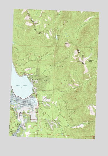
Swan Lake, MT USGS Topographic Map
Click on map above to begin viewing in our Map Viewer.

This topographic map contains these locations and features:
Feature Name Type Latitude Longitude GNIS ID View Map
25N18W13CDDC01 WellWellN47.9213°W113.8268°825210View Map
25N18W14DBB_01 WellWellN47.9274°W113.8451°825217View Map
25N18W35ADDA01 WellWellN47.8866°W113.8362°825159View Map
25N18W35DBCB01 WellWellN47.8830°W113.8432°825152View Map
Bond CreekStreamN47.9219°W113.8440°780210View Map
Con Kelley MountainSummitN47.9511°W113.7748°781554View Map
Gildart (historical)LocaleN47.9036°W113.8743°1796912View Map
Gildart CreekStreamN47.8863°W113.8609°783936View Map
Groom CreekStreamN47.9299°W113.8484°784362View Map
Hall CreekStreamN47.9330°W113.8518°784481View Map
Hall LakeLakeN47.9735°W113.8120°784486View Map
Hall PeakSummitN47.9686°W113.7948°784487View Map
Mission LookoutLocaleN47.8941°W113.8740°787500View Map
Sixmile MountainSummitN47.9863°W113.8443°790566View Map
Spring CreekStreamN47.9155°W113.8468°791225View Map
Swan ChapelChurchN47.9291°W113.8448°1796895View Map
Swan LakePopulated PlaceN47.9291°W113.8448°791786View Map
Swan Lake CampgroundLocaleN47.9366°W113.8515°799060View Map
Swan Lake Census Designated PlaceCensusN47.9361°W113.7997°2583855View Map
Swan Lake Guard StationLocaleN47.9088°W113.8343°799026View Map
Swan Lake Picnic SiteLocaleN47.9361°W113.8545°799059View Map
Swan Lake Post Office (historical)Post OfficeN47.9297°W113.8379°1796817View Map
Swan Lake Public LibraryBuildingN47.9291°W113.8448°1797008View Map
Swan Lake SchoolSchoolN47.9361°W113.8370°1796856View Map
Swan Lake Volunteer Fire DepartmentBuildingN47.9237°W113.8416°1796801View Map
Swan River National Wildlife RefugeParkN47.9071°W113.8591°794348View Map
Wire TrailTrailN47.9094°W113.7745°793429View Map

Note: Coordinates in the location and feature list above are referenced to NAD83 datum.


Copyright (C) 2008-2024 Ryan Niemi / Sunset Dynamics ... All Rights Reserved