TopoQuest Logo
Do you find TopoQuest useful?
Help keep TopoQuest running and adding new maps/features by donating!
Bitcoin:  19c7KJd3qBynnjoSw5npx9KScwjBe4ifkT
Litecoin:  LXs6TkuXGGXo1vDsWCkWVdjQX94eUKd6ui
Home View Maps Find Maps Find Places Resources & Links


Quintonkon, Montana Topographic Map

USGS Map Title: Quintonkon, MT
USGS Map MRC: 48113A6
DRG (GeoTIFF) Download: o48113a6.tif


Neighboring USGS Topographic Map Quads:


  Pioneer Ridge, MT  
48113B7
 

  Felix Peak, MT  
48113B6
 

  Nimrod, MT  
48113B5
 

  Big Hawk Mountain, MT  
48113A7
 

  Quintonkon, MT  
48113A6
 

  Circus Peak, MT  
48113A5
 

  Swan Lake, MT  
47113H7
 

  Connor Creek, MT  
47113H6
 

  Tin Creek, MT  
47113H5


Map MRC Location:

N49°
W114°
N49°
W113°
H8 H7 H6 H5 H4 H3 H2 H1
G8 G7 G6 G5 G4 G3 G2 G1
F8 F7 F6 F5 F4 F3 F2 F1
E8 E7 E6 E5 E4 E3 E2 E1
D8 D7 D6 D5 D4 D3 D2 D1
C8 C7 C6 C5 C4 C3 C2 C1
B8 B7 B6 B5 B4 B3 B2 B1
A8 A7 A6 A5 A4 A3 A2 A1
N48°
W114°
N48°
W113°

Quintonkon, MT USGS 1:24K Topographic Map Preview:
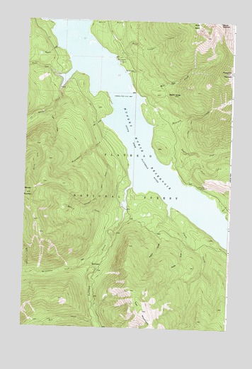
Quintonkon, MT USGS Topographic Map
Click on map above to begin viewing in our Map Viewer.

This topographic map contains these locations and features:
Feature Name Type Latitude Longitude GNIS ID View Map
Ball CreekStreamN48.0027°W113.7045°779311View Map
Baptiste CreekStreamN48.0827°W113.6726°779335View Map
Baptiste GraveCemeteryN48.1005°W113.6634°779336View Map
Baptiste SpringsSpringN48.0947°W113.6633°794229View Map
Battery CreekStreamN48.0494°W113.6898°779436View Map
Battery MountainSummitN48.0544°W113.7490°779437View Map
Battery Mountain TrailTrailN48.0533°W113.7062°779438View Map
Brush CreekStreamN48.0477°W113.6295°780487View Map
Clark CreekStreamN48.0463°W113.6615°781317View Map
Czar CreekStreamN48.0847°W113.7040°782028View Map
Deadhorse CreekStreamN48.0680°W113.6615°782150View Map
Devils Corkscrew CampgroundLocaleN48.1097°W113.6970°799040View Map
Devils Corkscrew CreekStreamN48.1111°W113.6973°782325View Map
Emperor CreekStreamN48.1136°W113.7329°783201View Map
Forest CreekStreamN48.1022°W113.7315°783598View Map
Heinrude CreekStreamN48.0819°W113.6998°784713View Map
Hoke CreekStreamN48.1041°W113.6893°784928View Map
Kah MountainSummitN48.0069°W113.6765°785619View Map
Lyon CreekStreamN48.0869°W113.7387°786740View Map
Peters CreekStreamN48.0586°W113.6506°788780View Map
Peters Creek CampgroundLocaleN48.0569°W113.6429°788781View Map
Peters Creek Sportsmans AccessLocaleN48.0555°W113.6409°798909View Map
Prospector MountainSummitN48.1047°W113.6270°789215View Map
Quintokon Forest Service StationLocaleN48.0263°W113.7073°798908View Map
QuintonkonPopulated PlaceN48.0263°W113.7070°789306View Map
Quintonkon CreekStreamN48.0258°W113.7079°789307View Map
Rock CreekStreamN48.0211°W113.7476°789681View Map
Sullivan CreekStreamN48.0580°W113.6851°791648View Map
Taylor CreekStreamN48.0383°W113.6529°791908View Map
Wheeler CreekStreamN48.0963°W113.7301°793158View Map

Note: Coordinates in the location and feature list above are referenced to NAD83 datum.


Copyright (C) 2008-2025 Ryan Niemi / Sunset Dynamics ... All Rights Reserved