TopoQuest Logo
Do you find TopoQuest useful?
Help keep TopoQuest running and adding new maps/features by donating!
Bitcoin:  19c7KJd3qBynnjoSw5npx9KScwjBe4ifkT
Litecoin:  LXs6TkuXGGXo1vDsWCkWVdjQX94eUKd6ui
Home View Maps Find Maps Find Places Resources & Links


Swanton, Nebraska Topographic Map

USGS Map Title: Swanton, NE
USGS Map MRC: 40097D1
DRG (GeoTIFF) Download: o40097d1.tif


Neighboring USGS Topographic Map Quads:


  Dorchester SW, NE  
40097E2
 

  Pleasant Hill, NE  
40097E1
 

  Crete South, NE  
40096E8
 

  Western, NE  
40097D2
 

  Swanton, NE  
40097D1
 

  Wilber, NE  
40096D8
 

  Western SW, NE  
40097C2
 

  Western SE, NE  
40097C1
 

  Plymouth, NE  
40096C8


Map MRC Location:

N41°
W98°
N41°
W97°
H8 H7 H6 H5 H4 H3 H2 H1
G8 G7 G6 G5 G4 G3 G2 G1
F8 F7 F6 F5 F4 F3 F2 F1
E8 E7 E6 E5 E4 E3 E2 E1
D8 D7 D6 D5 D4 D3 D2 D1
C8 C7 C6 C5 C4 C3 C2 C1
B8 B7 B6 B5 B4 B3 B2 B1
A8 A7 A6 A5 A4 A3 A2 A1
N40°
W98°
N40°
W97°

Swanton, NE USGS 1:24K Topographic Map Preview:
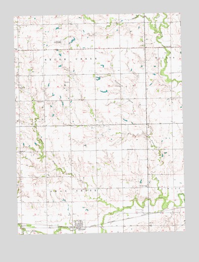
Swanton, NE USGS Topographic Map
Click on map above to begin viewing in our Map Viewer.

This topographic map contains these locations and features:
Feature Name Type Latitude Longitude GNIS ID View Map
Bethel SchoolSchoolN40.4808°W97.1231°827386View Map
Brush CreekStreamN40.4900°W97.0195°827714View Map
Brush Creek Election PrecinctCivilN40.4803°W97.0844°1928759View Map
Cline SchoolSchoolN40.4614°W97.0845°828214View Map
Davisson SchoolSchoolN40.4222°W97.0423°828601View Map
Dry CreekStreamN40.4889°W97.0159°828818View Map
Farmers Co-op ElevatorLocaleN40.3783°W97.0814°1882541View Map
Golden SchoolSchoolN40.4583°W97.0464°829559View Map
Green Valley SchoolSchoolN40.4808°W97.0084°829670View Map
Mumby SchoolSchoolN40.4225°W97.1228°831531View Map
North Fork Swan CreekStreamN40.3781°W97.1198°831699View Map
Pleasant Valley SchoolSchoolN40.3800°W97.1217°832234View Map
Plummers BranchStreamN40.3939°W97.0186°832284View Map
Plummers Branch CemeteryCemeteryN40.3867°W97.0317°832285View Map
Plummers Branch SchoolSchoolN40.4006°W97.0278°832286View Map
South Fork Swan CreekStreamN40.3781°W97.1198°833593View Map
Swan Creek Election PrecinctCivilN40.3932°W97.0843°1929328View Map
SwantonPopulated PlaceN40.3786°W97.0798°833983View Map
SwantonLocaleN40.3781°W97.0728°1882539View Map
Swanton City ParkParkN40.3792°W97.0803°1882538View Map
Swanton Post OfficePost OfficeN40.3790°W97.0799°1882542View Map
Swanton Volunteer Fire DepartmentBuildingN40.3789°W97.0787°1882540View Map
Township of Brush CreekCivilN40.4778°W97.0836°1882314View Map
Township of Swan CreekCivilN40.3917°W97.0836°1882311View Map
United Methodist ChurchChurchN40.3806°W97.0773°1882537View Map
Village of SwantonCivilN40.3796°W97.0798°2399941View Map
Walnut Grove CreekStreamN40.3872°W97.0514°834452View Map
Waymire CemeteryCemeteryN40.4508°W97.1039°1882467View Map
Waymire SchoolSchoolN40.4592°W97.1225°834512View Map

Note: Coordinates in the location and feature list above are referenced to NAD83 datum.


Copyright (C) 2008-2024 Ryan Niemi / Sunset Dynamics ... All Rights Reserved