TopoQuest Logo
Do you find TopoQuest useful?
Help keep TopoQuest running and adding new maps/features by donating!
Bitcoin:  19c7KJd3qBynnjoSw5npx9KScwjBe4ifkT
Litecoin:  LXs6TkuXGGXo1vDsWCkWVdjQX94eUKd6ui
Home View Maps Find Maps Find Places Resources & Links


Wilber, Nebraska Topographic Map

USGS Map Title: Wilber, NE
USGS Map MRC: 40096D8
DRG (GeoTIFF) Download: o40096d8.tif


Neighboring USGS Topographic Map Quads:


  Pleasant Hill, NE  
40097E1
 

  Crete South, NE  
40096E8
 

  Hallam, NE  
40096E7
 

  Swanton, NE  
40097D1
 

  Wilber, NE  
40096D8
 

  Clatonia, NE  
40096D7
 

  Western SE, NE  
40097C1
 

  Plymouth, NE  
40096C8
 

  Beatrice West, NE  
40096C7


Map MRC Location:

N41°
W97°
N41°
W96°
H8 H7 H6 H5 H4 H3 H2 H1
G8 G7 G6 G5 G4 G3 G2 G1
F8 F7 F6 F5 F4 F3 F2 F1
E8 E7 E6 E5 E4 E3 E2 E1
D8 D7 D6 D5 D4 D3 D2 D1
C8 C7 C6 C5 C4 C3 C2 C1
B8 B7 B6 B5 B4 B3 B2 B1
A8 A7 A6 A5 A4 A3 A2 A1
N40°
W97°
N40°
W96°

Wilber, NE USGS 1:24K Topographic Map Preview:
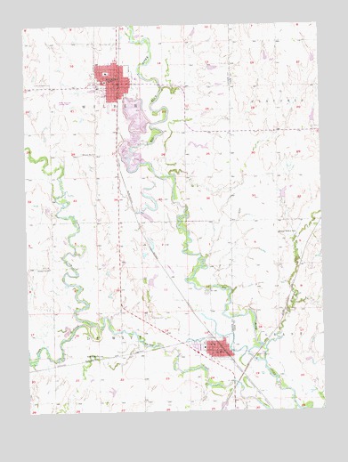
Wilber, NE USGS Topographic Map
Click on map above to begin viewing in our Map Viewer.

This topographic map contains these locations and features:
Feature Name Type Latitude Longitude GNIS ID View Map
Bergmeier Dam Number 2DamN40.4437°W96.8916°1768645View Map
Bergmeier Reservoir Number 2LakeN40.4452°W96.8914°1768646View Map
Cecho Slovansky CemeteryCemeteryN40.4811°W96.9867°827975View Map
Chris Petersen Ball FieldParkN40.3942°W96.9259°1882533View Map
City of WilberCivilN40.4809°W96.9646°2397309View Map
Clatonia CreekStreamN40.3900°W96.9009°828167View Map
Czech Capital Historical MarkerParkN40.4811°W96.9695°1882612View Map
Czech VillageLocaleN40.4811°W96.9695°1882611View Map
De WittPopulated PlaceN40.3936°W96.9228°828616View Map
De Witt Election PrecinctCivilN40.3931°W96.9705°1928809View Map
DeWittLocaleN40.3950°W96.9178°1882528View Map
DeWitt City ParkParkN40.3950°W96.9253°1882532View Map
DeWitt Post OfficePost OfficeN40.3948°W96.9200°1882527View Map
DeWitt Public LibraryBuildingN40.3953°W96.9203°1882535View Map
Dewitt Volunteer Fire and RescueBuildingN40.3947°W96.9188°1882536View Map
Dvoracek Memorial LibraryBuildingN40.4811°W96.9650°1882610View Map
Essman DamDamN40.3907°W96.8830°1768587View Map
Essman ReservoirReservoirN40.3912°W96.8815°1768588View Map
Farmers Co-op ElevatorLocaleN40.4819°W96.9595°1882593View Map
First Lutheran ChurchChurchN40.4822°W96.9639°1882601View Map
Germer Dam Number 1DamN40.4684°W96.8786°1768647View Map
Germer Reservoir Number 1LakeN40.4697°W96.8785°1768648View Map
Happy Hollow School (historical)SchoolN40.4306°W96.8934°829789View Map
Huneke DamDamN40.4863°W96.9221°1766835View Map
Huneke ReservoirReservoirN40.4861°W96.9206°1766836View Map
Legion Memorial ParkParkN40.4750°W96.9636°1882608View Map
Legion Memorial Park CampgroundLocaleN40.4750°W96.9636°1882609View Map
Memorial ParkParkN40.3950°W96.9200°1882534View Map
Oak Grove CemeteryCemeteryN40.4050°W96.9486°831809View Map
Roscoe Hill Hatchery DamDamN40.4400°W96.8903°1769952View Map
Roscoe Hill Hatchery ReservoirReservoirN40.4400°W96.8903°1769953View Map
Saint Augustine Episcopal ChurchChurchN40.3958°W96.9223°1882531View Map
Saint Wenceslas Catholic ChurchChurchN40.4881°W96.9617°1882600View Map
Saline County CourthouseBuildingN40.4819°W96.9659°1882605View Map
Saline County SheriffBuildingN40.4751°W96.9615°1882594View Map
Saline EldercareHospitalN40.4808°W96.9611°1882599View Map
School Number 5SchoolN40.4586°W96.9703°836803View Map
School Number 7SchoolN40.3922°W96.9711°837021View Map
School Number 93SchoolN40.4214°W96.9906°837202View Map
Schuerman DamDamN40.4295°W96.9213°1770168View Map
Schuerman ReservoirLakeN40.4302°W96.9203°1770169View Map
Sunny Side CemeteryCemeteryN40.4942°W96.9689°833909View Map
Swan City Historical MarkerParkN40.4083°W96.9592°1882615View Map
Swan CreekStreamN40.4019°W96.9706°833972View Map
Township of De WittCivilN40.3917°W96.9698°1882312View Map
Township of WilberCivilN40.4792°W96.9670°1882620View Map
Trinity CemeteryCemeteryN40.4508°W96.8939°834166View Map
Trinity Lutheran ChurchChurchN40.3967°W96.9231°1882529View Map
Turkey CreekStreamN40.3753°W96.8853°834208View Map
United Methodist ChurchChurchN40.3967°W96.9217°1882530View Map
United Methodist ChurchChurchN40.4803°W96.9623°1882602View Map
Village of De WittCivilN40.3953°W96.9222°2398698View Map
WilberPopulated PlaceN40.4814°W96.9606°834704View Map
WilberLocaleN40.4817°W96.9600°1882590View Map
Wilber Care CenterHospitalN40.4897°W96.9611°1882597View Map
Wilber City ParkParkN40.4819°W96.9684°1882606View Map
Wilber Czech MuseumBuildingN40.4817°W96.9609°1882613View Map
Wilber Dam Number 1DamN40.4792°W96.9702°1769654View Map
Wilber Election PrecinctCivilN40.4558°W96.9701°1929391View Map
Wilber Elementary SchoolSchoolN40.4847°W96.9653°1882604View Map
Wilber Medical CenterHospitalN40.4806°W96.9614°1882598View Map
Wilber Municipal Airport (historical)AirportN40.4750°W96.9881°837758View Map
Wilber Police DepartmentBuildingN40.4810°W96.9609°1882596View Map
Wilber Post OfficePost OfficeN40.4816°W96.9628°1882595View Map
Wilber Reservoir Number 1ReservoirN40.4792°W96.9714°1769655View Map
Wilber Volunteer Fire DepartmentBuildingN40.4802°W96.9609°1882607View Map
Wilber-Clatonia High SchoolSchoolN40.4756°W96.9684°1882603View Map
Zion Evangelical Lutheran ChurchChurchN40.4656°W96.8750°1883297View Map
Zion Lutheran Evangelical Elementary SchoolSchoolN40.4664°W96.8750°828074View Map

Note: Coordinates in the location and feature list above are referenced to NAD83 datum.


Copyright (C) 2008-2024 Ryan Niemi / Sunset Dynamics ... All Rights Reserved