TopoQuest Logo
Do you find TopoQuest useful?
Help keep TopoQuest running and adding new maps/features by donating!
Bitcoin:  19c7KJd3qBynnjoSw5npx9KScwjBe4ifkT
Litecoin:  LXs6TkuXGGXo1vDsWCkWVdjQX94eUKd6ui
Home View Maps Find Maps Find Places Resources & Links


Sweetwater Creek, Nevada Topographic Map

USGS Map Title: Sweetwater Creek, NV
USGS Map MRC: 38119D2
DRG (GeoTIFF) Download: o38119d2.tif


Neighboring USGS Topographic Map Quads:


  Desert Creek Peak, NV  
38119E3
 

  Nye Canyon, NV  
38119E2
 

  Wichman Canyon, NV  
38119E1
 

  Mount Patterson, CA  
38119D3
 

  Sweetwater Creek, NV  
38119D2
 

  The Elbow, NV  
38119D1
 

  Mount Jackson, CA  
38119C3
 

  Bridgeport, CA  
38119C2
 

  Dome Hill, CA  
38119C1


Map MRC Location:

N39°
W120°
N39°
W119°
H8 H7 H6 H5 H4 H3 H2 H1
G8 G7 G6 G5 G4 G3 G2 G1
F8 F7 F6 F5 F4 F3 F2 F1
E8 E7 E6 E5 E4 E3 E2 E1
D8 D7 D6 D5 D4 D3 D2 D1
C8 C7 C6 C5 C4 C3 C2 C1
B8 B7 B6 B5 B4 B3 B2 B1
A8 A7 A6 A5 A4 A3 A2 A1
N38°
W120°
N38°
W119°

Sweetwater Creek, NV USGS 1:24K Topographic Map Preview:
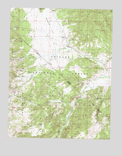
Sweetwater Creek, NV USGS Topographic Map
Click on map above to begin viewing in our Map Viewer.

This topographic map contains these locations and features:
Feature Name Type Latitude Longitude GNIS ID View Map
Atcheson Ranch (historical)LocaleN38.4596°W119.1902°858757View Map
Clinton (historical)LocaleN38.4391°W119.2349°251932View Map
Clinton SpringSpringN38.4413°W119.2388°221229View Map
Cottonwood CanyonValleyN38.4630°W119.2357°859367View Map
Cottonwood CanyonValleyN38.4694°W119.2254°221631View Map
Devils GateGapN38.4141°W119.1707°222302View Map
Feridell RanchLocaleN38.3963°W119.1807°223450View Map
Feridell RanchLocaleN38.3963°W119.1799°274795View Map
Ferris CanyonValleyN38.4402°W119.2204°859705View Map
Ferris CanyonValleyN38.4641°W119.1807°223476View Map
Fredericks Ranch (historical)LocaleN38.4266°W119.1538°859763View Map
Fryingpan CanyonValleyN38.4094°W119.2235°223977View Map
Fryingpan CreekStreamN38.4088°W119.1707°223978View Map
Green CreekStreamN38.4577°W119.1664°224540View Map
Little Fryingpan CanyonValleyN38.4105°W119.1832°227261View Map
Long Doctor SpringSpringN38.4966°W119.1979°860410View Map
Masonic GulchValleyN38.4355°W119.1349°234250View Map
Masonic GulchValleyN38.4246°W119.1329°860499View Map
Monte CristoLocaleN38.4116°W119.2302°228952View Map
Murphy PondLakeN38.4391°W119.2349°862147View Map
Philatro RanchLocaleN38.4066°W119.1715°274793View Map
Philatro Ranch (historical)LocaleN38.4063°W119.1729°230596View Map
Quaking Asp CanyonValleyN38.4730°W119.2052°231114View Map
Quaking Asp CanyonValleyN38.4682°W119.2327°861034View Map
Roach Ranch (historical)LocaleN38.4624°W119.1749°861126View Map
Round MountainSummitN38.4991°W119.2132°861190View Map
Silverado CanyonValleyN38.4574°W119.1963°233148View Map
Silverado CanyonValleyN38.4544°W119.2260°861393View Map
Star CityLocaleN38.4174°W119.2435°235388View Map
Sweetwater (historical)Populated PlaceN38.4624°W119.1749°847807View Map
Sweetwater CanyonValleyN38.4777°W119.2188°268024View Map
Sweetwater CreekStreamN38.4346°W119.1282°861650View Map
Sweetwater FlatFlatN38.4944°W119.2024°861651View Map
Sweetwater Guard Station (historical)LocaleN38.4891°W119.1943°861652View Map
Sweetwater Natural AreaAreaN38.4888°W119.1593°864213View Map
Sweetwater Post Office (historical)Post OfficeN38.4624°W119.1749°864534View Map
Sweetwater RanchLocaleN38.4713°W119.1846°861654View Map
Water CanyonValleyN38.4030°W119.1724°237319View Map
Wedertz FlatFlatN38.3833°W119.2140°237394View Map
Williams Stage Station Historical SiteLocaleN38.4038°W119.1696°274794View Map

Note: Coordinates in the location and feature list above are referenced to NAD83 datum.


Copyright (C) 2008-2025 Ryan Niemi / Sunset Dynamics ... All Rights Reserved