TopoQuest Logo
Do you find TopoQuest useful?
Help keep TopoQuest running and adding new maps/features by donating!
Bitcoin:  19c7KJd3qBynnjoSw5npx9KScwjBe4ifkT
Litecoin:  LXs6TkuXGGXo1vDsWCkWVdjQX94eUKd6ui
Home View Maps Find Maps Find Places Resources & Links


Bloomfield, Kentucky Topographic Map

USGS Map Title: Bloomfield, KY
USGS Map MRC: 37085H3
DRG (GeoTIFF) Download: o37085h3.tif


Neighboring USGS Topographic Map Quads:


  Waterford, KY  
38085A4
 

  Taylorsville, KY  
38085A3
 

  Mount Eden, KY  
38085A2
 

  Fairfield, KY  
37085H4
 

  Bloomfield, KY  
37085H3
 

  Chaplin, KY  
37085H2
 

  Bardstown, KY  
37085G4
 

  Maud, KY  
37085G3
 

  Brush Grove, KY  
37085G2


Map MRC Location:

N38°
W86°
N38°
W85°
H8 H7 H6 H5 H4 H3 H2 H1
G8 G7 G6 G5 G4 G3 G2 G1
F8 F7 F6 F5 F4 F3 F2 F1
E8 E7 E6 E5 E4 E3 E2 E1
D8 D7 D6 D5 D4 D3 D2 D1
C8 C7 C6 C5 C4 C3 C2 C1
B8 B7 B6 B5 B4 B3 B2 B1
A8 A7 A6 A5 A4 A3 A2 A1
N37°
W86°
N37°
W85°

Bloomfield, KY USGS 1:24K Topographic Map Preview:
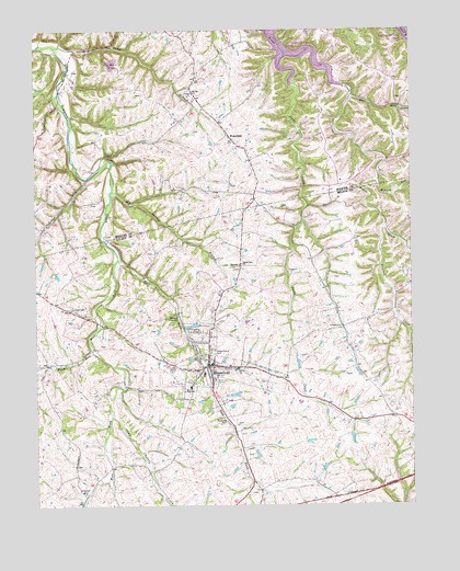
Bloomfield, KY USGS Topographic Map
Click on map above to begin viewing in our Map Viewer.

This topographic map contains these locations and features:
Feature Name Type Latitude Longitude GNIS ID View Map
Ashes Creek ChurchChurchN37.9912°W85.2797°486090View Map
Ashes Creek Union Church (historical)ChurchN37.9946°W85.2898°2567858View Map
Beauchamp Tragedy Historical MarkerParkN37.9162°W85.3175°2744628View Map
Big Springs BranchStreamN37.9578°W85.3486°487273View Map
Big Springs ChurchChurchN37.9387°W85.3064°487275View Map
BloomfieldPopulated PlaceN37.9103°W85.3166°487497View Map
Bloomfield DivisionCivilN37.9066°W85.2615°1936879View Map
Bloomfield Police DepartmentBuildingN37.9136°W85.3206°2767451View Map
Bowman CreekStreamN37.9827°W85.3675°2567860View Map
Brown Junior High SchoolSchoolN37.9062°W85.3236°488009View Map
Camp BranchStreamN37.9956°W85.3675°488675View Map
Camp Charity CreekStreamN37.8984°W85.3500°488682View Map
City of BloomfieldCivilN37.9122°W85.3140°2403879View Map
Doe RunStreamN37.9826°W85.2686°490967View Map
East Fork Simpson CreekStreamN37.9401°W85.3475°491478View Map
Fairfield CemeteryCemeteryN37.9264°W85.3636°491877View Map
Fairfield HillSummitN37.9403°W85.2972°2742386View Map
Grays RunStreamN37.9612°W85.3580°493219View Map
Hahntown (historical)Populated PlaceN37.8931°W85.2634°2742390View Map
Ham Brown Log Cabin Historical MarkerParkN37.9250°W85.3156°2744677View Map
Hinkle CreekStreamN37.9117°W85.3177°494296View Map
Hunters CemeteryCemeteryN37.9449°W85.3650°2567882View Map
Hunters CreekStreamN37.9481°W85.2586°494787View Map
Ingram CemeteryCemeteryN37.9819°W85.2530°2567883View Map
Jacks CreekStreamN37.9934°W85.2902°495091View Map
James Guthrie Historical MarkerParkN37.9135°W85.3204°2744659View Map
Lick RunStreamN37.9058°W85.3461°2742394View Map
Maple Grove CemeteryCemeteryN37.9159°W85.3152°497504View Map
Millers RunStreamN37.9603°W85.2605°498362View Map
Mount Zion ChurchChurchN37.9831°W85.3208°498946View Map
Moxley RunStreamN37.9064°W85.3452°2742396View Map
Northeast Nelson Volunteer Fire DepartmentBuildingN37.9137°W85.3203°2636888View Map
Oberlies Railroad Station (historical)LocaleN37.9822°W85.3213°2567895View Map
Plum RunStreamN37.9164°W85.3559°500974View Map
Raymond Greer RunStreamN37.9516°W85.3676°2567899View Map
Rogers CemeteryCemeteryN37.9590°W85.3097°2567902View Map
School Number Seven (historical)SchoolN37.9593°W85.2735°2567905View Map
School Number Seventeen (historical)SchoolN37.9950°W85.2901°2554984View Map
Smileytown Post Office (historical)Post OfficeN37.9641°W85.3029°2567911View Map
WakefieldPopulated PlaceN37.9717°W85.3080°509301View Map
Wakefield PondLakeN37.9707°W85.3027°2567916View Map
Wakefield Post Office (historical)Post OfficeN37.9713°W85.3090°2567917View Map
Wakefield Railroad Station (historical)LocaleN37.9711°W85.3088°2567918View Map
Wakefield School (historical)SchoolN37.9792°W85.3189°2567919View Map
Walnut Groves Farm Historical MarkerParkN37.9229°W85.3159°2744676View Map
West Fork Simpson CreekStreamN37.9403°W85.3472°506449View Map
Wilkinson CemeteryCemeteryN37.8784°W85.3594°506767View Map
Zion (historical)Populated PlaceN37.9840°W85.3234°2567927View Map

Note: Coordinates in the location and feature list above are referenced to NAD83 datum.


Copyright (C) 2008-2024 Ryan Niemi / Sunset Dynamics ... All Rights Reserved