TopoQuest Logo
Do you find TopoQuest useful?
Help keep TopoQuest running and adding new maps/features by donating!
Bitcoin:  19c7KJd3qBynnjoSw5npx9KScwjBe4ifkT
Litecoin:  LXs6TkuXGGXo1vDsWCkWVdjQX94eUKd6ui
Home View Maps Find Maps Find Places Resources & Links


Waterford, Kentucky Topographic Map

USGS Map Title: Waterford, KY
USGS Map MRC: 38085A4
DRG (GeoTIFF) Download: o38085a4.tif


Neighboring USGS Topographic Map Quads:


  Jeffersontown, KY  
38085B5
 

  Fisherville, KY  
38085B4
 

  Simpsonville, KY  
38085B3
 

  Mount Washington, KY  
38085A5
 

  Waterford, KY  
38085A4
 

  Taylorsville, KY  
38085A3
 

  Samuels, KY  
37085H5
 

  Fairfield, KY  
37085H4
 

  Bloomfield, KY  
37085H3


Map MRC Location:

N39°
W86°
N39°
W85°
H8 H7 H6 H5 H4 H3 H2 H1
G8 G7 G6 G5 G4 G3 G2 G1
F8 F7 F6 F5 F4 F3 F2 F1
E8 E7 E6 E5 E4 E3 E2 E1
D8 D7 D6 D5 D4 D3 D2 D1
C8 C7 C6 C5 C4 C3 C2 C1
B8 B7 B6 B5 B4 B3 B2 B1
A8 A7 A6 A5 A4 A3 A2 A1
N38°
W86°
N38°
W85°

Waterford, KY USGS 1:24K Topographic Map Preview:
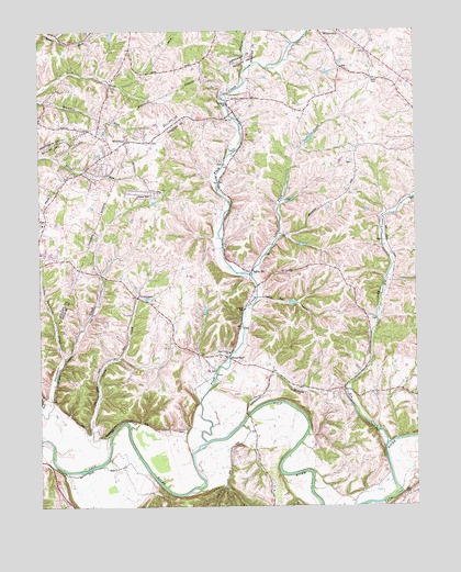
Waterford, KY USGS Topographic Map
Click on map above to begin viewing in our Map Viewer.

This topographic map contains these locations and features:
Feature Name Type Latitude Longitude GNIS ID View Map
Carrithers ChapelChurchN38.1187°W85.4000°488979View Map
Chadbourn BranchStreamN38.0240°W85.4305°489297View Map
CrenshawPopulated PlaceN38.0548°W85.4669°507778View Map
Crenshaw Post Office (historical)Post OfficeN38.0403°W85.4894°2567865View Map
Drakes BranchStreamN38.1145°W85.4288°491092View Map
Elk CreekStreamN38.0165°W85.3850°491657View Map
Feather Bed HollowValleyN38.0550°W85.4268°492012View Map
Forman School (historical)SchoolN38.0313°W85.4034°2567873View Map
Formans Ford (historical)CrossingN38.0240°W85.4310°2567874View Map
Goose CreekStreamN38.0189°W85.4769°492998View Map
Kings ChurchChurchN38.0740°W85.4991°495759View Map
Little Dutchman CreekStreamN38.0390°W85.4916°496712View Map
Little Plum CreekStreamN38.0603°W85.4288°496828View Map
Locust Gove School (historical)SchoolN38.0636°W85.4052°2567888View Map
Lucas Ford (historical)CrossingN38.0217°W85.4711°2567890View Map
Mount Washington Fire DepartmentBuildingN38.0939°W85.4742°2636662View Map
Oak Grove School (historical)SchoolN38.0792°W85.4608°2567894View Map
Pleasant Valley School (historical)SchoolN38.0354°W85.4938°2567897View Map
Plum CreekStreamN38.0170°W85.4450°500965View Map
Plum Creek Baptist ChurchChurchN38.0404°W85.4372°500967View Map
School Number Three (historical)SchoolN38.0359°W85.4424°2567908View Map
Silo FarmsLocaleN38.0986°W85.3954°2567910View Map
Spencer County Fire Protection District Station 3BuildingN38.0367°W85.4323°2637434View Map
WaterfordPopulated PlaceN38.0390°W85.4372°506264View Map
Waterford Post Office (historical)Post OfficeN38.0238°W85.4307°2567920View Map
Waterford Reform Church (historical)ChurchN38.0338°W85.4414°2567921View Map
West Spencer DivisionCivilN38.0461°W85.4040°1937270View Map
WhitfieldPopulated PlaceN38.0962°W85.4705°517327View Map

Note: Coordinates in the location and feature list above are referenced to NAD83 datum.


Copyright (C) 2008-2024 Ryan Niemi / Sunset Dynamics ... All Rights Reserved