TopoQuest Logo
Do you find TopoQuest useful?
Help keep TopoQuest running and adding new maps/features by donating!
Bitcoin:  19c7KJd3qBynnjoSw5npx9KScwjBe4ifkT
Litecoin:  LXs6TkuXGGXo1vDsWCkWVdjQX94eUKd6ui
Home View Maps Find Maps Find Places Resources & Links


Tatoosh Buttes, Washington Topographic Map

USGS Map Title: Tatoosh Buttes, WA
USGS Map MRC: 48120H5
DRG (GeoTIFF) Download: o48120h5.tif


Neighboring USGS Topographic Map Quads:


  Frosty Creek, WA  
48120H6
 

  Tatoosh Buttes, WA  
48120H5
 

  Ashnola Mountain, WA  
48120H4
 

  Pasayten Peak, WA  
48120G6
 

  Mount Lago, WA  
48120G5
 

  Lost Peak, WA  
48120G4


Map MRC Location:

N49°
W121°
N49°
W120°
H8 H7 H6 H5 H4 H3 H2 H1
G8 G7 G6 G5 G4 G3 G2 G1
F8 F7 F6 F5 F4 F3 F2 F1
E8 E7 E6 E5 E4 E3 E2 E1
D8 D7 D6 D5 D4 D3 D2 D1
C8 C7 C6 C5 C4 C3 C2 C1
B8 B7 B6 B5 B4 B3 B2 B1
A8 A7 A6 A5 A4 A3 A2 A1
N48°
W121°
N48°
W120°

Tatoosh Buttes, WA USGS 1:24K Topographic Map Preview:
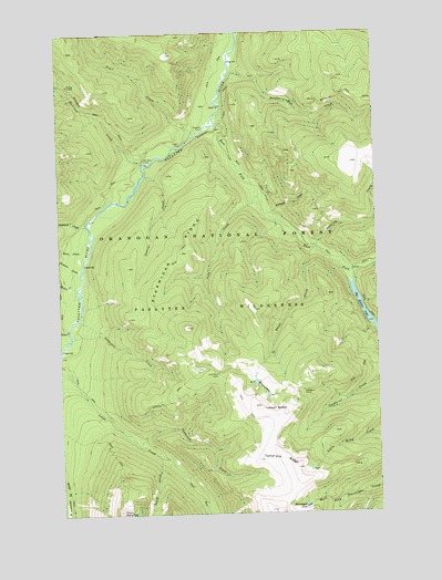
Tatoosh Buttes, WA USGS Topographic Map
Click on map above to begin viewing in our Map Viewer.

This topographic map contains these locations and features:
Feature Name Type Latitude Longitude GNIS ID View Map
Big Hidden LakeLakeN48.9246°W120.5033°1516516View Map
Bunker Hill CreekStreamN48.9901°W120.5573°1517101View Map
Burn CreekStreamN48.9462°W120.6137°1517114View Map
Central CreekStreamN48.9629°W120.5923°1517595View Map
East Fork Pasayten RiverStreamN48.9790°W120.5618°1519120View Map
Farewell CreekStreamN48.9526°W120.5446°1519475View Map
Getaway CreekStreamN48.9432°W120.5262°1519929View Map
Gunbarrel CampLocaleN48.9063°W120.5307°1520410View Map
Harrison CampLocaleN48.9668°W120.5926°1520570View Map
Harrison CreekStreamN48.9660°W120.5929°1520572View Map
Holdover CreekStreamN48.9504°W120.6154°1520859View Map
Honess CreekStreamN48.9382°W120.6196°1520881View Map
Judy CreekStreamN48.9571°W120.5473°1521487View Map
Lodgepole CreekStreamN48.9212°W120.6212°1522347View Map
Lone Buck CampLocaleN48.9107°W120.5646°1522359View Map
Lunch CreekStreamN48.8901°W120.5879°1522577View Map
Pasayten CabinLocaleN48.9749°W120.5684°1524227View Map
Point DefianceSummitN48.8751°W120.6029°1524533View Map
Ptarmigan LakeLakeN48.8766°W120.5301°1524674View Map
Ptarmigan RidgeRidgeN48.9426°W120.5784°1524678View Map
Rainy CampLocaleN48.9868°W120.6215°1524835View Map
Soda CreekStreamN48.9232°W120.6229°1526078View Map
Sunset MeadowFlatN48.9090°W120.6123°1530087View Map
Tamarack CreekStreamN48.8929°W120.5965°1526918View Map
Tamarack RidgeRidgeN48.8863°W120.5340°1526921View Map
Tatoosh ButtesSummitN48.9018°W120.5418°1526948View Map
Thomson CreekStreamN48.9387°W120.6165°1527115View Map
Trail CreekStreamN48.9729°W120.5718°1527343View Map
White CreekStreamN48.9435°W120.5265°1528056View Map
White LakeLakeN48.9090°W120.5496°1529749View Map
White LakesLakeN48.9068°W120.5479°1528066View Map

Note: Coordinates in the location and feature list above are referenced to NAD83 datum.


Copyright (C) 2008-2025 Ryan Niemi / Sunset Dynamics ... All Rights Reserved