TopoQuest Logo
Do you find TopoQuest useful?
Help keep TopoQuest running and adding new maps/features by donating!
Bitcoin:  19c7KJd3qBynnjoSw5npx9KScwjBe4ifkT
Litecoin:  LXs6TkuXGGXo1vDsWCkWVdjQX94eUKd6ui
Home View Maps Find Maps Find Places Resources & Links


Tea Table Mountain, Oregon Topographic Map

USGS Map Title: Tea Table Mountain, OR
USGS Map MRC: 43121B5
DRG (GeoTIFF) Download: o43121b5.tif


Neighboring USGS Topographic Map Quads:


  Walker Mountain, OR  
43121C6
 

  Sellers Marsh, OR  
43121C5
 

  Stams Mountain, OR  
43121C4
 

  Sugarpine Mountain NW, OR  
43121B6
 

  Tea Table Mountain, OR  
43121B5
 

  Location Butte, OR  
43121B4
 

  Round Butte, OR  
43121A6
 

  Sugarpine Mountain, OR  
43121A5
 

  Bear Butte, OR  
43121A4


Map MRC Location:

N44°
W122°
N44°
W121°
H8 H7 H6 H5 H4 H3 H2 H1
G8 G7 G6 G5 G4 G3 G2 G1
F8 F7 F6 F5 F4 F3 F2 F1
E8 E7 E6 E5 E4 E3 E2 E1
D8 D7 D6 D5 D4 D3 D2 D1
C8 C7 C6 C5 C4 C3 C2 C1
B8 B7 B6 B5 B4 B3 B2 B1
A8 A7 A6 A5 A4 A3 A2 A1
N43°
W122°
N43°
W121°

Tea Table Mountain, OR USGS 1:24K Topographic Map Preview:
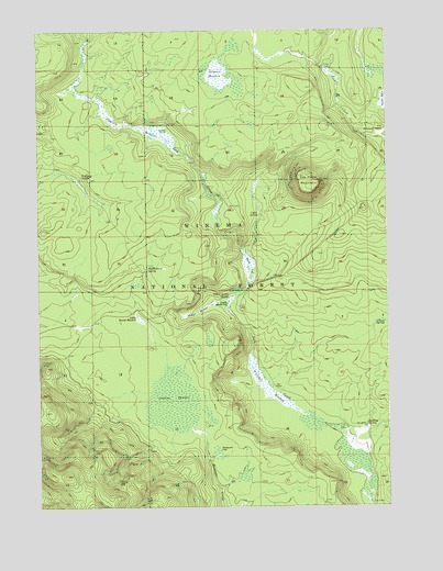
Tea Table Mountain, OR USGS Topographic Map
Click on map above to begin viewing in our Map Viewer.

This topographic map contains these locations and features:
Feature Name Type Latitude Longitude GNIS ID View Map
Bullfrog SpringSpringN43.1464°W121.5089°1138935View Map
Cabin SpringSpringN43.2017°W121.5469°1139115View Map
Cleary SpringSpringN43.1728°W121.5054°1139813View Map
Davis FlatSwampN43.1879°W121.5507°1140665View Map
Dempsey SpringSpringN43.2118°W121.6103°1140892View Map
Hidden MeadowSwampN43.1766°W121.5684°1143548View Map
Huckleberry SpringSpringN43.1873°W121.5870°1143886View Map
Jackies ThicketSwampN43.1524°W121.5773°1144186View Map
Jamison MeadowSwampN43.2249°W121.5914°1144219View Map
Jamison RanchLocaleN43.2240°W121.5800°1144220View Map
Lily CampLocaleN43.1257°W121.5078°1145010View Map
Little Round MeadowSwampN43.1744°W121.5900°1145241View Map
Lower Davis FlatSwampN43.1785°W121.5586°1145612View Map
Mosquito FlatFlatN43.1390°W121.5625°1146495View Map
O'Conner MeadowSwampN43.1560°W121.5447°1147104View Map
Riders CampLocaleN43.2404°W121.5234°1148433View Map
Stimson MeadowSwampN43.2387°W121.5589°1150436View Map
Tea Table MountainSummitN43.2101°W121.5259°1150926View Map
The Rhubarb PatchAreaN43.2226°W121.5028°1151041View Map
Yellow Jacket SpringSpringN43.1799°W121.5581°1152710View Map

Note: Coordinates in the location and feature list above are referenced to NAD83 datum.


Copyright (C) 2008-2025 Ryan Niemi / Sunset Dynamics ... All Rights Reserved