TopoQuest Logo
Do you find TopoQuest useful?
Help keep TopoQuest running and adding new maps/features by donating!
Bitcoin:  19c7KJd3qBynnjoSw5npx9KScwjBe4ifkT
Litecoin:  LXs6TkuXGGXo1vDsWCkWVdjQX94eUKd6ui
Home View Maps Find Maps Find Places Resources & Links


Tehuacana, Texas Topographic Map

USGS Map Title: Tehuacana, TX
USGS Map MRC: 31096F5
DRG (GeoTIFF) Download: o31096f5.tif


Neighboring USGS Topographic Map Quads:


  Coolidge, TX  
31096G6
 

  Union High, TX  
31096G5
 

  Wortham, TX  
31096G4
 

  Echols, TX  
31096F6
 

  Tehuacana, TX  
31096F5
 

  Mexia, TX  
31096F4
 

  Ben Hur, TX  
31096E6
 

  Groesbeck, TX  
31096E5
 

  Fallon, TX  
31096E4


Map MRC Location:

N32°
W97°
N32°
W96°
H8 H7 H6 H5 H4 H3 H2 H1
G8 G7 G6 G5 G4 G3 G2 G1
F8 F7 F6 F5 F4 F3 F2 F1
E8 E7 E6 E5 E4 E3 E2 E1
D8 D7 D6 D5 D4 D3 D2 D1
C8 C7 C6 C5 C4 C3 C2 C1
B8 B7 B6 B5 B4 B3 B2 B1
A8 A7 A6 A5 A4 A3 A2 A1
N31°
W97°
N31°
W96°

Tehuacana, TX USGS 1:24K Topographic Map Preview:
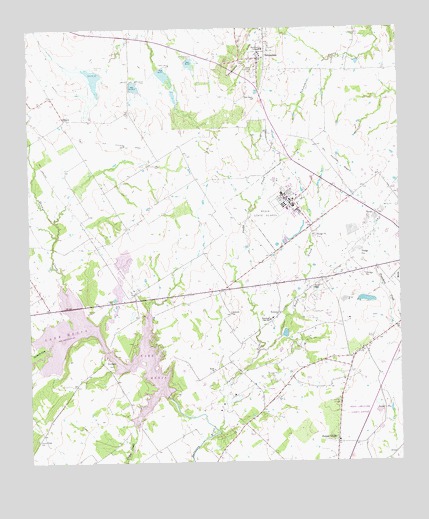
Tehuacana, TX USGS Topographic Map
Click on map above to begin viewing in our Map Viewer.

This topographic map contains these locations and features:
Feature Name Type Latitude Longitude GNIS ID View Map
Bethesda ChurchChurchN31.6682°W96.5572°1351965View Map
Bethlehem ChurchChurchN31.6682°W96.5405°1351973View Map
Bistone DamDamN31.6435°W96.5786°1856330View Map
Booker T Washington Emancipation Proclamation ParkParkN31.6571°W96.5969°2031862View Map
Cedar CreekStreamN31.6363°W96.5900°1373010View Map
Christmas CreekStreamN31.6577°W96.6203°1373099View Map
Comanche SpringSpringN31.6568°W96.6011°1998522View Map
Confederate Reunion Grounds State Historical ParkParkN31.6324°W96.5594°2028534View Map
Dam Number 20DamN31.7371°W96.6005°1355584View Map
Dam Number 20ADamN31.7352°W96.5900°1355586View Map
Dam Number 21DamN31.7385°W96.5803°1355587View Map
Dam Number 22DamN31.7407°W96.5714°1355589View Map
DaturaPopulated PlaceN31.7243°W96.6130°1379639View Map
Forest GladePopulated PlaceN31.6307°W96.5219°1357557View Map
Forest Glade CemeteryCemeteryN31.6424°W96.5219°1357558View Map
Fortson LakeReservoirN31.6717°W96.5112°1856333View Map
Fortson Lake DamDamN31.6718°W96.5103°1856332View Map
Honest Ridge CemeteryCemeteryN31.6318°W96.6230°1359491View Map
Jacks CreekStreamN31.6338°W96.5619°1360093View Map
Joe Echols Dam Number 2DamN31.6385°W96.5669°1856328View Map
Joe Echols Lake Number 2ReservoirN31.6385°W96.5669°1856329View Map
Joseph E Johnston Confederate Reunion GroundsLocaleN31.6368°W96.5561°2032069View Map
KYCX-FM (Mexia)TowerN31.7071°W96.5233°1385938View Map
Lake MexiaReservoirN31.6585°W96.5997°1362676View Map
Lake Mexia Volunteer Fire DepartmentBuildingN31.6554°W96.6011°2552590View Map
Mexia DivisionCivilN31.6882°W96.5114°1938991View Map
Mexia Oil FieldOilfieldN31.6724°W96.5222°1362674View Map
Mexia State SchoolSchoolN31.7007°W96.5369°1362675View Map
Mexia State School Fire BrigadeBuildingN31.7000°W96.5363°2552471View Map
Mexia-Limestone County AirportAirportN31.6398°W96.5147°1384818View Map
New Hope ChurchChurchN31.7293°W96.5483°1363740View Map
Old Trinity University - Texas HallSchoolN31.7441°W96.5455°2031858View Map
Rocky CreekStreamN31.6563°W96.5486°1366766View Map
Sandy CreekStreamN31.6757°W96.6128°1367714View Map
Sardis ChurchChurchN31.6518°W96.5633°1367778View Map
Smith ChapelChurchN31.6746°W96.5300°1368474View Map
Soil Conservation Service Site 20 DamDamN31.7377°W96.6010°1856326View Map
Soil Conservation Service Site 20 ReservoirReservoirN31.7370°W96.6020°1856327View Map
Soil Conservation Service Site 20a DamDamN31.7353°W96.5900°1856324View Map
Soil Conservation Service Site 20a ReservoirReservoirN31.7352°W96.5903°1856325View Map
Soil Conservation Service Site 21 DamDamN31.7384°W96.5808°1856322View Map
Soil Conservation Service Site 21 ReservoirReservoirN31.7370°W96.5792°1856323View Map
Soil Conservation Service Site 22 DamDamN31.7413°W96.5712°1856320View Map
Soil Conservation Service Site 22 ReservoirReservoirN31.7402°W96.5706°1856321View Map
TehuacanaPopulated PlaceN31.7413°W96.5469°1376406View Map
Tehuacana City HallBuildingN31.7417°W96.5465°2753752View Map
Tehuacana HillsSummitN31.7421°W96.5525°1369682View Map
Tehuacana Post OfficePost OfficeN31.7417°W96.5465°2731876View Map
Tehuacana SpringSpringN31.7482°W96.5364°1998523View Map
Tehuacana Volunteer Fire DepartmentBuildingN31.7423°W96.5459°2552307View Map
Town of TehuacanaCivilN31.7410°W96.5436°2413370View Map
Washington ParkParkN31.6535°W96.5980°1370882View Map
Westminster College (historical)SchoolN31.7443°W96.5458°1371299View Map
Woodland High SchoolSchoolN31.6660°W96.5441°1371916View Map

Note: Coordinates in the location and feature list above are referenced to NAD83 datum.


Copyright (C) 2008-2025 Ryan Niemi / Sunset Dynamics ... All Rights Reserved