TopoQuest Logo
Do you find TopoQuest useful?
Help keep TopoQuest running and adding new maps/features by donating!
Bitcoin:  19c7KJd3qBynnjoSw5npx9KScwjBe4ifkT
Litecoin:  LXs6TkuXGGXo1vDsWCkWVdjQX94eUKd6ui
Home View Maps Find Maps Find Places Resources & Links


Ten Mile, Tennessee Topographic Map

USGS Map Title: Ten Mile, TN
USGS Map MRC: 35084F6
DRG (GeoTIFF) Download: o35084f6.tif


Neighboring USGS Topographic Map Quads:


  Roddy, TN  
35084G7
 

  Rockwood, TN  
35084G6
 

  Bacon Gap, TN  
35084G5
 

  Spring City, TN  
35084F7
 

  Ten Mile, TN  
35084F6
 

  Pattie Gap, TN  
35084F5
 

  Decatur, TN  
35084E7
 

  Tranquillity, TN  
35084E6
 

  Niota, TN  
35084E5


Map MRC Location:

N36°
W85°
N36°
W84°
H8 H7 H6 H5 H4 H3 H2 H1
G8 G7 G6 G5 G4 G3 G2 G1
F8 F7 F6 F5 F4 F3 F2 F1
E8 E7 E6 E5 E4 E3 E2 E1
D8 D7 D6 D5 D4 D3 D2 D1
C8 C7 C6 C5 C4 C3 C2 C1
B8 B7 B6 B5 B4 B3 B2 B1
A8 A7 A6 A5 A4 A3 A2 A1
N35°
W85°
N35°
W84°

Ten Mile, TN USGS 1:24K Topographic Map Preview:
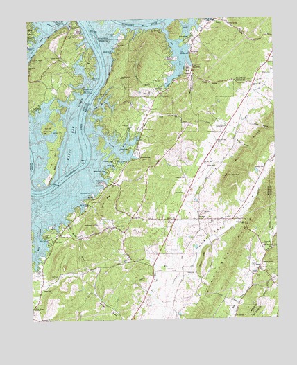
Ten Mile, TN USGS Topographic Map
Click on map above to begin viewing in our Map Viewer.

This topographic map contains these locations and features:
Feature Name Type Latitude Longitude GNIS ID View Map
Apollo ShoresPopulated PlaceN35.7462°W84.7491°1269307View Map
Arrowhead DockLocaleN35.7390°W84.7497°1320183View Map
Baker CemeteryCemeteryN35.6720°W84.7258°1304923View Map
Baker CemeteryCemeteryN35.6381°W84.7441°1276150View Map
Baldwin CemeteryCemeteryN35.6590°W84.6652°1276222View Map
BaysidePopulated PlaceN35.7487°W84.6610°1310396View Map
Bayside DockLocaleN35.7495°W84.6583°1316363View Map
Big Springs Access AreaParkN35.6948°W84.6958°1647234View Map
Bills PierLocaleN35.7406°W84.7411°1320186View Map
Blue SpringSpringN35.7300°W84.6657°1277784View Map
Blue Spring BranchStreamN35.7345°W84.6713°1310398View Map
Blue SpringsPopulated PlaceN35.7420°W84.6672°1277809View Map
Blue Springs DockLocaleN35.7362°W84.6680°1316365View Map
Blue Springs ResortPopulated PlaceN35.7365°W84.6674°1277813View Map
Bowdens Store (historical)LocaleN35.6909°W84.6994°1316101View Map
Branham HollowValleyN35.7304°W84.6667°1278232View Map
Camp Oo-tah-nee-noh-cheeLocaleN35.6901°W84.7030°1305634View Map
Campground on the LakeshoreParkN35.6992°W84.7022°1309883View Map
Cane CreekStreamN35.7465°W84.6810°1279506View Map
Cedine Bible CampLocaleN35.7453°W84.7261°1280108View Map
Commissioner District 5CivilN35.6674°W84.6916°2464476View Map
Concord CemeteryCemeteryN35.6423°W84.6358°1309894View Map
Concord ChurchChurchN35.6434°W84.6372°1306064View Map
Concord School (historical)SchoolN35.6423°W84.6363°1309897View Map
Cooley CemeteryCemeteryN35.7173°W84.6905°1309888View Map
Crabtree SpringSpringN35.6479°W84.6330°1281532View Map
Cross Key CemeteryCemeteryN35.7051°W84.6994°1281702View Map
Cross Key Chapel (historical)ChurchN35.7056°W84.6991°1309898View Map
CulvahousePopulated PlaceN35.6965°W84.6997°1281817View Map
Culvahouse CemeteryCemeteryN35.6781°W84.7191°1281818View Map
Deatherage CemeteryCemeteryN35.7045°W84.6544°1306310View Map
Dodd HollowValleyN35.7069°W84.6378°1282556View Map
Dry ForkStreamN35.6479°W84.6341°1303441View Map
Dry Fork ValleyValleyN35.6546°W84.6280°1282983View Map
Eden of the LakePopulated PlaceN35.7292°W84.7272°1283505View Map
Edgemon CemeteryCemeteryN35.6551°W84.6316°1283515View Map
Edgemon Church (historical)ChurchN35.6548°W84.6319°1309902View Map
Edgemon LakeReservoirN35.6862°W84.6346°1283516View Map
EucheePopulated PlaceN35.6759°W84.7169°1315028View Map
Euchee ChapelChurchN35.7348°W84.7336°1283878View Map
Euchee DockLocaleN35.6831°W84.7124°1283879View Map
Euchee Old Fields (historical)LocaleN35.6917°W84.7291°1320206View Map
Euchee School (historical)SchoolN35.7345°W84.7336°1320207View Map
Euchee School (historical)SchoolN35.6779°W84.7141°1309903View Map
Evans BranchStreamN35.7217°W84.6830°1283893View Map
Ewing CemeteryCemeteryN35.7026°W84.6549°1283941View Map
Ewings School (historical)SchoolN35.7026°W84.6544°1643451View Map
Fellowship Baptist Church (historical)ChurchN35.6628°W84.7361°1309904View Map
Gilbert RidgeRidgeN35.6495°W84.6616°1285370View Map
Gillaspies Ferry (historical)CrossingN35.7028°W84.7230°1309909View Map
Gillespie BendBendN35.6865°W84.7380°1285399View Map
Gillespie CemeteryCemeteryN35.7031°W84.7333°1285400View Map
Gillespie CemeteryCemeteryN35.7276°W84.7374°1285401View Map
Gordon SpringSpringN35.7477°W84.6475°1285703View Map
Gravelly HollowValleyN35.7045°W84.7480°1311748View Map
Half Moon ShoresPopulated PlaceN35.7290°W84.6694°1315176View Map
Holloway SpringSpringN35.7040°W84.6925°1288094View Map
Hornsby ChapelCemeteryN35.6906°W84.7069°1288381View Map
Hornsby Hollow Recreation AreaParkN35.6929°W84.7083°1309917View Map
Hornsbys Chapel Methodist Church (historical)ChurchN35.6865°W84.7027°1643460View Map
Huff CemeteryCemeteryN35.6431°W84.7402°1288636View Map
Hurricane CreekStreamN35.6401°W84.6861°1288810View Map
Hurricane ValleyValleyN35.6397°W84.6766°1288842View Map
Iron HillSummitN35.7051°W84.7413°1289047View Map
Iron Hill (historical)Populated PlaceN35.7084°W84.7388°1311752View Map
Iron Hill IslandIslandN35.6965°W84.7377°1289049View Map
Johnson CemeteryCemeteryN35.6776°W84.6719°1289550View Map
Johnson CemeteryCemeteryN35.7359°W84.6680°1289553View Map
Keylon HollowValleyN35.7271°W84.6661°1290131View Map
Keylon SpringsSpringN35.6841°W84.6712°1290132View Map
Looney RidgeRidgeN35.6748°W84.7113°1292049View Map
Luminary CemeteryCemeteryN35.7462°W84.6577°1292272View Map
Maple GrovePopulated PlaceN35.7120°W84.6888°1315460View Map
Maple Grove ChurchChurchN35.7104°W84.6899°1309922View Map
Marney CreekStreamN35.6987°W84.6999°1292719View Map
Mary Crabtree School (historical)SchoolN35.7398°W84.6694°1316417View Map
McCaleb CemeteryCemeteryN35.7212°W84.7227°1293096View Map
McCall BranchStreamN35.6670°W84.7338°1293100View Map
McPherson CemeteryCemeteryN35.6887°W84.6558°1283940View Map
Meigs Cabin AreaPopulated PlaceN35.6873°W84.7102°1647739View Map
Meigs County Emergency Services Fire Rescue Station 5BuildingN35.6665°W84.6804°2654298View Map
Morris Island (historical)IslandN35.7420°W84.7152°1310334View Map
Mount Wesley CemeteryCemeteryN35.6456°W84.6916°1294851View Map
Mount Wesley Methodist Church (historical)ChurchN35.6456°W84.6911°1309926View Map
Mount Zion CemeteryCemeteryN35.6251°W84.6466°1294866View Map
Nebo BranchStreamN35.6479°W84.6872°1295291View Map
No Pone RidgeRidgeN35.6292°W84.6472°1309927View Map
Old Hope CemeteryCemeteryN35.7426°W84.7216°1320243View Map
Old Pleasant Hill CemeteryCemeteryN35.6640°W84.7163°1296348View Map
Old Ten Mile Cemetery (historical)CemeteryN35.6634°W84.6638°1320107View Map
Parker CemeteryCemeteryN35.7431°W84.7497°1296808View Map
Peakland ChurchChurchN35.6251°W84.7455°1297063View Map
Pearl HarborBayN35.7148°W84.7141°1297072View Map
Pleasant HillPopulated PlaceN35.6634°W84.7083°1297843View Map
Pleasant Hill CemeteryCemeteryN35.6626°W84.7055°1320109View Map
Pleasant Hill Methodist ChurchChurchN35.6634°W84.7052°1309934View Map
Pleasant Hill School (historical)SchoolN35.6629°W84.7044°1643481View Map
Ponderosa ResortLocaleN35.7323°W84.7491°1298120View Map
Ray CemeteryCemeteryN35.7245°W84.6827°1298990View Map
Rector BranchStreamN35.7448°W84.7405°1299031View Map
Red Cloud CampgroundLocaleN35.7204°W84.7227°1299043View Map
Reed CemeteryCemeteryN35.7012°W84.6894°1299126View Map
Rocky Springs CemeteryCemeteryN35.6312°W84.7480°1320111View Map
Rocky Springs ChurchChurchN35.6309°W84.7486°1299935View Map
Roork CemeteryCemeteryN35.6606°W84.7433°1300050View Map
Rowden BranchStreamN35.7026°W84.7158°1300195View Map
Sams DockLocaleN35.6584°W84.7422°1300644View Map
Sand IslandIslandN35.6820°W84.7452°1311762View Map
Sensaboy SpringSpringN35.6923°W84.6935°1301064View Map
Sharp CemeteryCemeteryN35.6445°W84.6710°1301257View Map
South Roane County Volunteer Fire Department Station 5BuildingN35.7247°W84.6855°2654687View Map
Stump Hollow CampgroundLocaleN35.7128°W84.7480°1271621View Map
SurprisePopulated PlaceN35.6462°W84.6338°1314364View Map
Tabor (historical)Populated PlaceN35.7229°W84.6349°1644138View Map
Ten MilePopulated PlaceN35.6667°W84.6647°1304039View Map
Ten Mile Division (historical)CensusN35.6326°W84.7111°1648877View Map
Ten Mile Elementary SchoolSchoolN35.6656°W84.6799°1648179View Map
Ten Mile KnobSummitN35.6845°W84.6491°1272297View Map
Ten Mile Methodist ChurchChurchN35.6637°W84.6644°1643489View Map
Ten Mile Post OfficePost OfficeN35.6599°W84.7356°1650158View Map
Ten Mile RidgeRidgeN35.7012°W84.6327°1272298View Map
Terrace View ResortLocaleN35.7478°W84.7277°1272321View Map
Wann BranchStreamN35.6637°W84.7466°1304367View Map
Wasson CemeteryCemeteryN35.6742°W84.7185°1273871View Map
Watts Bar EstatesPopulated PlaceN35.7370°W84.7197°1273941View Map
White Creek ShoalsBarN35.7359°W84.7136°1309950View Map
Williams CemeteryCemeteryN35.7265°W84.6299°1274651View Map
Woodys Mill (historical)LocaleN35.6479°W84.6330°1316118View Map
Woolsey CemeteryCemeteryN35.7023°W84.6435°1275112View Map
Woolsey HollowValleyN35.7022°W84.6464°1275115View Map

Note: Coordinates in the location and feature list above are referenced to NAD83 datum.


Copyright (C) 2008-2024 Ryan Niemi / Sunset Dynamics ... All Rights Reserved