TopoQuest Logo
Do you find TopoQuest useful?
Help keep TopoQuest running and adding new maps/features by donating!
Bitcoin:  19c7KJd3qBynnjoSw5npx9KScwjBe4ifkT
Litecoin:  LXs6TkuXGGXo1vDsWCkWVdjQX94eUKd6ui
Home View Maps Find Maps Find Places Resources & Links


Decatur, Tennessee Topographic Map

USGS Map Title: Decatur, TN
USGS Map MRC: 35084E7
DRG (GeoTIFF) Download: o35084e7.tif


Neighboring USGS Topographic Map Quads:


  Pennine, TN  
35084F8
 

  Spring City, TN  
35084F7
 

  Ten Mile, TN  
35084F6
 

  Evensville, TN  
35084E8
 

  Decatur, TN  
35084E7
 

  Tranquillity, TN  
35084E6
 

  Big Spring, TN  
35084D8
 

  Goodfield, TN  
35084D7
 

  Riceville, TN  
35084D6


Map MRC Location:

N36°
W85°
N36°
W84°
H8 H7 H6 H5 H4 H3 H2 H1
G8 G7 G6 G5 G4 G3 G2 G1
F8 F7 F6 F5 F4 F3 F2 F1
E8 E7 E6 E5 E4 E3 E2 E1
D8 D7 D6 D5 D4 D3 D2 D1
C8 C7 C6 C5 C4 C3 C2 C1
B8 B7 B6 B5 B4 B3 B2 B1
A8 A7 A6 A5 A4 A3 A2 A1
N35°
W85°
N35°
W84°

Decatur, TN USGS 1:24K Topographic Map Preview:
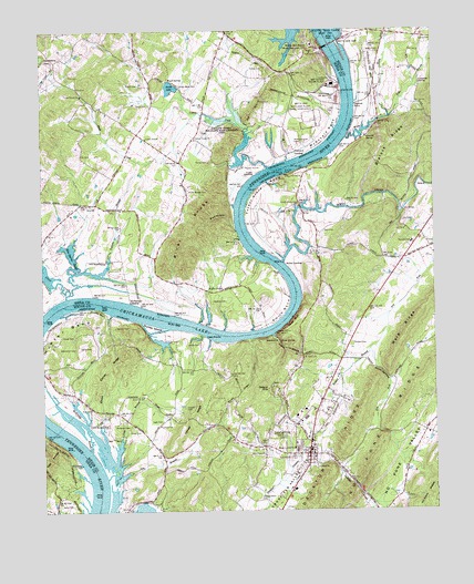
Decatur, TN USGS Topographic Map
Click on map above to begin viewing in our Map Viewer.

This topographic map contains these locations and features:
Feature Name Type Latitude Longitude GNIS ID View Map
Asbury Chapel (historical)ChurchN35.5745°W84.7616°1309875View Map
Ball CemeteryCemeteryN35.5727°W84.7849°1276231View Map
Blalock RidgeRidgeN35.5951°W84.7638°1277655View Map
Blue Spring SloughLakeN35.5626°W84.8612°1277808View Map
Bogles ChapelChurchN35.5578°W84.8169°1277876View Map
Bogles Chapel School (historical)SchoolN35.5578°W84.8180°1320188View Map
BreedentonPopulated PlaceN35.5440°W84.8008°1314729View Map
Buck HollowValleyN35.5735°W84.8134°1278818View Map
Burttram CemeteryCemeteryN35.5228°W84.8522°1305560View Map
Bush CreekStreamN35.6037°W84.8241°1279141View Map
Butcher BluffCliffN35.5445°W84.8069°1309882View Map
CalicoPopulated PlaceN35.5253°W84.8344°1314786View Map
Calvary ChurchChurchN35.5228°W84.8372°1305604View Map
Carp School (historical)SchoolN35.6153°W84.8452°1320190View Map
Carpenter SpringSpringN35.6110°W84.7541°1279711View Map
Cave SpringSpringN35.5917°W84.7616°1309884View Map
Clear CreekStreamN35.5556°W84.8672°1280660View Map
Commissioner District 3CivilN35.5065°W84.8204°2464178View Map
Concord CemeteryCemeteryN35.5306°W84.8422°1309895View Map
Concord ChurchChurchN35.5295°W84.8433°1309896View Map
Concord School (historical)SchoolN35.5295°W84.8430°1309887View Map
Cooke CemeteryCemeteryN35.5909°W84.8211°1281132View Map
Cooke LandingLocaleN35.5873°W84.8066°1314884View Map
Cooley CemeteryCemeteryN35.6226°W84.7535°1326645View Map
Correll CemeteryCemeteryN35.5273°W84.8291°1281329View Map
Correll RidgeRidgeN35.5240°W84.8288°1281330View Map
Dake BranchStreamN35.6023°W84.7633°1306254View Map
DeArmond CemeteryCemeteryN35.5423°W84.8638°1306297View Map
DecaturPopulated PlaceN35.5148°W84.7902°1306311View Map
Decatur BranchStreamN35.5081°W84.7986°1282273View Map
Decatur CemeteryCemeteryN35.5173°W84.7933°1320105View Map
Decatur Church of GodChurchN35.5117°W84.7908°1316165View Map
Decatur Division (historical)CensusN35.5203°W84.7988°1648876View Map
Decatur Fire DepartmentBuildingN35.5207°W84.7932°2654540View Map
Decatur Fire Department Station 1BuildingN35.5182°W84.7898°2654710View Map
Decatur First Baptist ChurchChurchN35.5167°W84.7891°1643938View Map
Decatur HillsPopulated PlaceN35.5315°W84.8002°1282274View Map
Decatur Post OfficePost OfficeN35.5195°W84.7912°1650143View Map
Decatur RidgeRidgeN35.5181°W84.7791°1306313View Map
Decatur United Methodist ChurchChurchN35.5128°W84.7919°1316166View Map
Ditney RidgeRidgeN35.5378°W84.8541°1306349View Map
Dry BranchStreamN35.5087°W84.8547°1282837View Map
Eaves BluffCliffN35.5495°W84.7949°1283449View Map
Eaves CemeteryCemeteryN35.5215°W84.8466°1283450View Map
Eaves SpringSpringN35.5436°W84.7991°1283452View Map
Englerock LandingLocaleN35.5459°W84.8241°1316104View Map
Eves Ferry (historical)CrossingN35.5467°W84.8027°1647235View Map
Ewing CemeteryCemeteryN35.6151°W84.8030°1283939View Map
FairviewPopulated PlaceN35.5653°W84.7597°1647236View Map
Fairview Elementary SchoolSchoolN35.5698°W84.7566°1648323View Map
Five Point ChurchChurchN35.5145°W84.8041°1284344View Map
Forest GrovePopulated PlaceN35.5820°W84.7930°1647237View Map
Forest Grove BendBendN35.5834°W84.8061°1284583View Map
Forest Grove BridgeBridgeN35.5795°W84.7919°1284584View Map
Forest Grove CemeteryCemeteryN35.5796°W84.7929°1284585View Map
Forest Grove School (historical)SchoolN35.5837°W84.7930°1643476View Map
Guinn NarrowsGapN35.5365°W84.7669°1286382View Map
Henleys Mill (historical)LocaleN35.5820°W84.8491°1316108View Map
Hunter BendBendN35.5506°W84.8683°1288727View Map
Hunter BluffCliffN35.5526°W84.8563°1288728View Map
Hunter CemeteryCemeteryN35.5481°W84.8513°1288734View Map
Hunter IslandIslandN35.5478°W84.8399°1288745View Map
Hutsell BranchStreamN35.5420°W84.7708°1288873View Map
Ingle CemeteryCemeteryN35.5234°W84.8369°1289005View Map
Ingle RocksSummitN35.5453°W84.8222°1289007View Map
Iron BridgeBridgeN35.5778°W84.7594°1289044View Map
Iron Bridge School (historical)SchoolN35.5745°W84.7619°1643461View Map
Johns ChapelChurchN35.5970°W84.8413°1289512View Map
Kincaid SpringSpringN35.5971°W84.7711°1290180View Map
Kings Mill (historical)LocaleN35.5784°W84.7611°1309920View Map
Leuty CemeteryCemeteryN35.6048°W84.7827°1291048View Map
Lick BranchStreamN35.5131°W84.8516°1291172View Map
Lillard BluffCliffN35.6012°W84.7638°1647818View Map
M and M DockLocaleN35.5873°W84.7969°1326638View Map
McDonald BendBendN35.5970°W84.7827°1293049View Map
McDonald School (historical)SchoolN35.6087°W84.7933°1320230View Map
McKinley BranchStreamN35.5165°W84.8594°1293367View Map
McPherson LandingLocaleN35.5545°W84.8463°1315492View Map
Meigs CountyCivilN35.5128°W84.8134°1639775View Map
Meigs County CourthouseBuildingN35.5151°W84.7897°1316167View Map
Meigs County SchoolSchoolN35.5156°W84.7941°1293551View Map
Meigs County Sheriff DepartmentBuildingN35.5224°W84.7940°2765962View Map
Moss Fishing DockLocaleN35.5876°W84.7972°1309923View Map
No Pone RidgeRidgeN35.5101°W84.7733°1295786View Map
Old Goodfield CemeteryCemeteryN35.5031°W84.8061°1296316View Map
Old Stewarts Landing (historical)LocaleN35.5459°W84.8011°1309928View Map
Piney River ShoalsBarN35.6242°W84.7847°1309932View Map
Pinhook FerryCrossingN35.6062°W84.7744°1297664View Map
Poe BranchStreamN35.5190°W84.8547°1297996View Map
Poe CemeteryCemeteryN35.5270°W84.8594°1298000View Map
Porter CemeteryCemeteryN35.6106°W84.8427°1298254View Map
Porter LakeReservoirN35.6101°W84.8334°1298266View Map
Porter Lake DamDamN35.6093°W84.8328°1307134View Map
Porter-Ward CemeteryCemeteryN35.6106°W84.8297°1298271View Map
Powers LandingLocaleN35.5131°W84.8577°1316116View Map
Presley HillSummitN35.5556°W84.7849°1647241View Map
Prices Ferry (historical)CrossingN35.5623°W84.7977°1309937View Map
River KnobsSummitN35.5728°W84.8272°1299495View Map
Seventh Day Adventist ChurchChurchN35.5095°W84.7944°1643484View Map
Sewee CreekStreamN35.5651°W84.7983°1301120View Map
Sewee Iron Works (historical)LocaleN35.5773°W84.7619°1309940View Map
Sewee LandingLocaleN35.5648°W84.7980°1315892View Map
Sims CemeteryCemeteryN35.6067°W84.8041°1270351View Map
SlabtownPopulated PlaceN35.6181°W84.8186°1311763View Map
Smith BendBendN35.5517°W84.7972°1270551View Map
Smith CemeteryCemeteryN35.5434°W84.8244°1270604View Map
Smith CemeteryCemeteryN35.5456°W84.8680°1270605View Map
Smith CemeteryCemeteryN35.6056°W84.8402°1270606View Map
Smith-Wilkey CemeteryCemeteryN35.5831°W84.8280°1303690View Map
Stewart BranchStreamN35.5459°W84.8011°1303831View Map
Stewart CemeteryCemeteryN35.5434°W84.7758°1271360View Map
Stewarts Chapel (historical)ChurchN35.5478°W84.7749°1643488View Map
Stumptoe School (historical)SchoolN35.5406°W84.7874°1316117View Map
Tadpole BranchStreamN35.5570°W84.8658°1272037View Map
Taylor CemeteryCemeteryN35.5426°W84.8591°1304018View Map
Taylor CemeteryCemeteryN35.5020°W84.8655°1272195View Map
Texas Grove ChurchChurchN35.6081°W84.8616°1272350View Map
Town of DecaturCivilN35.5276°W84.7927°2406365View Map
Vineyard LandingLocaleN35.5923°W84.7930°1314459View Map
Waltons Islands (historical)IslandN35.6126°W84.7780°1643492View Map
Waltons ShoalsBarN35.6145°W84.7783°1643493View Map
Ward RidgeRidgeN35.5512°W84.7547°1273794View Map
Ward SpringSpringN35.6122°W84.8338°1304375View Map
Watkins CemeteryCemeteryN35.5545°W84.8205°1304413View Map
Watts BarBarN35.6095°W84.7769°1309948View Map
Watts Bar DamDamN35.6209°W84.7816°1304420View Map
Watts Bar Dam Post OfficePost OfficeN35.6212°W84.7877°1648553View Map
Watts Bar Nuclear PlantLocaleN35.6033°W84.7869°1273942View Map
Watts Bar ResortLocaleN35.6215°W84.7877°1273943View Map
Watts Bar Steam PlantBuildingN35.6109°W84.7811°1273944View Map
Watts CreekStreamN35.5970°W84.7769°1304422View Map
Wells ShoalsBarN35.5487°W84.8305°1643494View Map
Yellow CreekStreamN35.5895°W84.8022°1275275View Map
Yellow Creek ChurchChurchN35.5967°W84.8252°1304702View Map
Yellow Creek Fish Hatchery (historical)LocaleN35.6028°W84.8122°1320298View Map
Yellow Creek Wildlife Management AreaParkN35.5981°W84.8163°1275281View Map

Note: Coordinates in the location and feature list above are referenced to NAD83 datum.


Copyright (C) 2008-2024 Ryan Niemi / Sunset Dynamics ... All Rights Reserved