TopoQuest Logo
Do you find TopoQuest useful?
Help keep TopoQuest running and adding new maps/features by donating!
Bitcoin:  19c7KJd3qBynnjoSw5npx9KScwjBe4ifkT
Litecoin:  LXs6TkuXGGXo1vDsWCkWVdjQX94eUKd6ui
Home View Maps Find Maps Find Places Resources & Links


Theta, Tennessee Topographic Map

USGS Map Title: Theta, TN
USGS Map MRC: 35087G1
DRG (GeoTIFF) Download: o35087g1.tif


Neighboring USGS Topographic Map Quads:


  Craigfield, TN  
35087H2
 

  Fairview, TN  
35087H1
 

  Leipers Fork, TN  
35086H8
 

  Primm Springs, TN  
35087G2
 

  Theta, TN  
35087G1
 

  Spring Hill, TN  
35086G8
 

  Williamsport, TN  
35087F2
 

  Godwin, TN  
35087F1
 

  Carters Creek, TN  
35086F8


Map MRC Location:

N36°
W88°
N36°
W87°
H8 H7 H6 H5 H4 H3 H2 H1
G8 G7 G6 G5 G4 G3 G2 G1
F8 F7 F6 F5 F4 F3 F2 F1
E8 E7 E6 E5 E4 E3 E2 E1
D8 D7 D6 D5 D4 D3 D2 D1
C8 C7 C6 C5 C4 C3 C2 C1
B8 B7 B6 B5 B4 B3 B2 B1
A8 A7 A6 A5 A4 A3 A2 A1
N35°
W88°
N35°
W87°

Theta, TN USGS 1:24K Topographic Map Preview:
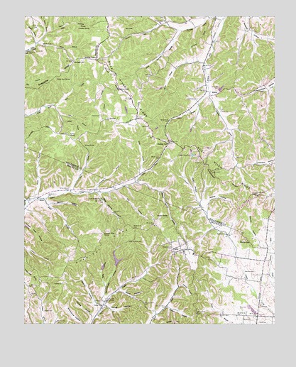
Theta, TN USGS Topographic Map
Click on map above to begin viewing in our Map Viewer.

This topographic map contains these locations and features:
Feature Name Type Latitude Longitude GNIS ID View Map
Adkison CemeteryCemeteryN35.7617°W87.1225°1275492View Map
Andrews CemeteryCemeteryN35.7665°W87.1056°1275739View Map
Anglin BranchStreamN35.8684°W87.1142°1269305View Map
Beckett HillSummitN35.8570°W87.1006°1276737View Map
Bending ChestnutLocaleN35.8584°W87.0889°1276999View Map
BethelPopulated PlaceN35.8015°W87.1183°1277096View Map
Bethel Methodist ChurchChurchN35.8015°W87.1186°1646132View Map
Bethel School (historical)SchoolN35.8012°W87.1200°1646133View Map
Blackburns Mill (historical)LocaleN35.8045°W87.0786°1323668View Map
Blackman CemeteryCemeteryN35.7715°W87.0103°1277609View Map
BostonPopulated PlaceN35.8428°W87.0325°1314718View Map
Boston BranchStreamN35.8428°W87.0331°1278013View Map
Boston Division (historical)CensusN35.8406°W87.0078°1649022View Map
Burnett CemeteryCemeteryN35.7845°W87.0050°1321896View Map
Burns BranchStreamN35.8562°W87.0350°1279084View Map
Carlisle CemeteryCemeteryN35.8348°W87.0872°1279677View Map
Cassman SpringSpringN35.8703°W87.0925°1279857View Map
Cave Spring CemeteryCemeteryN35.8006°W87.0864°1646158View Map
Cave Spring ChurchChurchN35.8009°W87.0870°1305742View Map
Cave Spring HollowValleyN35.8032°W87.0880°1279967View Map
Cave SpringsSpringN35.8006°W87.0871°1646159View Map
Cave Springs School (historical)SchoolN35.8009°W87.0870°1646160View Map
Cedar Grove ChurchChurchN35.8270°W87.1070°1280043View Map
Chestnut RidgeRidgeN35.7826°W87.0858°1280409View Map
Chestnut Ridge ChurchChurchN35.7870°W87.0858°1280421View Map
Commissioner District 6CivilN35.7557°W87.0705°2464559View Map
Cooper HollowValleyN35.7988°W87.1123°1281211View Map
Cunningham RidgeRidgeN35.8601°W87.0506°1312478View Map
Dark HollowValleyN35.8648°W87.1179°1282045View Map
District 19 (historical)CivilN35.7667°W87.0333°1310228View Map
Fairview ChurchChurchN35.7865°W87.0242°1284013View Map
Finnegans KnobSummitN35.8684°W87.0049°2702013View Map
Fitzgerald CemeteryCemeteryN35.7537°W87.0619°1646215View Map
Fox BranchStreamN35.8040°W87.1022°1284759View Map
Galloway CemeteryCemeteryN35.7584°W87.0375°1646228View Map
Garrison CemeteryCemeteryN35.8748°W87.0553°1285210View Map
Garrison ChurchChurchN35.8728°W87.0547°1285212View Map
Garrison CreekStreamN35.8740°W87.0258°1285213View Map
Gaskill CemeteryCemeteryN35.7553°W87.1150°1285222View Map
George HollowValleyN35.7574°W87.0846°1285304View Map
Godwin CemeteryCemeteryN35.7603°W87.0844°1285567View Map
Godwin HollowValleyN35.7561°W87.0883°1285568View Map
Gravel HillSummitN35.7506°W87.0511°1285929View Map
Greenbrier RidgeRidgeN35.8495°W87.1122°1286157View Map
Hatcher MineMineN35.7717°W87.0008°1323705View Map
Hight CemeteryCemeteryN35.7628°W87.1200°1646261View Map
Holt CemeteryCemeteryN35.8512°W87.0622°1288159View Map
Holts ChapelChurchN35.8459°W87.0778°1288173View Map
JamesonPopulated PlaceN35.7531°W87.0089°1313230View Map
Jim HillSummitN35.8703°W87.0725°1289433View Map
John Hunter HollowValleyN35.8744°W87.0358°1289485View Map
Kelley BranchStreamN35.8392°W87.1103°1289997View Map
Litton BranchStreamN35.8351°W87.1072°1291722View Map
Locke BranchStreamN35.8681°W87.1145°1291760View Map
Lockhart CemeteryCemeteryN35.7587°W87.0875°1291776View Map
Loco (historical)Populated PlaceN35.7673°W87.0069°1313237View Map
Lost Acres DamDamN35.7734°W87.0633°1302125View Map
Lost Acres LakeReservoirN35.7734°W87.0633°1302126View Map
Lynn CemeteryCemeteryN35.8273°W87.1036°1292349View Map
Marlin CemeteryCemeteryN35.8367°W87.0272°1292706View Map
McCall LakeReservoirN35.8298°W87.0590°1302160View Map
McCall Lake DamDamN35.8301°W87.0583°1302161View Map
McKee CemeteryCemeteryN35.7523°W87.0158°1306736View Map
McKee HollowValleyN35.7998°W87.0342°1293345View Map
Mill HollowValleyN35.8044°W87.0796°1293873View Map
Mobley CutGapN35.8234°W87.0536°1294127View Map
Moore BranchStreamN35.8642°W87.1192°1294241View Map
Mossy SpringSpringN35.8227°W87.0953°1294523View Map
Mossy Spring SchoolSchoolN35.8267°W87.0975°1294524View Map
Mount Bethel ChurchChurchN35.7856°W87.0556°1294555View Map
Nance BranchStreamN35.8462°W87.0850°1295212View Map
Parham SchoolSchoolN35.8162°W87.0589°1296771View Map
Peach HollowValleyN35.7997°W87.0373°1297045View Map
Pennywinkle HollowValleyN35.7596°W87.0855°1297164View Map
Petty HollowValleyN35.7661°W87.0849°1297279View Map
Pettys BranchStreamN35.7584°W87.0847°1313520View Map
Pine Hill DamDamN35.8451°W87.0300°1302170View Map
Pine Hill LakeReservoirN35.8451°W87.0300°1302171View Map
Poplar Grove Dam Number OneDamN35.8178°W87.0419°1307159View Map
Poplar Grove LakeReservoirN35.8189°W87.0413°1298201View Map
Robinson BranchStreamN35.8428°W87.0331°1269905View Map
Roundtree CemeteryCemeteryN35.7856°W87.0181°1646523View Map
Satlerfield CemeteryCemeteryN35.7853°W87.0131°1322001View Map
Sedberry CemeteryCemeteryN35.8034°W87.0097°1301028View Map
Sedberry CemeteryCemeteryN35.8120°W87.0322°1301029View Map
Sellers HollowValleyN35.7577°W87.0531°1307038View Map
Sewell BranchStreamN35.8009°W87.1175°1301122View Map
Skelly BranchStreamN35.8106°W87.0675°1270425View Map
Skelly HollowValleyN35.7639°W87.0771°1270426View Map
SmardenPopulated PlaceN35.8334°W87.0836°1314303View Map
Smith BranchStreamN35.8009°W87.1156°1270562View Map
Smith BranchStreamN35.8642°W87.1192°1270571View Map
South Garrison BranchStreamN35.8692°W87.0469°1270891View Map
Sparkman BranchStreamN35.8037°W87.0900°1270952View Map
Sparkman CemeteryCemeteryN35.8417°W87.0389°1270953View Map
Stanley HollowValleyN35.7845°W87.0079°1271246View Map
Sulphur SpringSpringN35.7939°W87.0534°1303921View Map
Sulphur Spring BranchStreamN35.8076°W87.0697°1271802View Map
Sulphur Spring HollowValleyN35.8726°W87.0410°1271816View Map
Sulphur Springs (historical)Populated PlaceN35.7940°W87.0519°1646555View Map
Tate CemeteryCemeteryN35.7548°W87.0939°1646556View Map
Taylor ChapelChurchN35.8270°W87.1028°1272223View Map
Terrell CemeteryCemeteryN35.7506°W87.0036°1272331View Map
ThetaPopulated PlaceN35.7787°W87.0503°1304064View Map
Theta Baptist ChurchChurchN35.7795°W87.0456°1646558View Map
Theta CemeteryCemeteryN35.7795°W87.0461°1646559View Map
Theta CemeteryCemeteryN35.7792°W87.0500°1646577View Map
Theta Church of ChristChurchN35.7795°W87.0472°1646560View Map
Theta Community CenterBuildingN35.7781°W87.0444°1646561View Map
Theta School (historical)SchoolN35.7828°W87.0517°1324907View Map
Theta School (historical)SchoolN35.7781°W87.0444°1646562View Map
Theta United Methodist ChurchChurchN35.7787°W87.0494°1646563View Map
Theta Volunteer Fire DepartmentBuildingN35.7783°W87.0444°2653873View Map
Tidwell CemeteryCemeteryN35.8156°W87.0358°1272619View Map
Union ChurchChurchN35.7576°W87.0864°1304227View Map
Union School (historical)SchoolN35.7573°W87.0870°1324909View Map
Walker CemeteryCemeteryN35.7978°W87.0858°1646569View Map
Wall CemeteryCemeteryN35.8306°W87.0669°1273656View Map
Walters HollowValleyN35.7536°W87.0913°1273751View Map
Warren HollowValleyN35.7652°W87.0486°1273838View Map
Yellow Rock SpringSpringN35.8495°W87.1023°1275285View Map

Note: Coordinates in the location and feature list above are referenced to NAD83 datum.


Copyright (C) 2008-2024 Ryan Niemi / Sunset Dynamics ... All Rights Reserved