TopoQuest Logo
Do you find TopoQuest useful?
Help keep TopoQuest running and adding new maps/features by donating!
Bitcoin:  19c7KJd3qBynnjoSw5npx9KScwjBe4ifkT
Litecoin:  LXs6TkuXGGXo1vDsWCkWVdjQX94eUKd6ui
Home View Maps Find Maps Find Places Resources & Links


Thousand Island Lake, Michigan Topographic Map

USGS Map Title: Thousand Island Lake, MI
USGS Map MRC: 46089B4
DRG (GeoTIFF) Download: o46089b4.tif


Neighboring USGS Topographic Map Quads:


  Gogebic, MI  
46089C5


  Tenderfoot Lake, WI  
46089B5
 

  Thousand Island Lake, MI  
46089B4
 

  Black Oak Lake, WI  
46089B3
 

  White Sand Lake, WI  
46089A5
 

  Star Lake, WI  
46089A4
 

  Stormy Lake, WI  
46089A3


Map MRC Location:

N47°
W90°
N47°
W89°
H8 H7 H6 H5 H4 H3 H2 H1
G8 G7 G6 G5 G4 G3 G2 G1
F8 F7 F6 F5 F4 F3 F2 F1
E8 E7 E6 E5 E4 E3 E2 E1
D8 D7 D6 D5 D4 D3 D2 D1
C8 C7 C6 C5 C4 C3 C2 C1
B8 B7 B6 B5 B4 B3 B2 B1
A8 A7 A6 A5 A4 A3 A2 A1
N46°
W90°
N46°
W89°

Thousand Island Lake, MI USGS 1:24K Topographic Map Preview:
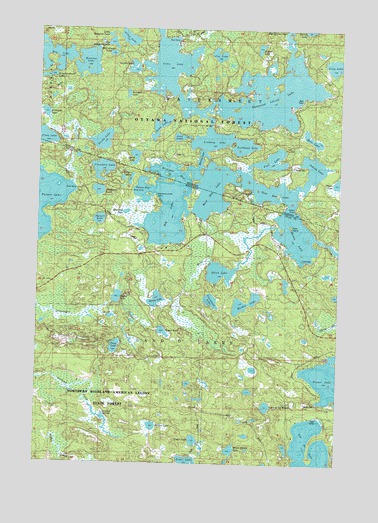
Thousand Island Lake, MI USGS Topographic Map
Click on map above to begin viewing in our Map Viewer.

This topographic map contains these locations and features:
Feature Name Type Latitude Longitude GNIS ID View Map
Balsam LakeLakeN46.1357°W89.4514°1578689View Map
Bay LakeLakeN46.2422°W89.4956°1619116View Map
Belle IslandIslandN46.1938°W89.3982°1578751View Map
Benny LakeLakeN46.1721°W89.4506°1578755View Map
Big LakeLakeN46.2002°W89.4467°1578774View Map
Big Mosquito LakeLakeN46.2459°W89.4705°1619193View Map
Brown LakeLakeN46.2177°W89.4740°1619332View Map
Cedar LakeLakeN46.1318°W89.4340°1578971View Map
Cisco LakeLakeN46.2401°W89.4466°1619509View Map
Cleveland LakeLakeN46.1719°W89.4279°1579018View Map
Coffee LakeLakeN46.1728°W89.4668°1579029View Map
Cox LakeLakeN46.2428°W89.4264°1619600View Map
Crampton LakeLakeN46.2097°W89.4737°1579048View Map
Dalzell LakeLakeN46.1951°W89.4745°1579081View Map
Deadwood LakeLakeN46.2034°W89.4751°1579096View Map
Deerpath LakeLakeN46.1972°W89.4636°1622335View Map
Dream LakeLakeN46.2062°W89.3755°1619762View Map
Dumbbell LakeLakeN46.2312°W89.4636°1619781View Map
Dutch LakeLakeN46.2132°W89.4603°1619788View Map
East Bay LakeLakeN46.2030°W89.4014°1619795View Map
Emeline LakeLakeN46.2401°W89.4804°1619852View Map
Erwin LakeLakeN46.1630°W89.4475°1579215View Map
Fishhawk LakeLakeN46.2165°W89.4150°1619920View Map
Forest LakeLakeN46.1489°W89.3763°1579274View Map
Garland SpringsSpringN46.1380°W89.4726°1579313View Map
Gilbert LakeLakeN46.2066°W89.4620°1579327View Map
Grace LakeLakeN46.2472°W89.4638°1620050View Map
Gray LakeLakeN46.2223°W89.4499°1620070View Map
Guides LakeLakeN46.2380°W89.4610°1620095View Map
Hardin LakeLakeN46.1708°W89.4128°1579389View Map
Helen CreekStreamN46.1907°W89.4088°1579425View Map
Helen LakeLakeN46.1801°W89.4245°1579426View Map
Indian LakeLakeN46.2097°W89.3862°1620298View Map
Indian PointCapeN46.1991°W89.3924°1620305View Map
Jane LakeLakeN46.2189°W89.4418°1620353View Map
Jute Lake Lookout TowerTowerN46.1597°W89.4932°1581241View Map
Kickapoo LakeLakeN46.2255°W89.4977°1620422View Map
Kinwamakwad LakeLakeN46.2359°W89.4992°1620438View Map
Lac du LuneLakeN46.1263°W89.3913°1579613View Map
Lake of the WoodsLakeN46.1417°W89.4042°1580832View Map
Lindsley LakeLakeN46.2181°W89.4285°1620522View Map
Little Mosquito LakeLakeN46.2483°W89.4714°1620568View Map
Mamie LakeLakeN46.1908°W89.3929°1579803View Map
McCullough LakeLakeN46.2428°W89.4704°1620754View Map
Meadowwoods PointCapeN46.2016°W89.4540°1579854View Map
Michigan BayLakeN46.2099°W89.4440°1620804View Map
Midget LakeLakeN46.2448°W89.4089°1620819View Map
Morley LakeLakeN46.2129°W89.4326°1620898View Map
Mule LakeLakeN46.2185°W89.3865°1620948View Map
Ontonagon RiverStreamN46.1617°W89.4623°1580059View Map
Palmer BayBayN46.2030°W89.4599°1580085View Map
Palmer LakeLakeN46.1997°W89.4996°1580086View Map
Perry LakeLakeN46.1586°W89.4676°1580121View Map
Plum CreekStreamN46.2058°W89.4865°1622333View Map
Poor LakeLakeN46.2124°W89.4035°1621286View Map
Spring CreekStreamN46.1862°W89.3755°1580492View Map
Thousand Island LakeLakeN46.2306°W89.4068°1621903View Map
Tower LakeLakeN46.1259°W89.4367°1580631View Map
Town of Land O'LakesCivilN46.1547°W89.3961°1583525View Map
West Bay LakeLakeN46.2042°W89.4261°1580745View Map
White Spruce LakeLakeN46.1294°W89.4210°1580779View Map
Whitefish CreekStreamN46.2044°W89.3764°2099924View Map

Note: Coordinates in the location and feature list above are referenced to NAD83 datum.


Copyright (C) 2008-2024 Ryan Niemi / Sunset Dynamics ... All Rights Reserved