TopoQuest Logo
Do you find TopoQuest useful?
Help keep TopoQuest running and adding new maps/features by donating!
Bitcoin:  19c7KJd3qBynnjoSw5npx9KScwjBe4ifkT
Litecoin:  LXs6TkuXGGXo1vDsWCkWVdjQX94eUKd6ui
Home View Maps Find Maps Find Places Resources & Links


Tilghman, Maryland Topographic Map

USGS Map Title: Tilghman, MD
USGS Map MRC: 38076F3
DRG (GeoTIFF) Download: o38076f3.tif


Neighboring USGS Topographic Map Quads:


  Claiborne, MD  
38076G3
 

  Saint Michaels, MD  
38076G2


  Tilghman, MD  
38076F3
 

  Oxford, MD  
38076F2


Map MRC Location:

N39°
W77°
N39°
W76°
H8 H7 H6 H5 H4 H3 H2 H1
G8 G7 G6 G5 G4 G3 G2 G1
F8 F7 F6 F5 F4 F3 F2 F1
E8 E7 E6 E5 E4 E3 E2 E1
D8 D7 D6 D5 D4 D3 D2 D1
C8 C7 C6 C5 C4 C3 C2 C1
B8 B7 B6 B5 B4 B3 B2 B1
A8 A7 A6 A5 A4 A3 A2 A1
N38°
W77°
N38°
W76°

Tilghman, MD USGS 1:24K Topographic Map Preview:
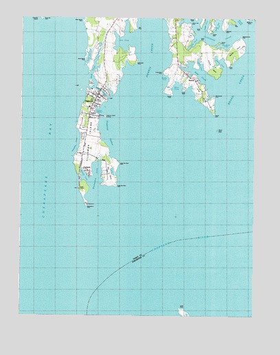
Tilghman, MD USGS Topographic Map
Click on map above to begin viewing in our Map Viewer.

This topographic map contains these locations and features:
Feature Name Type Latitude Longitude GNIS ID View Map
Amys Marsh PointCapeN38.7301°W76.3419°582893View Map
AvalonPopulated PlaceN38.7093°W76.3383°589669View Map
Avalon IslandIslandN38.7087°W76.3302°592649View Map
Back CreekStreamN38.7215°W76.3399°582973View Map
Bald Eagle PointCapeN38.7310°W76.3133°583002View Map
Balls CreekBayN38.7246°W76.2758°583006View Map
Bar NeckCapeN38.6879°W76.3269°583016View Map
Big PointCapeN38.7473°W76.2616°592659View Map
Blackwalnut CoveBayN38.6793°W76.3352°583276View Map
Blackwalnut LandingLocaleN38.6829°W76.3383°592661View Map
Blackwalnut PointCapeN38.6698°W76.3391°583278View Map
Blades PointCapeN38.7496°W76.2819°591802View Map
Boat Point CoveBayN38.7190°W76.3274°592664View Map
Boby Owl CoveBayN38.7471°W76.2702°592665View Map
Broad CreekStreamN38.7062°W76.2580°583404View Map
Bromwell CoveBayN38.7387°W76.2658°592671View Map
Caulk PointCapeN38.7460°W76.2791°592681View Map
Change PointCapeN38.7173°W76.2944°583686View Map
Cherry Tree PointCapeN38.7482°W76.2847°592688View Map
Choptank RiverStreamN38.6346°W76.3266°213797View Map
Choptank RiverStreamN38.6346°W76.3266°583766View Map
Cook PointCapeN38.6287°W76.2888°583875View Map
Cooper PointCapeN38.7440°W76.2730°592703View Map
Deep HarborPopulated PlaceN38.7321°W76.3311°592715View Map
Deep Harbour Farm EstatesPopulated PlaceN38.7321°W76.3269°592716View Map
District 5, Bay HundredCivilN38.7228°W76.3655°1929625View Map
Dogwood HarborBayN38.6982°W76.3247°584121View Map
Dun CoveBayN38.7412°W76.3188°584182View Map
Elston ShoresPopulated PlaceN38.7154°W76.2752°592734View Map
FairbankPopulated PlaceN38.6857°W76.3380°584318View Map
Fairbanks PointCapeN38.7443°W76.2663°592736View Map
Fishing PointCapeN38.7398°W76.2686°592746View Map
Front CreekStreamN38.7304°W76.3408°584525View Map
Green Marsh PointCapeN38.7487°W76.3422°584743View Map
Harris CreekStreamN38.6940°W76.3044°584881View Map
Johns CoveBayN38.7307°W76.2794°592793View Map
Judys PointCapeN38.7410°W76.2786°592794View Map
Knapps NarrowsChannelN38.7193°W76.3319°585327View Map
Leadenham CreekStreamN38.7435°W76.2524°585387View Map
Locust NeckCapeN38.7301°W76.2738°592806View Map
Long CoveBayN38.7396°W76.2830°592808View Map
Long PointCapeN38.7179°W76.2788°592809View Map
Lower Bar Neck PointCapeN38.6793°W76.3233°585618View Map
Meetinghouse PointCapeN38.7423°W76.2577°592822View Map
Middle PointCapeN38.7196°W76.2883°592823View Map
Muddy CoveBayN38.7246°W76.2974°592837View Map
NeavittPopulated PlaceN38.7246°W76.2824°590866View Map
Neavitt ParkParkN38.7279°W76.2888°592844View Map
Neavitt Post OfficePost OfficeN38.7279°W76.2883°595467View Map
Neavitt United Methodist ChurchChurchN38.7265°W76.2863°592845View Map
Nelson Island ShoalBarN38.7029°W76.2699°586164View Map
Nelson PointCapeN38.7096°W76.2716°586166View Map
Old Orchard PointCapeN38.7176°W76.2716°592857View Map
Pawpaw CoveBayN38.6985°W76.3458°586444View Map
Piney PointCapeN38.7298°W76.2655°592875View Map
River CoveBayN38.7207°W76.2919°592894View Map
Saint Johns Chapel CemeteryCemeteryN38.6927°W76.3421°592905View Map
Seth PointCapeN38.7457°W76.3133°587275View Map
South Bar PointCapeN38.7498°W76.3630°587447View Map
Steves CoveBayN38.7315°W76.2686°592940View Map
Talbot County Library - Tilghman BranchBuildingN38.7127°W76.3383°2503681View Map
Talbot County Region V Wastewater Treatment PlantLocaleN38.7149°W76.3397°2503683View Map
TilghmanPopulated PlaceN38.7171°W76.3344°591411View Map
Tilghman Elementary SchoolSchoolN38.7127°W76.3381°592961View Map
Tilghman IslandIslandN38.6957°W76.3369°587801View Map
Tilghman IslandPopulated PlaceN38.7037°W76.3386°1852602View Map
Tilghman Island BeachPopulated PlaceN38.7001°W76.3419°592962View Map
Tilghman Island CemeteryCemeteryN38.7154°W76.3344°592963View Map
Tilghman Island Census Designated PlaceCensusN38.7029°W76.3354°2390388View Map
Tilghman Island LandingLocaleN38.7087°W76.3299°591412View Map
Tilghman Post OfficePost OfficeN38.7104°W76.3386°595474View Map
Tilghman United Methodist ChurchChurchN38.7154°W76.3341°592964View Map
Tilghman Volunteer Fire Company Station 70BuildingN38.7150°W76.3354°2087116View Map
Tilghman Whipp AirportAirportN38.7364°W76.3167°2443782View Map
Turkey Neck PointCapeN38.7273°W76.2986°587911View Map
Upper Bar Neck PointCapeN38.6887°W76.3222°587975View Map
Wells PointCapeN38.7368°W76.2608°592989View Map

Note: Coordinates in the location and feature list above are referenced to NAD83 datum.


Copyright (C) 2008-2024 Ryan Niemi / Sunset Dynamics ... All Rights Reserved