TopoQuest Logo
Do you find TopoQuest useful?
Help keep TopoQuest running and adding new maps/features by donating!
Bitcoin:  19c7KJd3qBynnjoSw5npx9KScwjBe4ifkT
Litecoin:  LXs6TkuXGGXo1vDsWCkWVdjQX94eUKd6ui
Home View Maps Find Maps Find Places Resources & Links


Claiborne, Maryland Topographic Map

USGS Map Title: Claiborne, MD
USGS Map MRC: 38076G3
DRG (GeoTIFF) Download: o38076g3.tif


Neighboring USGS Topographic Map Quads:


  Annapolis, MD  
38076H4
 

  Kent Island, MD  
38076H3
 

  Queenstown, MD  
38076H2


  Claiborne, MD  
38076G3
 

  Saint Michaels, MD  
38076G2


  Tilghman, MD  
38076F3
 

  Oxford, MD  
38076F2


Map MRC Location:

N39°
W77°
N39°
W76°
H8 H7 H6 H5 H4 H3 H2 H1
G8 G7 G6 G5 G4 G3 G2 G1
F8 F7 F6 F5 F4 F3 F2 F1
E8 E7 E6 E5 E4 E3 E2 E1
D8 D7 D6 D5 D4 D3 D2 D1
C8 C7 C6 C5 C4 C3 C2 C1
B8 B7 B6 B5 B4 B3 B2 B1
A8 A7 A6 A5 A4 A3 A2 A1
N38°
W77°
N38°
W76°

Claiborne, MD USGS 1:24K Topographic Map Preview:
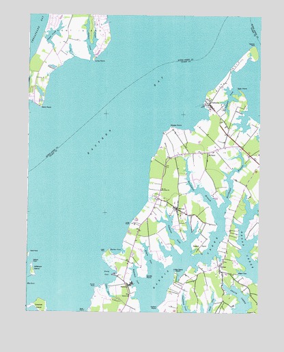
Claiborne, MD USGS Topographic Map
Click on map above to begin viewing in our Map Viewer.

This topographic map contains these locations and features:
Feature Name Type Latitude Longitude GNIS ID View Map
Asbury United Methodist ChurchChurchN38.7943°W76.2941°592646View Map
Asplundh AirportAirportN38.7999°W76.2730°595344View Map
Baie HolmPopulated PlaceN38.8482°W76.3672°596260View Map
Bloody PointCapeN38.8462°W76.3733°597092View Map
BozmanPopulated PlaceN38.7701°W76.2711°589793View Map
Bozman Post OfficePost OfficeN38.7707°W76.2705°595457View Map
Briary CoveBayN38.7737°W76.3094°583376View Map
BrightwoodPopulated PlaceN38.8646°W76.3486°596274View Map
Broad Creek FarmsPopulated PlaceN38.7632°W76.2563°592670View Map
Cabin CoveBayN38.7593°W76.3311°583531View Map
Caulk CoveBayN38.7535°W76.2752°583634View Map
Chews CreekLakeN38.8666°W76.3620°598306View Map
Chews ManorPopulated PlaceN38.8584°W76.3550°596292View Map
ClaibornePopulated PlaceN38.8376°W76.2777°583793View Map
Claiborne Post OfficePost OfficeN38.8368°W76.2752°595458View Map
Claiborne United Methodist ChurchChurchN38.8362°W76.2750°592697View Map
Claiborne-Romancoke Ferry (historical)CrossingN38.8496°W76.3072°598383View Map
Coaches IslandIslandN38.7526°W76.3669°583822View Map
Cove CreekStreamN38.8612°W76.3413°598300View Map
Cove Creek ClubLocaleN38.8668°W76.3369°596300View Map
CrescendoPopulated PlaceN38.7862°W76.2938°592710View Map
CrosswindsPopulated PlaceN38.8646°W76.3577°596303View Map
Cummings CreekBayN38.7832°W76.2952°588764View Map
Eastern BayBayN38.8421°W76.3258°597369View Map
Edgar CoveBayN38.7676°W76.2588°584250View Map
Ferry CoveBayN38.7668°W76.3311°584363View Map
Goat IslandIslandN38.7515°W76.3427°584630View Map
Grace CreekPopulated PlaceN38.7554°W76.2688°592759View Map
Grace CreekBayN38.7543°W76.2583°584683View Map
Great Marsh PointCapeN38.7507°W76.3433°592762View Map
Harbor CoveBayN38.7776°W76.3261°584860View Map
Hidden CreekBayN38.8579°W76.3400°596327View Map
Holligans Snooze InletBayN38.8421°W76.3686°596328View Map
Indian HarborPopulated PlaceN38.7515°W76.2827°592787View Map
Indian PointCapeN38.7529°W76.3033°585136View Map
James ChurchChurchN38.7573°W76.3194°585192View Map
Jefferson IslandIslandN38.7679°W76.3719°585210View Map
John Wesley Methodist Church CemeteryCemeteryN38.8171°W76.2769°592791View Map
John Wesley United Methodist ChurchChurchN38.8173°W76.2769°592792View Map
Kent Fort ManorPopulated PlaceN38.8571°W76.3577°596336View Map
Kent Fort Manor AirportAirportN38.8562°W76.3620°2443780View Map
Kent PointCapeN38.8376°W76.3680°597633View Map
Kent Point FarmPopulated PlaceN38.8418°W76.3733°596340View Map
Kent Point ManorPopulated PlaceN38.8509°W76.3744°596341View Map
Little Neck PointCapeN38.7665°W76.2941°585495View Map
Long PointCapeN38.7873°W76.3188°585591View Map
Long PointCapeN38.8568°W76.3400°597695View Map
Lowes PointCapeN38.7751°W76.3330°585630View Map
Lowes WharfLocaleN38.7654°W76.3286°588516View Map
Mallard PointPopulated PlaceN38.8032°W76.2677°592814View Map
Martin Airport (historical)AirportN38.8012°W76.2563°595345View Map
McDanielPopulated PlaceN38.8176°W76.2780°590773View Map
McDaniel Post OfficePost OfficeN38.8173°W76.2783°595466View Map
McDaniel Station (historical)LocaleN38.8196°W76.2594°592818View Map
Mount PleasantPopulated PlaceN38.7876°W76.2536°592834View Map
Mount Pleasant LandingLocaleN38.7815°W76.2566°592836View Map
North PointCapeN38.7760°W76.3727°586239View Map
North PondHarborN38.8718°W76.3338°593448View Map
Northeast Branch Harris CreekStreamN38.7923°W76.2713°586251View Map
Northwest Branch Harris CreekStreamN38.7923°W76.2713°586259View Map
Nutcracker PointPopulated PlaceN38.8062°W76.2858°592854View Map
Poplar HarborHarborN38.7621°W76.3744°586656View Map
Poplar Island NarrowsChannelN38.7604°W76.3544°588914View Map
Punch PointCapeN38.7618°W76.3375°586723View Map
Rabbit PointCapeN38.7782°W76.2819°586750View Map
Rich NeckCapeN38.8493°W76.2686°586819View Map
Rolles BeachPopulated PlaceN38.7735°W76.2505°592897View Map
Saint James CemeteryCemeteryN38.7569°W76.3198°592904View Map
Saint Johns ChurchChurchN38.8015°W76.3027°587040View Map
Scaffold CreekGutN38.8523°W76.3622°598312View Map
Seth PointCapeN38.8437°W76.2613°587276View Map
SherwoodPopulated PlaceN38.7615°W76.3188°591272View Map
Sherwood Post OfficePost OfficeN38.7618°W76.3208°595472View Map
Sherwood United Methodist ChurchChurchN38.7618°W76.3194°592933View Map
Smith PointCapeN38.7654°W76.3111°587402View Map
Tanners CreekStreamN38.8565°W76.3405°598150View Map
Tanners PointCapeN38.8629°W76.3411°596391View Map
Tilghman CreekBayN38.8401°W76.2669°587800View Map
Tilghman Creek LandingLocaleN38.8354°W76.2688°592960View Map
Tilghman PointCapeN38.8623°W76.2541°587803View Map
Tower Gardens of the BayPopulated PlaceN38.8737°W76.3622°596395View Map
TunisPopulated PlaceN38.8279°W76.2666°592976View Map
Valliant PointCapeN38.7723°W76.3711°587993View Map
Wades PointCapeN38.8276°W76.2975°588014View Map
Waterhole CoveBayN38.7648°W76.3158°588071View Map
Wells CoveBayN38.8721°W76.2760°598231View Map
WittmanPopulated PlaceN38.7937°W76.2941°591579View Map
Wittman ParkParkN38.7929°W76.2961°592996View Map
Wittman Post OfficePost OfficeN38.7937°W76.2941°595479View Map
Wittman SchoolSchoolN38.7843°W76.3150°588307View Map
Wittman School (historical)SchoolN38.7840°W76.3152°592997View Map

Note: Coordinates in the location and feature list above are referenced to NAD83 datum.


Copyright (C) 2008-2025 Ryan Niemi / Sunset Dynamics ... All Rights Reserved