TopoQuest Logo
Do you find TopoQuest useful?
Help keep TopoQuest running and adding new maps/features by donating!
Bitcoin:  19c7KJd3qBynnjoSw5npx9KScwjBe4ifkT
Litecoin:  LXs6TkuXGGXo1vDsWCkWVdjQX94eUKd6ui
Home View Maps Find Maps Find Places Resources & Links


Tinemaha Reservoir, California Topographic Map

USGS Map Title: Tinemaha Reservoir, CA
USGS Map MRC: 37118A2
DRG (GeoTIFF) Download: o37118a2.tif


Neighboring USGS Topographic Map Quads:


  Big Pine, CA  
37118B3
 

  Uhlmeyer Spring, CA  
37118B2
 

  Cowhorn Valley, CA  
37118B1
 

  Fish Springs, CA  
37118A3
 

  Tinemaha Reservoir, CA  
37118A2
 

  Waucoba Mountain, CA  
37118A1
 

  Aberdeen, CA  
36118H3
 

  Blackrock, CA  
36118H2
 

  Mazourka Peak, CA  
36118H1


Map MRC Location:

N38°
W119°
N38°
W118°
H8 H7 H6 H5 H4 H3 H2 H1
G8 G7 G6 G5 G4 G3 G2 G1
F8 F7 F6 F5 F4 F3 F2 F1
E8 E7 E6 E5 E4 E3 E2 E1
D8 D7 D6 D5 D4 D3 D2 D1
C8 C7 C6 C5 C4 C3 C2 C1
B8 B7 B6 B5 B4 B3 B2 B1
A8 A7 A6 A5 A4 A3 A2 A1
N37°
W119°
N37°
W118°

Tinemaha Reservoir, CA USGS 1:24K Topographic Map Preview:
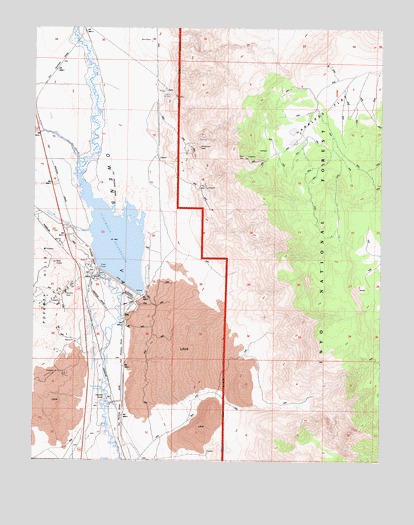
Tinemaha Reservoir, CA USGS Topographic Map
Click on map above to begin viewing in our Map Viewer.

This topographic map contains these locations and features:
Feature Name Type Latitude Longitude GNIS ID View Map
Alice Extension ProspectMineN37.1172°W118.1473°1804609View Map
Alice ProspectMineN37.1180°W118.1501°1804610View Map
Alice Quartz MineMineN37.0852°W118.1887°1804611View Map
Big Pine MineMineN37.1144°W118.1454°1804616View Map
Big Seeley SpringSpringN37.0207°W118.2260°219251View Map
Black Aster ProspectMineN37.0594°W118.1762°1804617View Map
Blake MineMineN37.0880°W118.1757°219434View Map
Blister Lode ProspectMineN37.0974°W118.1790°1804618View Map
Boaz ProspectMineN37.1244°W118.1920°1804619View Map
Bob White ProspectMineN37.1063°W118.1709°1804620View Map
Cabin ProspectMineN37.0994°W118.1529°1804621View Map
Charlies ButteLocaleN37.0152°W118.2315°220923View Map
Contact Silver Number 8 ProspectMineN37.0785°W118.1884°1804622View Map
East Sylvester ProspectMineN37.0669°W118.1709°1804623View Map
Elna (historical)Populated PlaceN37.0938°W118.2245°1703646View Map
Gold Bug ProspectMineN37.0577°W118.1534°1804625View Map
Gold Giant Number 4 MineMineN37.0727°W118.1868°1804626View Map
Green Giant Marble MineMineN37.0794°W118.1904°1804627View Map
Harkless FlatFlatN37.1041°W118.1470°224935View Map
J R Number 2 ProspectMineN37.0991°W118.1684°1804628View Map
Kaweah ProspectMineN37.1197°W118.1518°1804629View Map
Little Seeley SpringSpringN37.0173°W118.2246°227363View Map
Lucky Bee ProspectMineN37.1019°W118.1776°1804630View Map
Lucky Jim ProspectMineN37.0863°W118.1523°1804631View Map
Montezuma MineMineN37.0902°W118.1920°228970View Map
Montezuma South ProspectMineN37.0869°W118.2059°1804633View Map
Mule SpringSpringN37.1060°W118.2015°229314View Map
Mule Springs Number 1 MineMineN37.1066°W118.2032°1804634View Map
New Era MineMineN37.0488°W118.2393°229492View Map
Plain View ProspectMineN37.0791°W118.1518°1804635View Map
Poverty HillsRangeN37.0499°W118.2493°231007View Map
Sangers SloughSwampN37.0851°W118.2332°232531View Map
Tinemaha 6-026 DamDamN37.0552°W118.2270°1663301View Map
Tinemaha CreekStreamN37.0658°W118.2301°236381View Map
Tinemaha ReservoirReservoirN37.0639°W118.2214°236383View Map
Valley View ProspectMineN37.0008°W118.1759°1804636View Map

Note: Coordinates in the location and feature list above are referenced to NAD83 datum.


Copyright (C) 2008-2025 Ryan Niemi / Sunset Dynamics ... All Rights Reserved