TopoQuest Logo
Do you find TopoQuest useful?
Help keep TopoQuest running and adding new maps/features by donating!
Bitcoin:  19c7KJd3qBynnjoSw5npx9KScwjBe4ifkT
Litecoin:  LXs6TkuXGGXo1vDsWCkWVdjQX94eUKd6ui
Home View Maps Find Maps Find Places Resources & Links


Tinnie, New Mexico Topographic Map

USGS Map Title: Tinnie, NM
USGS Map MRC: 33105C2
DRG (GeoTIFF) Download: o33105c2.tif


Neighboring USGS Topographic Map Quads:


  San Patricio, NM  
33105D3
 

  Nelson Canyon West, NM  
33105D2
 

  Nelson Canyon East, NM  
33105D1
 

  Wahalee Canyon, NM  
33105C3
 

  Tinnie, NM  
33105C2
 

  Sunset, NM  
33105C1
 

  Deadman Lake, NM  
33105B3
 

  Flying H NW, NM  
33105B2
 

  Flying H NE, NM  
33105B1


Map MRC Location:

N34°
W106°
N34°
W105°
H8 H7 H6 H5 H4 H3 H2 H1
G8 G7 G6 G5 G4 G3 G2 G1
F8 F7 F6 F5 F4 F3 F2 F1
E8 E7 E6 E5 E4 E3 E2 E1
D8 D7 D6 D5 D4 D3 D2 D1
C8 C7 C6 C5 C4 C3 C2 C1
B8 B7 B6 B5 B4 B3 B2 B1
A8 A7 A6 A5 A4 A3 A2 A1
N33°
W106°
N33°
W105°

Tinnie, NM USGS 1:24K Topographic Map Preview:
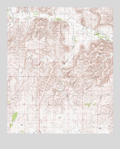
Tinnie, NM USGS Topographic Map
Click on map above to begin viewing in our Map Viewer.

This topographic map contains these locations and features:
Feature Name Type Latitude Longitude GNIS ID View Map
Alamo CanyonValleyN33.3679°W105.2425°903042View Map
Baca Spring CreekStreamN33.3662°W105.2475°903488View Map
Butts PitMineN33.3698°W105.1866°916222View Map
Casey CanyonValleyN33.3526°W105.1655°887257View Map
Chavez CanyonValleyN33.3662°W105.2475°905049View Map
Coyote TankReservoirN33.2555°W105.1396°936876View Map
Diamond A Ranch AirportAirportN33.3372°W105.1742°936993View Map
Divide WellWellN33.2687°W105.1447°900582View Map
First Baptist ChurchChurchN33.3706°W105.2264°901800View Map
Fuller RanchLocaleN33.3390°W105.1719°889262View Map
Galles LakeLakeN33.2586°W105.2316°889297View Map
Galles WellWellN33.2787°W105.2291°889298View Map
Gallo CanyonValleyN33.3154°W105.1844°889307View Map
Goat CanyonValleyN33.3676°W105.2339°889445View Map
Hondo DivisionCivilN33.3265°W105.1425°1937539View Map
Hondo Volunteer Fire DepartmentBuildingN33.3707°W105.2268°2658020View Map
Lincoln County Emergency Medical Services Hondo StationBuildingN33.3708°W105.2267°2657672View Map
Lost LakeLakeN33.2659°W105.1889°891385View Map
PicachoPopulated PlaceN33.3518°W105.1450°899845View Map
Picacho Post OfficePost OfficeN33.3518°W105.1450°937893View Map
Picacho Weather StationLocaleN33.3518°W105.1450°931830View Map
Ridge WellWellN33.2737°W105.1714°893892View Map
Rio Hondo BridgeBridgeN33.3706°W105.2264°934479View Map
River WellWellN33.3545°W105.2014°900581View Map
The SpringSpringN33.3286°W105.1425°898185View Map
TinniePopulated PlaceN33.3706°W105.2264°923707View Map
Tinnie CanyonValleyN33.3701°W105.2172°895695View Map
Tinnie Post OfficePost OfficeN33.3703°W105.2276°2781544View Map
Tinnie Post Office (historical)Post OfficeN33.3706°W105.2264°937544View Map
Trouble WellWellN33.2779°W105.2000°895835View Map

Note: Coordinates in the location and feature list above are referenced to NAD83 datum.


Copyright (C) 2008-2025 Ryan Niemi / Sunset Dynamics ... All Rights Reserved