TopoQuest Logo
Do you find TopoQuest useful?
Help keep TopoQuest running and adding new maps/features by donating!
Bitcoin:  19c7KJd3qBynnjoSw5npx9KScwjBe4ifkT
Litecoin:  LXs6TkuXGGXo1vDsWCkWVdjQX94eUKd6ui
Home View Maps Find Maps Find Places Resources & Links


Tios Creek, Texas Topographic Map

USGS Map Title: Tios Creek, TX
USGS Map MRC: 27099E3
DRG (GeoTIFF) Download: o27099e3.tif


Neighboring USGS Topographic Map Quads:


  Orvil, TX  
27099F4
 

  Cibolo Ranch, TX  
27099F3
 

  Piedra Parada Tank, TX  
27099F2
 

  Laredo East, TX  
27099E4
 

  Tios Creek, TX  
27099E3
 

  Burrito Tank, TX  
27099E2
 

  Laredo South, TX  
27099D4
 

  Blancas Creek North, TX  
27099D3
 

  Retama Creek, TX  
27099D2


Map MRC Location:

N28°
W100°
N28°
W99°
H8 H7 H6 H5 H4 H3 H2 H1
G8 G7 G6 G5 G4 G3 G2 G1
F8 F7 F6 F5 F4 F3 F2 F1
E8 E7 E6 E5 E4 E3 E2 E1
D8 D7 D6 D5 D4 D3 D2 D1
C8 C7 C6 C5 C4 C3 C2 C1
B8 B7 B6 B5 B4 B3 B2 B1
A8 A7 A6 A5 A4 A3 A2 A1
N27°
W100°
N27°
W99°

Tios Creek, TX USGS 1:24K Topographic Map Preview:
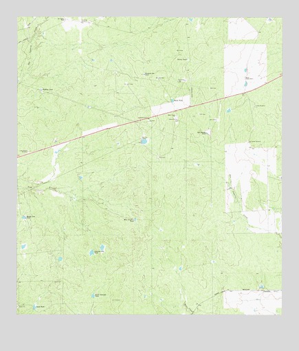
Tios Creek, TX USGS Topographic Map
Click on map above to begin viewing in our Map Viewer.

This topographic map contains these locations and features:
Feature Name Type Latitude Longitude GNIS ID View Map
Bad Bottom TankReservoirN27.5765°W99.2855°1329911View Map
Colorado Flat TankReservoirN27.5265°W99.3399°1333142View Map
Cuates WindmillLocaleN27.5878°W99.2631°1333767View Map
Del Fondo WindmillLocaleN27.5728°W99.2659°1334228View Map
Gault TankReservoirN27.5033°W99.3668°1336447View Map
Highline TankReservoirN27.5948°W99.3641°1337753View Map
House TankReservoirN27.5901°W99.3020°1338157View Map
Huisache WindmillLocaleN27.6231°W99.3453°1338262View Map
KBNL-FM (Laredo)TowerN27.5895°W99.2795°1385908View Map
KVOZ-AM (Laredo)TowerN27.5495°W99.3728°1385611View Map
La Coma Census Designated PlaceCensusN27.5029°W99.3015°2584660View Map
La Coma ColoniaPopulated PlaceN27.5034°W99.3023°2010689View Map
Lake Pasture WindmillLocaleN27.5686°W99.3700°1339509View Map
Middle Tios TankReservoirN27.5409°W99.3720°1341522View Map
Mil Ojos CampLocaleN27.5745°W99.3167°1341585View Map
Mil Ojos Camp LakeReservoirN27.5736°W99.3170°1864755View Map
Mil Ojos Camp Lake DamDamN27.5736°W99.3170°1864754View Map
PescaditoPopulated PlaceN27.5106°W99.2575°1378851View Map
Rancho Corazon NuevoLocaleN27.6003°W99.2681°1344763View Map
San Ygnacio RanchLocaleN27.6242°W99.3525°1346485View Map
South Colorado TankReservoirN27.5076°W99.3393°1347422View Map
West Novillos TankReservoirN27.5402°W99.3195°1349773View Map
Willow TankReservoirN27.6081°W99.2958°1350224View Map
Windmill Pit TankReservoirN27.6014°W99.3156°1350406View Map

Note: Coordinates in the location and feature list above are referenced to NAD83 datum.


Copyright (C) 2008-2025 Ryan Niemi / Sunset Dynamics ... All Rights Reserved