TopoQuest Logo
Do you find TopoQuest useful?
Help keep TopoQuest running and adding new maps/features by donating!
Bitcoin:  19c7KJd3qBynnjoSw5npx9KScwjBe4ifkT
Litecoin:  LXs6TkuXGGXo1vDsWCkWVdjQX94eUKd6ui
Home View Maps Find Maps Find Places Resources & Links


Toppenish, Washington Topographic Map

USGS Map Title: Toppenish, WA
USGS Map MRC: 46120D3
DRG (GeoTIFF) Download: o46120d3.tif


Neighboring USGS Topographic Map Quads:


  Yakima East, WA  
46120E4
 

  Elephant Mountain, WA  
46120E3
 

  Black Rock Spring SW, WA  
46120E2
 

  Wapato, WA  
46120D4
 

  Toppenish, WA  
46120D3
 

  Granger NW, WA  
46120D2
 

  Toppenish SW, WA  
46120C4
 

  Hembre Mountain, WA  
46120C3
 

  Granger, WA  
46120C2


Map MRC Location:

N47°
W121°
N47°
W120°
H8 H7 H6 H5 H4 H3 H2 H1
G8 G7 G6 G5 G4 G3 G2 G1
F8 F7 F6 F5 F4 F3 F2 F1
E8 E7 E6 E5 E4 E3 E2 E1
D8 D7 D6 D5 D4 D3 D2 D1
C8 C7 C6 C5 C4 C3 C2 C1
B8 B7 B6 B5 B4 B3 B2 B1
A8 A7 A6 A5 A4 A3 A2 A1
N46°
W121°
N46°
W120°

Toppenish, WA USGS 1:24K Topographic Map Preview:
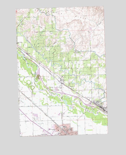
Toppenish, WA USGS Topographic Map
Click on map above to begin viewing in our Map Viewer.

This topographic map contains these locations and features:
Feature Name Type Latitude Longitude GNIS ID View Map
BuenaPopulated PlaceN46.4287°W120.3134°1512046View Map
Buena AirportAirportN46.4439°W120.3404°1533696View Map
Buena Census Designated PlaceCensusN46.4299°W120.3176°2584952View Map
Buena Post OfficePost OfficeN46.4309°W120.3159°2769162View Map
City of ToppenishCivilN46.3806°W120.3124°2412086View Map
City of ZillahCivilN46.4083°W120.2718°2412331View Map
FlintPopulated PlaceN46.4462°W120.3453°1510974View Map
Garfield Elementary SchoolSchoolN46.3771°W120.3188°1530896View Map
Hilton Elementary SchoolSchoolN46.4071°W120.2656°1515267View Map
KeckLocaleN46.4107°W120.2803°1511597View Map
KENE-AM (Toppenish)TowerN46.3757°W120.3228°1534310View Map
Kirkwood Elementary SchoolSchoolN46.3811°W120.3273°1530786View Map
Lincoln Elementary SchoolSchoolN46.3813°W120.3057°1530977View Map
McCoy CemeteryCemeteryN46.3835°W120.2767°1506544View Map
MonteLocaleN46.4187°W120.3728°1514714View Map
Racehorse CanyonValleyN46.4818°W120.2609°1507687View Map
SawyerPopulated PlaceN46.4565°W120.3614°1511293View Map
ToppenishPopulated PlaceN46.3774°W120.3087°1512732View Map
Toppenish High SchoolSchoolN46.3815°W120.3264°1515263View Map
Toppenish Middle SchoolSchoolN46.3833°W120.3133°1515262View Map
Toppenish Police DepartmentBuildingN46.3753°W120.3099°2721934View Map
Toppenish Post OfficePost OfficeN46.3756°W120.3121°2769219View Map
Wasteway 3CanalN46.4810°W120.3503°1509324View Map
Wesley JunctionPopulated PlaceN46.4035°W120.3387°1514879View Map
Yakama Indian Reservation HeadquartersLocaleN46.3762°W120.3378°1509645View Map
Yakama Tribal Police DepartmentBuildingN46.3764°W120.3363°2721884View Map
Yakama Tribal SchoolSchoolN46.3815°W120.3345°1515264View Map
Yakima County Fire District 5 Station 10 ZillahBuildingN46.4012°W120.2590°2619384View Map
Yakima County Fire District 5 Station 7 SawyerBuildingN46.4503°W120.3488°2643449View Map
Yakima County Fire District 5 Station 8 BuenaBuildingN46.4295°W120.3146°2643403View Map
Yakima County Fire District 5 Station 9 ToppenishBuildingN46.3816°W120.3153°2643450View Map
Yakima County Sheriff's OfficeBuildingN46.4255°W120.3138°2722069View Map
ZillahPopulated PlaceN46.4021°W120.2620°1512822View Map
Zillah Fire DepartmentBuildingN46.4012°W120.2590°2619487View Map
Zillah Intermediate SchoolSchoolN46.4045°W120.2650°1515265View Map
Zillah Police DepartmentBuildingN46.4014°W120.2594°2721931View Map
Zillah Post OfficePost OfficeN46.4020°W120.2600°2769218View Map

Note: Coordinates in the location and feature list above are referenced to NAD83 datum.


Copyright (C) 2008-2025 Ryan Niemi / Sunset Dynamics ... All Rights Reserved