TopoQuest Logo
Do you find TopoQuest useful?
Help keep TopoQuest running and adding new maps/features by donating!
Bitcoin:  19c7KJd3qBynnjoSw5npx9KScwjBe4ifkT
Litecoin:  LXs6TkuXGGXo1vDsWCkWVdjQX94eUKd6ui
Home View Maps Find Maps Find Places Resources & Links


Yakima East, Washington Topographic Map

USGS Map Title: Yakima East, WA
USGS Map MRC: 46120E4
DRG (GeoTIFF) Download: o46120e4.tif


Neighboring USGS Topographic Map Quads:


  Selah, WA  
46120F5
 

  Pomona, WA  
46120F4
 

  Selah Springs, WA  
46120F3
 

  Yakima West, WA  
46120E5
 

  Yakima East, WA  
46120E4
 

  Elephant Mountain, WA  
46120E3
 

  Harrah, WA  
46120D5
 

  Wapato, WA  
46120D4
 

  Toppenish, WA  
46120D3


Map MRC Location:

N47°
W121°
N47°
W120°
H8 H7 H6 H5 H4 H3 H2 H1
G8 G7 G6 G5 G4 G3 G2 G1
F8 F7 F6 F5 F4 F3 F2 F1
E8 E7 E6 E5 E4 E3 E2 E1
D8 D7 D6 D5 D4 D3 D2 D1
C8 C7 C6 C5 C4 C3 C2 C1
B8 B7 B6 B5 B4 B3 B2 B1
A8 A7 A6 A5 A4 A3 A2 A1
N46°
W121°
N46°
W120°

Yakima East, WA USGS 1:24K Topographic Map Preview:
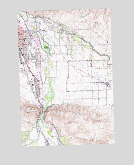
Yakima East, WA USGS Topographic Map
Click on map above to begin viewing in our Map Viewer.

This topographic map contains these locations and features:
Feature Name Type Latitude Longitude GNIS ID View Map
Adams Elementary SchoolSchoolN46.5949°W120.4903°1530780View Map
Ahtanum CreekStreamN46.5310°W120.4731°1515756View Map
American Medical ResponseBuildingN46.5475°W120.4750°2643430View Map
Bethel ChurchChurchN46.5968°W120.4942°1503332View Map
BirchfieldPopulated PlaceN46.5771°W120.4345°1510825View Map
Broadmead Shopping CenterLocaleN46.5787°W120.4892°1513553View Map
Cahalan ParkParkN46.5712°W120.4753°1510598View Map
Cascade Mill PondReservoirN46.6182°W120.4962°1532329View Map
Cascade Mill Pond DamDamN46.6182°W120.4962°1532328View Map
Central Washington FairgroundsLocaleN46.5890°W120.4828°1511657View Map
Childs SchoolSchoolN46.5737°W120.4778°1503962View Map
City of MoxeeCivilN46.5638°W120.3967°2411188View Map
City of Union GapCivilN46.5567°W120.4969°2412131View Map
Country Shopping CenterLocaleN46.5721°W120.4873°1513557View Map
East Valley Central Middle SchoolSchoolN46.5712°W120.4184°1515296View Map
East Valley Central Middle SchoolSchoolN46.5727°W120.4046°1513080View Map
East Valley High SchoolSchoolN46.5710°W120.4178°1515295View Map
First Reformed ChurchChurchN46.5773°W120.4037°1504894View Map
Fullbright ParkParkN46.5387°W120.4834°1510599View Map
Holland CemeteryCemeteryN46.5764°W120.3877°1505559View Map
Holy Rosary SchoolSchoolN46.5571°W120.3817°1505576View Map
Hubbard DitchCanalN46.5935°W120.4442°1511594View Map
Jefferson SchoolSchoolN46.5810°W120.4884°1505797View Map
KBBO-AM (Yakima)TowerN46.5712°W120.4553°1534320View Map
KHYT-FM (Toppenish)TowerN46.5040°W120.3937°1534402View Map
KIHS-FM (Yakima)TowerN46.5312°W120.4506°1534407View Map
KIT-AM (Yakima)TowerN46.5718°W120.4959°1534319View Map
Kiwanis ParkParkN46.6007°W120.4845°1510597View Map
KMWX-AM (Yakima)TowerN46.5579°W120.4517°1534317View Map
KMWX-AM (Yakima)TowerN46.6076°W120.4631°1534318View Map
KRSE-FM (Yakima)TowerN46.5301°W120.4553°1534411View Map
KUTI-AM (Selah)TowerN46.6126°W120.4745°1534297View Map
KXDD-FM (Yakima)TowerN46.5132°W120.4026°1534406View Map
KZTA-AM (Yakima)TowerN46.6132°W120.4820°1534321View Map
Madison SchoolSchoolN46.5993°W120.4995°1506415View Map
Martin Luther King Jr Elementary SchoolSchoolN46.5728°W120.4790°1515289View Map
Mill PondLakeN46.6165°W120.4853°1511604View Map
Mount Hope ChurchChurchN46.5946°W120.4984°1506820View Map
Moxee CanalCanalN46.5957°W120.4409°1511602View Map
Moxee CityPopulated PlaceN46.5537°W120.3831°1512489View Map
Moxee Elementary SchoolSchoolN46.5521°W120.3815°1515293View Map
Moxee Police DepartmentBuildingN46.5565°W120.3915°2722051View Map
Moxee Post OfficePost OfficeN46.5540°W120.3852°2769196View Map
Moxee ValleyValleyN46.5718°W120.4315°1506853View Map
ParkerPopulated PlaceN46.5010°W120.4653°1512547View Map
Parker Census Designated PlaceCensusN46.5022°W120.4668°2585018View Map
Parker Post OfficePost OfficeN46.5041°W120.4680°2769221View Map
Parker StationLocaleN46.5065°W120.4637°1512925View Map
Pioneer CemeteryCemeteryN46.5575°W120.4713°1507459View Map
Roza CanalCanalN46.5818°W120.3895°1513948View Map
Saint Michaels ChurchChurchN46.6032°W120.4987°1508031View Map
Selah Moxee Irrigation CanalCanalN46.6087°W120.4476°1511550View Map
Terrace HeightsPopulated PlaceN46.6062°W120.4398°1511364View Map
Terrace Heights Census Designated PlaceCensusN46.6024°W120.4482°2410069View Map
Terrace Heights Elementary SchoolSchoolN46.6071°W120.4438°1515294View Map
Union GapPopulated PlaceN46.5573°W120.4751°1512750View Map
Union GapGapN46.5321°W120.4698°1509177View Map
Union Gap Police DepartmentBuildingN46.5670°W120.4774°2722022View Map
Union Gap Post OfficePost OfficeN46.5521°W120.4757°2769156View Map
Valley MallLocaleN46.5535°W120.4709°1514620View Map
Wapato DamDamN46.5240°W120.4770°1509285View Map
Washington Middle SchoolSchoolN46.5979°W120.4917°1509302View Map
Washington ParkPopulated PlaceN46.5968°W120.4881°1510657View Map
Wide Hollow CreekStreamN46.5373°W120.4706°1528119View Map
Yakima County Fire District 4 East Valley Fire Department Station 40BuildingN46.5722°W120.4033°2619525View Map
Yakima County Fire District 4 East Valley Fire Department Station 41BuildingN46.5550°W120.3858°2619850View Map
Yakima County Fire District 4 East Valley Fire Department Station 42BuildingN46.6075°W120.4467°2619531View Map
Yakima County Fire District 5 Station 5 ParkerBuildingN46.5015°W120.4670°2643402View Map
Yakima County Sheriff's OfficeBuildingN46.5760°W120.4918°2721987View Map
Yakima Fire Department Station 95BuildingN46.5856°W120.4903°2643455View Map
Yakima Fire Department Station 96 Union Gap Fire DepartmentBuildingN46.5575°W120.4772°2619395View Map
Yakima Sportsmen State ParkParkN46.5910°W120.4578°1513493View Map
Yakima Town and Country ClubLocaleN46.5998°W120.4320°1533269View Map

Note: Coordinates in the location and feature list above are referenced to NAD83 datum.


Copyright (C) 2008-2024 Ryan Niemi / Sunset Dynamics ... All Rights Reserved