TopoQuest Logo
Do you find TopoQuest useful?
Help keep TopoQuest running and adding new maps/features by donating!
Bitcoin:  19c7KJd3qBynnjoSw5npx9KScwjBe4ifkT
Litecoin:  LXs6TkuXGGXo1vDsWCkWVdjQX94eUKd6ui
Home View Maps Find Maps Find Places Resources & Links


Touch-Me-Not Mountain, New Mexico Topographic Map

USGS Map Title: Touch-Me-Not Mountain, NM
USGS Map MRC: 36105E2
DRG (GeoTIFF) Download: o36105e2.tif


Neighboring USGS Topographic Map Quads:


  Red River Pass, NM  
36105F3
 

  Baldy Mountain, NM  
36105F2
 

  Abreu Canyon, NM  
36105F1
 

  Eagle Nest, NM  
36105E3
 

  Touch-Me-Not Mountain, NM  
36105E2
 

  Ute Park, NM  
36105E1
 

  Palo Flechado Pass, NM  
36105D3
 

  Garcia Peak, NM  
36105D2
 

  Tooth of Time, NM  
36105D1


Map MRC Location:

N37°
W106°
N37°
W105°
H8 H7 H6 H5 H4 H3 H2 H1
G8 G7 G6 G5 G4 G3 G2 G1
F8 F7 F6 F5 F4 F3 F2 F1
E8 E7 E6 E5 E4 E3 E2 E1
D8 D7 D6 D5 D4 D3 D2 D1
C8 C7 C6 C5 C4 C3 C2 C1
B8 B7 B6 B5 B4 B3 B2 B1
A8 A7 A6 A5 A4 A3 A2 A1
N36°
W106°
N36°
W105°

Touch-Me-Not Mountain, NM USGS 1:24K Topographic Map Preview:
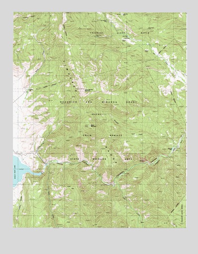
Touch-Me-Not Mountain, NM USGS Topographic Map
Click on map above to begin viewing in our Map Viewer.

This topographic map contains these locations and features:
Feature Name Type Latitude Longitude GNIS ID View Map
Ajax MineMineN36.6053°W105.2294°914602View Map
AlabamaMineN36.6067°W105.1686°914603View Map
AllenLocaleN36.5806°W105.1256°915779View Map
American FlagMineN36.6167°W105.2478°915696View Map
Aristocrat MineMineN36.6120°W105.2403°939751View Map
Arlington MineMineN36.6206°W105.2300°921064View Map
Atmore RanchLocaleN36.5875°W105.1328°885940View Map
Big Mike MineMineN36.6120°W105.2403°939668View Map
Black Horse GroupMineN36.6173°W105.1981°915720View Map
Black TailMineN36.6086°W105.2336°915655View Map
Bobtail MineMineN36.6123°W105.2495°939742View Map
Brilliant MineMineN36.6134°W105.2228°939737View Map
Bull of the Woods MineMineN36.6217°W105.2000°915718View Map
Cimarron Canyon State ParkParkN36.5370°W105.1517°902100View Map
Cimarron Canyon Wildlife AreaParkN36.5528°W105.1742°887608View Map
Cincinnati MineMineN36.6206°W105.2300°939733View Map
Clear CreekStreamN36.5275°W105.1764°887670View Map
Clear Creek StoreLocaleN36.5261°W105.1767°887671View Map
Colin Neblett State Wildlife AreaParkN36.5459°W105.1867°901702View Map
Eagle Nest DamDamN36.5334°W105.2339°924132View Map
Eagle Nest LodgeLocaleN36.5425°W105.2442°888613View Map
Eleanor MineMineN36.6214°W105.2192°940037View Map
Euclid MineMineN36.6214°W105.2192°939715View Map
Faro Banks MineMineN36.6167°W105.2392°939717View Map
Florence MineMineN36.6206°W105.2300°940014View Map
Gold DollarMineN36.6100°W105.2317°915710View Map
Good Fairy MineMineN36.6217°W105.2000°940016View Map
Good FriendMineN36.6236°W105.2147°915708View Map
Grand Duchess MineMineN36.6167°W105.2392°939708View Map
Grand View MineMineN36.6134°W105.2228°939709View Map
Grand View Number 3 MineMineN36.6134°W105.2228°939710View Map
Gravel Pit LakesLakeN36.5460°W105.1352°889565View Map
Grey Eagle Number Two MineMineN36.6134°W105.2228°940000View Map
Grub Flat MineMineN36.6206°W105.2300°940017View Map
Heart of the World MineMineN36.6120°W105.2403°940019View Map
Helen GouldMineN36.6117°W105.2358°915705View Map
Helen MineMineN36.6048°W105.2256°939707View Map
Hidden Treasure MineMineN36.6114°W105.2411°917164View Map
Horseshoe MineMineN36.5384°W105.1983°890194View Map
Independence Number 4 MineMineN36.6206°W105.2300°939702View Map
Independence Number 6 MineMineN36.6228°W105.1931°939703View Map
Indiana MineMineN36.6206°W105.2300°939704View Map
Iron Mask MineMineN36.6123°W105.2495°939705View Map
Isabella B MineMineN36.6134°W105.2228°939706View Map
J V C MineMineN36.6167°W105.2392°939434View Map
Jackson CemeteryCemeteryN36.5906°W105.1286°890393View Map
Jennings MineMineN36.6048°W105.2256°939436View Map
Kensington MineMineN36.6134°W105.2228°939699View Map
Lake AspenLakeN36.6099°W105.1658°885927View Map
Lake DorisLakeN36.6110°W105.1673°888466View Map
Legal Tender MineMineN36.6084°W105.2278°915704View Map
Lexington MineMineN36.6120°W105.2403°939438View Map
Little Wonder MineMineN36.6134°W105.2228°939442View Map
Louisville Number 2 MineMineN36.6123°W105.2495°939444View Map
Maverick CreekStreamN36.5470°W105.1322°891686View Map
Metropole MineMineN36.6167°W105.2392°940001View Map
Montezuma MineMineN36.6228°W105.1931°915723View Map
Mount Lion Number 2 MineMineN36.6206°W105.2300°939669View Map
Mountain Queen Number 1 MineMineN36.6167°W105.2392°939663View Map
Mountain Queen Number 2 MineMineN36.6167°W105.2392°939664View Map
Mountain View Number 1 MineMineN36.6100°W105.2292°939748View Map
Nancy Hanks Number 2 MineMineN36.6167°W105.2392°939670View Map
New Mexican MineMineN36.6120°W105.2403°939672View Map
North Star MineMineN36.6120°W105.2403°939741View Map
Onion MineMineN36.6134°W105.2228°939673View Map
Only Chance MineMineN36.6100°W105.2292°939675View Map
Ophia MineMineN36.6206°W105.2300°939736View Map
PalisadesCliffN36.5381°W105.1564°902506View Map
Paragon ClaimMineN36.6217°W105.2081°915658View Map
Pay MineMineN36.6020°W105.2328°915717View Map
Perryville (historical)Populated PlaceN36.5361°W105.2275°902068View Map
Perryville Post Office (historical)Post OfficeN36.5361°W105.2275°938312View Map
Pink CheekMineN36.6061°W105.2364°915661View Map
Real MineMineN36.6228°W105.1931°939727View Map
Rebel Chief MineMineN36.6189°W105.1872°915663View Map
Rebel Chief PlacerMineN36.6200°W105.1803°915714View Map
Royal Flush MineMineN36.6120°W105.2403°940034View Map
Senate MineMineN36.6123°W105.2495°940035View Map
Showman MineMineN36.6100°W105.2292°939721View Map
Snow Bird MineMineN36.6100°W105.2292°940038View Map
Tolby CreekStreamN36.5364°W105.2253°895728View Map
Touch-Me-Not MountainSummitN36.5809°W105.1992°895777View Map
Virginia CityPopulated PlaceN36.5798°W105.2400°901843View Map
Virginia CityLocaleN36.5828°W105.2372°896162View Map
Virginia Post Office (historical)Post OfficeN36.5828°W105.2372°937719View Map
Willow MineMineN36.6206°W105.2300°939445View Map
Woodland MineMineN36.6214°W105.2192°939447View Map
WyanodotteMineN36.6045°W105.2297°915698View Map

Note: Coordinates in the location and feature list above are referenced to NAD83 datum.


Copyright (C) 2008-2025 Ryan Niemi / Sunset Dynamics ... All Rights Reserved