TopoQuest Logo
Do you find TopoQuest useful?
Help keep TopoQuest running and adding new maps/features by donating!
Bitcoin:  19c7KJd3qBynnjoSw5npx9KScwjBe4ifkT
Litecoin:  LXs6TkuXGGXo1vDsWCkWVdjQX94eUKd6ui
Home View Maps Find Maps Find Places Resources & Links


Red River Pass, New Mexico Topographic Map

USGS Map Title: Red River Pass, NM
USGS Map MRC: 36105F3
DRG (GeoTIFF) Download: o36105f3.tif


Neighboring USGS Topographic Map Quads:


  Latir Peak, NM  
36105G4
 

  Comanche Point, NM  
36105G3
 

  Ash Mountain, NM  
36105G2
 

  Red River, NM  
36105F4
 

  Red River Pass, NM  
36105F3
 

  Baldy Mountain, NM  
36105F2
 

  Wheeler Peak, NM  
36105E4
 

  Eagle Nest, NM  
36105E3
 

  Touch-Me-Not Mountain, NM  
36105E2


Map MRC Location:

N37°
W106°
N37°
W105°
H8 H7 H6 H5 H4 H3 H2 H1
G8 G7 G6 G5 G4 G3 G2 G1
F8 F7 F6 F5 F4 F3 F2 F1
E8 E7 E6 E5 E4 E3 E2 E1
D8 D7 D6 D5 D4 D3 D2 D1
C8 C7 C6 C5 C4 C3 C2 C1
B8 B7 B6 B5 B4 B3 B2 B1
A8 A7 A6 A5 A4 A3 A2 A1
N36°
W106°
N36°
W105°

Red River Pass, NM USGS 1:24K Topographic Map Preview:
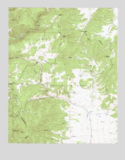
Red River Pass, NM USGS Topographic Map
Click on map above to begin viewing in our Map Viewer.

This topographic map contains these locations and features:
Feature Name Type Latitude Longitude GNIS ID View Map
Big Bobcat CreekStreamN36.6970°W105.2792°903778View Map
Bitter Creek Mining CompanyMineN36.7309°W105.3422°917758View Map
Black Copper GroupMineN36.6381°W105.3714°917778View Map
Black MountainSummitN36.7053°W105.2633°903885View Map
Black WizardMineN36.6517°W105.3500°917896View Map
Blacksmith CanyonValleyN36.6859°W105.2750°903905View Map
Bobcat PassGapN36.7000°W105.3397°903977View Map
Boston Queen ProspectMineN36.7220°W105.3711°917816View Map
Butcherknife CanyonValleyN36.6803°W105.3406°904253View Map
ChallengeMineN36.6611°W105.3525°916090View Map
Cora GibsonMineN36.7345°W105.3419°917817View Map
Costilla PassGapN36.7281°W105.2900°905390View Map
Deldosso ProspectMineN36.7464°W105.3319°917819View Map
Ditch Cabin ParkFlatN36.7075°W105.2556°905778View Map
Elizabeth MineMineN36.6723°W105.3550°916101View Map
ElladoraMineN36.6711°W105.3414°916102View Map
EmeraldMineN36.6836°W105.3497°916500View Map
Enchanted Forest Cross Country Ski AreaLocaleN36.6983°W105.3569°2678235View Map
Enderman ProspectMineN36.7295°W105.3467°917747View Map
EnterpriseMineN36.6692°W105.3511°916104View Map
Foster ParkParkN36.6623°W105.3639°906344View Map
Free GoldMineN36.6836°W105.3506°916497View Map
Gem Number TwoMineN36.6253°W105.2517°916492View Map
Gold BellMineN36.6623°W105.3483°916494View Map
Gold King Number TwoMineN36.6595°W105.3456°916112View Map
Gold LeafMineN36.6314°W105.3431°916113View Map
Green MeadowsAreaN36.6881°W105.2917°906734View Map
HarmonMineN36.6436°W105.3417°916115View Map
HeckLocaleN36.6673°W105.3089°924839View Map
Hematite (historical)Populated PlaceN36.6536°W105.3589°932876View Map
Hematite CreekStreamN36.6684°W105.3267°906924View Map
Hematite ParkFlatN36.6536°W105.3589°906925View Map
Hematite Post Office (historical)Post OfficeN36.6536°W105.3589°937404View Map
Hemitite ChiefMineN36.6673°W105.3486°916488View Map
Hidden TreasureMineN36.6645°W105.3475°916489View Map
Hollenback CreekStreamN36.6298°W105.2822°907027View Map
HuntingtoniaMineN36.6495°W105.3486°916118View Map
IndependenceMineN36.6581°W105.3431°916119View Map
Independence MineMineN36.7417°W105.3369°917792View Map
Iron BirdMineN36.6606°W105.3483°916481View Map
Italian ParkFlatN36.6759°W105.3622°907265View Map
Jacks and Sixes GroupMineN36.7095°W105.3567°917796View Map
Kentucky ParkFlatN36.6517°W105.3442°907540View Map
King Yellow JacketMineN36.6709°W105.3383°916485View Map
Labor ExchangeMineN36.6634°W105.3481°916479View Map
Little Bobcat CreekStreamN36.6798°W105.3389°907996View Map
ManzanitaMineN36.6578°W105.3447°916127View Map
MemphisLocaleN36.7328°W105.3422°908570View Map
Memphis MineMineN36.7331°W105.3414°917800View Map
Mill CreekStreamN36.6528°W105.2853°908743View Map
MiseryMineN36.6578°W105.3458°917892View Map
MonitorMineN36.6659°W105.3497°917893View Map
Moreno (historical)Populated PlaceN36.6536°W105.2825°902066View Map
Moreno RanchLocaleN36.6536°W105.2825°908900View Map
Mud GulchValleyN36.6475°W105.2842°908938View Map
Mutz RanchLocaleN36.6314°W105.3011°908995View Map
NeptuneMineN36.7334°W105.3436°917836View Map
North Moreno CreekStreamN36.6545°W105.2853°909173View Map
O KMineN36.6589°W105.3417°917900View Map
OttumayMineN36.6578°W105.3408°916515View Map
Pine GulchValleyN36.6259°W105.2561°909668View Map
PrichardMineN36.6325°W105.3372°916510View Map
Red River PassGapN36.6800°W105.3703°910075View Map
RoyalMineN36.6600°W105.3414°916095View Map
Silver Queen ProspectMineN36.7331°W105.3439°916660View Map
Spring GulchValleyN36.6403°W105.2844°911332View Map
Taos MountainsRangeN36.7445°W105.3722°928823View Map
Tetilla PeakSummitN36.7236°W105.3122°911616View Map
TyrolerMineN36.6731°W105.3567°916111View Map
Van Diest PeakSummitN36.7434°W105.3164°912070View Map
Varida GroupMineN36.7403°W105.3422°916654View Map

Note: Coordinates in the location and feature list above are referenced to NAD83 datum.


Copyright (C) 2008-2025 Ryan Niemi / Sunset Dynamics ... All Rights Reserved