TopoQuest Logo
Do you find TopoQuest useful?
Help keep TopoQuest running and adding new maps/features by donating!
Bitcoin:  19c7KJd3qBynnjoSw5npx9KScwjBe4ifkT
Litecoin:  LXs6TkuXGGXo1vDsWCkWVdjQX94eUKd6ui
Home View Maps Find Maps Find Places Resources & Links


Trenton, Texas Topographic Map

USGS Map Title: Trenton, TX
USGS Map MRC: 33096D3
DRG (GeoTIFF) Download: o33096d3.tif


Neighboring USGS Topographic Map Quads:


  Whitewright, TX  
33096E4
 

  Ector, TX  
33096E3
 

  Bonham, TX  
33096E2
 

  Pilot Grove, TX  
33096D4
 

  Trenton, TX  
33096D3
 

  Leonard, TX  
33096D2
 

  Blue Ridge, TX  
33096C4
 

  Pike, TX  
33096C3
 

  Celeste, TX  
33096C2


Map MRC Location:

N34°
W97°
N34°
W96°
H8 H7 H6 H5 H4 H3 H2 H1
G8 G7 G6 G5 G4 G3 G2 G1
F8 F7 F6 F5 F4 F3 F2 F1
E8 E7 E6 E5 E4 E3 E2 E1
D8 D7 D6 D5 D4 D3 D2 D1
C8 C7 C6 C5 C4 C3 C2 C1
B8 B7 B6 B5 B4 B3 B2 B1
A8 A7 A6 A5 A4 A3 A2 A1
N33°
W97°
N33°
W96°

Trenton, TX USGS 1:24K Topographic Map Preview:
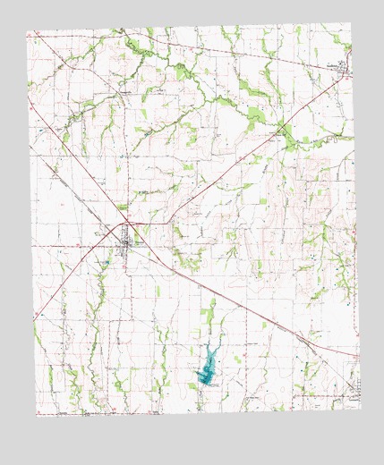
Trenton, TX USGS Topographic Map
Click on map above to begin viewing in our Map Viewer.

This topographic map contains these locations and features:
Feature Name Type Latitude Longitude GNIS ID View Map
Bailey CemeteryCemeteryN33.3898°W96.3472°1351409View Map
Blanton ChapelChurchN33.3971°W96.2933°1352407View Map
Blanton CreekStreamN33.4757°W96.3069°1352408View Map
Brushy CreekStreamN33.4615°W96.2714°1353040View Map
Burns CemeteryCemeteryN33.4373°W96.3211°1353357View Map
Casey FieldAirportN33.3757°W96.3194°1387073View Map
Chinquapin CreekStreamN33.4912°W96.3300°1354444View Map
Church of ChristChurchN33.4293°W96.3389°2018902View Map
City of TrentonCivilN33.4269°W96.3411°2412092View Map
Cottonwood CreekStreamN33.4598°W96.2761°1355082View Map
DelbaPopulated PlaceN33.3751°W96.3311°1379648View Map
East Shady Grove ChurchChurchN33.3796°W96.2950°1356703View Map
Foster Valley CreekStreamN33.4476°W96.2930°1357620View Map
Gods Delight LakeReservoirN33.4468°W96.2686°1864703View Map
Gods Delight Lake DamDamN33.4468°W96.2686°1864702View Map
Indian Creek ChurchChurchN33.3751°W96.3564°1359942View Map
Leonard CemeteryCemeteryN33.3817°W96.2540°2769950View Map
NobilityPopulated PlaceN33.3759°W96.3664°1380256View Map
OrangevillePopulated PlaceN33.4784°W96.3397°1380309View Map
Pace CreekStreamN33.4673°W96.2789°1364677View Map
Porter CreekStreamN33.4898°W96.3211°1365603View Map
RandolphPopulated PlaceN33.4840°W96.2525°1366003View Map
Randolph Fire DepartmentBuildingN33.4847°W96.2539°2655389View Map
Randolph Post OfficePost OfficeN33.4850°W96.2567°2731640View Map
Red Wing AirportAirportN33.4603°W96.3494°1387652View Map
Rock CreekStreamN33.4990°W96.3380°1366646View Map
Soil Conservation Service Site 38 DamDamN33.3784°W96.3586°1855019View Map
Soil Conservation Service Site 38 ReservoirReservoirN33.3784°W96.3586°1855020View Map
Soil Conservation Service Site 39 DamDamN33.3768°W96.3503°1855017View Map
Soil Conservation Service Site 39 ReservoirReservoirN33.3768°W96.3503°1855018View Map
Soil Conservation Service Site 45 DamDamN33.3851°W96.3103°1855021View Map
Soil Conservation Service Site 45 ReservoirReservoirN33.3851°W96.3103°1855022View Map
Texas No Name Number 36 DamDamN33.4318°W96.2669°1864701View Map
Thornton LakeReservoirN33.3865°W96.3093°1369868View Map
TrentonPopulated PlaceN33.4307°W96.3386°1370102View Map
Trenton City HallBuildingN33.4312°W96.3402°2753171View Map
Trenton Elementary SchoolSchoolN33.4273°W96.3410°2005805View Map
Trenton High SchoolSchoolN33.4104°W96.3365°2005806View Map
Trenton Police DepartmentBuildingN33.4312°W96.3401°2751372View Map
Trenton Post OfficePost OfficeN33.4311°W96.3395°2732215View Map
Union HillPopulated PlaceN33.4643°W96.2808°1380698View Map
Valley Creek ChurchChurchN33.4218°W96.2519°1370551View Map

Note: Coordinates in the location and feature list above are referenced to NAD83 datum.


Copyright (C) 2008-2024 Ryan Niemi / Sunset Dynamics ... All Rights Reserved