TopoQuest Logo
Do you find TopoQuest useful?
Help keep TopoQuest running and adding new maps/features by donating!
Bitcoin:  19c7KJd3qBynnjoSw5npx9KScwjBe4ifkT
Litecoin:  LXs6TkuXGGXo1vDsWCkWVdjQX94eUKd6ui
Home View Maps Find Maps Find Places Resources & Links


Trinidad East, Colorado Topographic Map

USGS Map Title: Trinidad East, CO
USGS Map MRC: 37104B4
DRG (GeoTIFF) Download: o37104b4.tif


Neighboring USGS Topographic Map Quads:


  Ludlow, CO  
37104C5
 

  Hoehne, CO  
37104C4
 

  Earl, CO  
37104C3
 

  Trinidad West, CO  
37104B5
 

  Trinidad East, CO  
37104B4
 

  Mooney Hills, CO  
37104B3
 

  Starkville, CO  
37104A5
 

  Fishers Peak, CO  
37104A4
 

  Barela, CO  
37104A3


Map MRC Location:

N38°
W105°
N38°
W104°
H8 H7 H6 H5 H4 H3 H2 H1
G8 G7 G6 G5 G4 G3 G2 G1
F8 F7 F6 F5 F4 F3 F2 F1
E8 E7 E6 E5 E4 E3 E2 E1
D8 D7 D6 D5 D4 D3 D2 D1
C8 C7 C6 C5 C4 C3 C2 C1
B8 B7 B6 B5 B4 B3 B2 B1
A8 A7 A6 A5 A4 A3 A2 A1
N37°
W105°
N37°
W104°

Trinidad East, CO USGS 1:24K Topographic Map Preview:
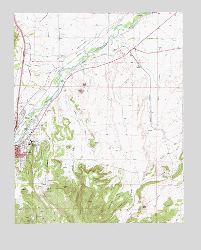
Trinidad East, CO USGS Topographic Map
Click on map above to begin viewing in our Map Viewer.

This topographic map contains these locations and features:
Feature Name Type Latitude Longitude GNIS ID View Map
Ave Maria ShrineChurchN37.1714°W104.4869°194734View Map
BeshoarPopulated PlaceN37.2181°W104.4066°194730View Map
Chilili DitchCanalN37.2111°W104.4619°194728View Map
China CanyonValleyN37.1560°W104.4568°194742View Map
China CreekStreamN37.1872°W104.4528°194743View Map
City of TrinidadCivilN37.1748°W104.4907°2412094View Map
Cordova CemeteryCemeteryN37.1700°W104.4289°194737View Map
Duran ArroyoStreamN37.2214°W104.3900°194747View Map
Eagle RockPillarN37.1345°W104.4053°194745View Map
East Street SchoolSchoolN37.1711°W104.4961°194735View Map
El MoroPopulated PlaceN37.2245°W104.4666°194727View Map
El Moro Census Designated PlaceCensusN37.2349°W104.4492°2583233View Map
Engle MineMineN37.1461°W104.4825°1735206View Map
EnglevillePopulated PlaceN37.1495°W104.4753°194739View Map
Engleville CanyonValleyN37.1737°W104.4742°194751View Map
Engleville CemeteryCemeteryN37.1506°W104.4760°2750949View Map
Engleville MineMineN37.1453°W104.4767°194740View Map
Frijole HillSummitN37.1545°W104.3880°194746View Map
Garcia CemeteryCemeteryN37.1837°W104.4810°194732View Map
Gray CreekStreamN37.2067°W104.4675°194754View Map
Helen MineMineN37.1822°W104.4992°1735821View Map
Highland MineMineN37.1470°W104.4636°1735210View Map
Highline MineMineN37.1467°W104.4639°194741View Map
Hospital CanyonValleyN37.1759°W104.4860°194738View Map
Las Animas County FairgroundsLocaleN37.1908°W104.4997°2357369View Map
Las Animas County JailBuildingN37.1827°W104.4852°2696641View Map
Las Animas County Sheriff's OfficeBuildingN37.1825°W104.4852°2696620View Map
Mike Gagliardi DamDamN37.2334°W104.4089°199144View Map
Mike Gagliardi ReservoirReservoirN37.2337°W104.4081°199145View Map
Mount San Rafael HeliportAirportN37.1875°W104.4880°204606View Map
Mount San Rafael HospitalHospitalN37.1732°W104.4876°194733View Map
Nile CanyonValleyN37.1420°W104.4138°194752View Map
Number Six CanyonValleyN37.1497°W104.4183°194744View Map
Picketwire DitchCanalN37.2328°W104.4733°203734View Map
Pio HillSummitN37.1745°W104.4736°194736View Map
Pioneer Ditch Number 1CanalN37.1379°W104.4120°2724009View Map
Powell ArroyoStreamN37.1936°W104.4789°194722View Map
Rivera CemeteryCemeteryN37.2332°W104.4247°194729View Map
Trinidad Ambulance DistrictBuildingN37.1830°W104.4852°2695580View Map
Trinidad DivisionCivilN37.1574°W104.4398°1935585View Map
Trinidad Police DepartmentBuildingN37.1827°W104.4852°2696656View Map
Trinidad Police Department JailBuildingN37.1828°W104.4847°2696640View Map
Valdez CemeteryCemeteryN37.2039°W104.4636°194731View Map
Welte PitMineN37.1286°W104.4889°1735822View Map

Note: Coordinates in the location and feature list above are referenced to NAD83 datum.


Copyright (C) 2008-2025 Ryan Niemi / Sunset Dynamics ... All Rights Reserved