TopoQuest Logo
Do you find TopoQuest useful?
Help keep TopoQuest running and adding new maps/features by donating!
Bitcoin:  19c7KJd3qBynnjoSw5npx9KScwjBe4ifkT
Litecoin:  LXs6TkuXGGXo1vDsWCkWVdjQX94eUKd6ui
Home View Maps Find Maps Find Places Resources & Links


Truxton, Missouri Topographic Map

USGS Map Title: Truxton, MO
USGS Map MRC: 39091A2
DRG (GeoTIFF) Download: o39091a2.tif


Neighboring USGS Topographic Map Quads:


  New Hartford, MO  
39091B3
 

  Louisville, MO  
39091B2
 

  Eolia, MO  
39091B1
 

  Bellflower North, MO  
39091A3
 

  Truxton, MO  
39091A2
 

  Silex, MO  
39091A1
 

  Bellflower South, MO  
38091H3
 

  Hawk Point, MO  
38091H2
 

  Warrenton NE, MO  
38091H1


Map MRC Location:

N40°
W92°
N40°
W91°
H8 H7 H6 H5 H4 H3 H2 H1
G8 G7 G6 G5 G4 G3 G2 G1
F8 F7 F6 F5 F4 F3 F2 F1
E8 E7 E6 E5 E4 E3 E2 E1
D8 D7 D6 D5 D4 D3 D2 D1
C8 C7 C6 C5 C4 C3 C2 C1
B8 B7 B6 B5 B4 B3 B2 B1
A8 A7 A6 A5 A4 A3 A2 A1
N39°
W92°
N39°
W91°

Truxton, MO USGS 1:24K Topographic Map Preview:
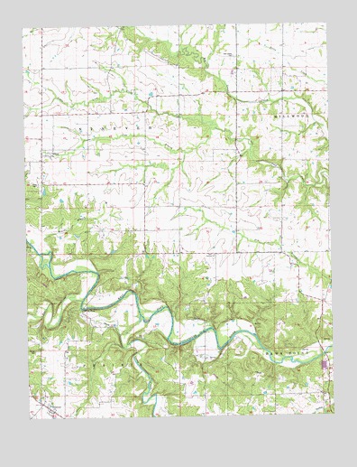
Truxton, MO USGS Topographic Map
Click on map above to begin viewing in our Map Viewer.

This topographic map contains these locations and features:
Feature Name Type Latitude Longitude GNIS ID View Map
Abe Duff School (historical)SchoolN39.0738°W91.1490°742435View Map
Bear CreekStreamN39.0374°W91.2275°713803View Map
Beck School (historical)SchoolN39.0250°W91.2260°742437View Map
Blair (historical)BuildingN39.0384°W91.1385°740148View Map
Bracht BranchStreamN39.0534°W91.2407°714603View Map
Camp CreekStreamN39.0322°W91.2038°731547View Map
Duncan School (historical)SchoolN39.0750°W91.2010°742434View Map
FairviewPopulated PlaceN39.0356°W91.1835°740576View Map
Fairview ChurchChurchN39.0514°W91.1732°735613View Map
Fairview Post Office (historical)Post OfficeN39.0356°W91.1835°760135View Map
Grimmett School (historical)SchoolN39.1192°W91.2415°742431View Map
Koala-T FieldAirportN39.0419°W91.1304°2679342View Map
Lost BranchStreamN39.0920°W91.1718°730135View Map
Millsap BridgeBridgeN39.0348°W91.2271°755320View Map
Millsup Ford (historical)LocaleN39.0348°W91.2274°735370View Map
Old Liberty CemeteryCemeteryN39.1148°W91.1638°723759View Map
OlneyPopulated PlaceN39.0839°W91.2432°735769View Map
Olney CemeteryCemeteryN39.0748°W91.2451°723816View Map
Owings CemeteryCemeteryN39.0214°W91.2471°723914View Map
Palmer School (historical)SchoolN39.0400°W91.1376°742438View Map
Patterson School (historical)SchoolN39.1162°W91.2132°742432View Map
Pine Knott School (historical)SchoolN39.0028°W91.2164°737819View Map
Reddish School (historical)SchoolN39.1103°W91.1618°742433View Map
Rocky Point School (historical)SchoolN39.0467°W91.1868°742436View Map
Starkey HollowValleyN39.0217°W91.1546°738291View Map
Township of NinevehCivilN39.0879°W91.2076°766907View Map
Township of PrairieCivilN39.0187°W91.2233°766908View Map
TruxtonPopulated PlaceN39.0020°W91.2399°727820View Map
Truxton CemeteryCemeteryN39.0049°W91.2403°2585200View Map
Truxton Post OfficePost OfficeN39.0030°W91.2411°2782732View Map
Truxton School (historical)SchoolN39.0042°W91.2418°754912View Map
Village of TruxtonCivilN39.0035°W91.2403°2400007View Map

Note: Coordinates in the location and feature list above are referenced to NAD83 datum.


Copyright (C) 2008-2025 Ryan Niemi / Sunset Dynamics ... All Rights Reserved