TopoQuest Logo
Do you find TopoQuest useful?
Help keep TopoQuest running and adding new maps/features by donating!
Bitcoin:  19c7KJd3qBynnjoSw5npx9KScwjBe4ifkT
Litecoin:  LXs6TkuXGGXo1vDsWCkWVdjQX94eUKd6ui
Home View Maps Find Maps Find Places Resources & Links


Tularosa, New Mexico Topographic Map

USGS Map Title: Tularosa, NM
USGS Map MRC: 33106A1
DRG (GeoTIFF) Download: o33106a1.tif


Neighboring USGS Topographic Map Quads:


  Bitter Creek, NM  
33106B2
 

  Tularosa NE, NM  
33106B1
 

  Cat Mountain, NM  
33105B8


  Tularosa, NM  
33106A1
 

  Sabinata Flat, NM  
33105A8


  Malone Draw, NM  
32106H1
 

  Alamogordo North, NM  
32105H8


Map MRC Location:

N34°
W107°
N34°
W106°
H8 H7 H6 H5 H4 H3 H2 H1
G8 G7 G6 G5 G4 G3 G2 G1
F8 F7 F6 F5 F4 F3 F2 F1
E8 E7 E6 E5 E4 E3 E2 E1
D8 D7 D6 D5 D4 D3 D2 D1
C8 C7 C6 C5 C4 C3 C2 C1
B8 B7 B6 B5 B4 B3 B2 B1
A8 A7 A6 A5 A4 A3 A2 A1
N33°
W107°
N33°
W106°

Tularosa, NM USGS 1:24K Topographic Map Preview:
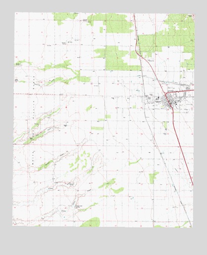
Tularosa, NM USGS Topographic Map
Click on map above to begin viewing in our Map Viewer.

This topographic map contains these locations and features:
Feature Name Type Latitude Longitude GNIS ID View Map
10016 Water WellWellN33.1162°W106.0333°926387View Map
10017 Water WellWellN33.1015°W106.0328°926614View Map
10018 Water WellWellN33.0779°W106.0403°926381View Map
10021 Water WellWellN33.0776°W106.0930°926622View Map
10023 Water WellWellN33.0959°W106.0117°926612View Map
10025 Water WellWellN33.0856°W106.0169°926382View Map
10027 Water WellWellN33.0695°W106.0080°926620View Map
10029 Water WellWellN33.0559°W106.0203°926376View Map
10030 Water WellWellN33.0462°W106.0380°926627View Map
10033 Water WellWellN33.0404°W106.0275°926626View Map
10034 Water WellWellN33.0243°W106.0164°926624View Map
10106 Water WellWellN33.1117°W106.0650°926616View Map
10107 Water WellWellN33.0915°W106.0753°926386View Map
10111 Water WellWellN33.0906°W106.0594°926385View Map
10114 Water WellWellN33.0756°W106.0372°926621View Map
10119 Water WellWellN33.0684°W106.0380°926618View Map
10125 Water WellWellN33.0662°W106.0455°926617View Map
10129 Water WellWellN33.0684°W106.0644°926619View Map
10131 Water WellWellN33.0543°W106.0639°926375View Map
10133 Water WellWellN33.0606°W106.0419°926377View Map
10134 Water WellWellN33.0920°W106.0117°926611View Map
10138 Water WellWellN33.0881°W106.0100°926383View Map
10141 Water WellWellN33.0612°W106.0030°926379View Map
10143 Water WellWellN33.0606°W106.0011°926378View Map
10294 Water WellWellN33.0618°W106.0336°926380View Map
10301 Water WellWellN33.0390°W106.0242°926625View Map
10314 Water WellWellN33.1026°W106.0494°926615View Map
Aguilar WellWellN33.0518°W106.1136°901048View Map
Beckett Farm AirportAirportN33.0566°W106.0248°2444040View Map
Berral WellWellN33.0384°W106.0458°886247View Map
Brazel SpringSpringN33.0947°W106.1216°901028View Map
Calvary Baptist ChurchChurchN33.0740°W106.0186°920975View Map
Church of Christ churchChurchN33.0740°W106.0186°920290View Map
Church of the NazareneChurchN33.0740°W106.0186°920244View Map
Clayton WellWellN33.0404°W106.0280°887668View Map
First Baptist ChurchChurchN33.0906°W106.0186°921241View Map
French SpringSpringN33.0312°W106.1205°889231View Map
Jack Rabbit Flats Volunteer Fire DepartmentBuildingN33.0588°W106.0633°2657909View Map
Kenny WellWellN33.0915°W106.0750°890670View Map
Lomitas Ranch (historical)LocaleN33.1215°W106.0778°901325View Map
Lomitas SpringSpringN33.1206°W106.0780°891263View Map
Mesquite SpringSpringN33.0243°W106.0828°891908View Map
Purday RanchLocaleN33.0920°W106.0755°901280View Map
Purday RanchLocaleN33.0768°W106.0889°893560View Map
Round Mountain SpringSpringN33.0331°W106.1128°894184View Map
Saint Francis de PaulaChurchN33.0743°W106.0183°901958View Map
Scholler SpringSpringN33.0906°W106.0894°900408View Map
Sheep Camp SpringsSpringN33.0121°W106.0823°894771View Map
Sidwell WellWellN33.0598°W106.0878°894829View Map
South SpringSpringN33.0854°W106.1214°900407View Map
Tecolote CanyonValleyN33.1065°W106.0042°900970View Map
The Gospel TabernacleChurchN33.0740°W106.0186°920159View Map
TularosaPopulated PlaceN33.0740°W106.0186°899964View Map
TularosaBuildingN33.0740°W106.0186°929484View Map
Tularosa High SchoolSchoolN33.0740°W106.0186°914670View Map
Tularosa Historical MarkerParkN33.0740°W106.0186°932287View Map
Tularosa Middle SchoolSchoolN33.0740°W106.0186°914671View Map
Tularosa Original Townsite Historic DistrictLocaleN33.0740°W106.0186°934431View Map
Tularosa Police DepartmentBuildingN33.0729°W106.0185°2722619View Map
Tularosa Post OfficePost OfficeN33.0740°W106.0186°937808View Map
Tularosa Volunteer Fire DepartmentBuildingN33.0737°W106.0188°2657741View Map
Tularosa Water WellWellN33.0987°W106.0811°926613View Map
Tularosa Weather StationLocaleN33.0740°W106.0186°931861View Map
Village of TularosaCivilN33.0752°W106.0175°2413595View Map

Note: Coordinates in the location and feature list above are referenced to NAD83 datum.


Copyright (C) 2008-2024 Ryan Niemi / Sunset Dynamics ... All Rights Reserved