TopoQuest Logo
Do you find TopoQuest useful?
Help keep TopoQuest running and adding new maps/features by donating!
Bitcoin:  19c7KJd3qBynnjoSw5npx9KScwjBe4ifkT
Litecoin:  LXs6TkuXGGXo1vDsWCkWVdjQX94eUKd6ui
Home View Maps Find Maps Find Places Resources & Links


Tullos, Louisiana Topographic Map

USGS Map Title: Tullos, LA
USGS Map MRC: 31092G3
DRG (GeoTIFF) Download: o31092g3.tif


Neighboring USGS Topographic Map Quads:


  Flat Creek, LA  
31092H4
 

  Olla West, LA  
31092H3
 

  Olla East, LA  
31092H2
 

  Georgetown, LA  
31092G4
 

  Tullos, LA  
31092G3
 

  Summerville, LA  
31092G2
 

  Mudville, LA  
31092F4
 

  Little Creek, LA  
31092F3
 

  Jena West, LA  
31092F2


Map MRC Location:

N32°
W93°
N32°
W92°
H8 H7 H6 H5 H4 H3 H2 H1
G8 G7 G6 G5 G4 G3 G2 G1
F8 F7 F6 F5 F4 F3 F2 F1
E8 E7 E6 E5 E4 E3 E2 E1
D8 D7 D6 D5 D4 D3 D2 D1
C8 C7 C6 C5 C4 C3 C2 C1
B8 B7 B6 B5 B4 B3 B2 B1
A8 A7 A6 A5 A4 A3 A2 A1
N31°
W93°
N31°
W92°

Tullos, LA USGS 1:24K Topographic Map Preview:
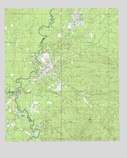
Tullos, LA USGS Topographic Map
Click on map above to begin viewing in our Map Viewer.

This topographic map contains these locations and features:
Feature Name Type Latitude Longitude GNIS ID View Map
Bay Springs Lookout TowerTowerN31.7693°W92.2821°545895View Map
Castor CreekStreamN31.7966°W92.3624°558187View Map
Castor Salt LickLocaleN31.8385°W92.3643°549523View Map
Chickasaw CreekStreamN31.8604°W92.3238°546360View Map
Cochran CreekStreamN31.8018°W92.3576°554030View Map
Doughty CemeteryCemeteryN31.7879°W92.3132°546368View Map
Drake CreekStreamN31.7938°W92.3368°546371View Map
Dugdemona RiverStreamN31.7960°W92.3626°554294View Map
Georgetown Water SupplyReservoirN31.7552°W92.3668°556714View Map
Georgetown Water Supply DamDamN31.7552°W92.3668°556713View Map
GrandstaffPopulated PlaceN31.7746°W92.3629°546378View Map
Grant (historical)Populated PlaceN31.7554°W92.3454°545804View Map
Hardtner Medical CenterHospitalN31.8605°W92.2758°545924View Map
Hardtner Medical Center HeliportAirportN31.8613°W92.2760°1632970View Map
LaSalle Junior High SchoolSchoolN31.8695°W92.2941°545935View Map
Little Chickasaw CreekStreamN31.8399°W92.2754°546392View Map
Magnolia CemeteryCemeteryN31.8252°W92.3460°555213View Map
Mountain HillSummitN31.7696°W92.2826°543497View Map
New Union CemeteryCemeteryN31.8202°W92.3021°545950View Map
New Union CreekStreamN31.7988°W92.3260°546398View Map
New Union Missionary Baptist ChurchChurchN31.8193°W92.3018°555488View Map
Parish Governing Authority District 3CivilN31.8093°W92.2682°1929960View Map
Pendarvis CemeteryCemeteryN31.8341°W92.3343°546406View Map
Pendarvis LandingLocaleN31.8304°W92.3410°545972View Map
RochellePopulated PlaceN31.7902°W92.3696°546409View Map
Saline CreekStreamN31.8321°W92.3421°547946View Map
Sandy CreekStreamN31.7938°W92.3129°546412View Map
Tarver CreekStreamN31.8521°W92.2593°546416View Map
Town of TullosCivilN31.8188°W92.3293°2406763View Map
Town of UraniaCivilN31.8639°W92.2912°2406781View Map
TullosPopulated PlaceN31.8193°W92.3299°546417View Map
Tullos Elementary School (historical)SchoolN31.8202°W92.3279°545984View Map
Tullos Post OfficePost OfficeN31.8179°W92.3304°1630394View Map
Tullos School (historical)SchoolN31.8079°W92.3126°545985View Map
Tullos Urania Oil FieldOilfieldN31.8229°W92.3124°556276View Map
Tullos Volunteer Fire DepartmentBuildingN31.8178°W92.3305°2672937View Map
UraniaPopulated PlaceN31.8638°W92.2960°556315View Map
Urania CemeteryCemeteryN31.8643°W92.2899°545986View Map
Urania Elementary SchoolSchoolN31.8696°W92.2943°545987View Map
Urania High School (historical)SchoolN31.8699°W92.2943°545988View Map
Urania Post OfficePost OfficeN31.8635°W92.2951°1630395View Map
Urania Volunteer Fire DepartmentBuildingN31.8641°W92.2960°2672811View Map
Ward ThreeCivilN31.8407°W92.3115°546423View Map
Waterhole BranchStreamN31.8416°W92.2893°546418View Map
Wayside ChurchChurchN31.8499°W92.2832°546419View Map

Note: Coordinates in the location and feature list above are referenced to NAD83 datum.


Copyright (C) 2008-2025 Ryan Niemi / Sunset Dynamics ... All Rights Reserved