TopoQuest Logo
Do you find TopoQuest useful?
Help keep TopoQuest running and adding new maps/features by donating!
Bitcoin:  19c7KJd3qBynnjoSw5npx9KScwjBe4ifkT
Litecoin:  LXs6TkuXGGXo1vDsWCkWVdjQX94eUKd6ui
Home View Maps Find Maps Find Places Resources & Links


Olla East, Louisiana Topographic Map

USGS Map Title: Olla East, LA
USGS Map MRC: 31092H2
DRG (GeoTIFF) Download: o31092h2.tif


Neighboring USGS Topographic Map Quads:


  Cotton Plant, LA  
32092A3
 

  Clark, LA  
32092A2
 

  Columbia, LA  
32092A1
 

  Olla West, LA  
31092H3
 

  Olla East, LA  
31092H2
 

  Holum, LA  
31092H1
 

  Tullos, LA  
31092G3
 

  Summerville, LA  
31092G2
 

  Nickel, LA  
31092G1


Map MRC Location:

N32°
W93°
N32°
W92°
H8 H7 H6 H5 H4 H3 H2 H1
G8 G7 G6 G5 G4 G3 G2 G1
F8 F7 F6 F5 F4 F3 F2 F1
E8 E7 E6 E5 E4 E3 E2 E1
D8 D7 D6 D5 D4 D3 D2 D1
C8 C7 C6 C5 C4 C3 C2 C1
B8 B7 B6 B5 B4 B3 B2 B1
A8 A7 A6 A5 A4 A3 A2 A1
N31°
W93°
N31°
W92°

Olla East, LA USGS 1:24K Topographic Map Preview:
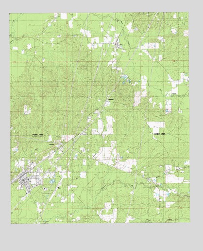
Olla East, LA USGS Topographic Map
Click on map above to begin viewing in our Map Viewer.

This topographic map contains these locations and features:
Feature Name Type Latitude Longitude GNIS ID View Map
Banister CreekStreamN31.9877°W92.2493°532303View Map
Bear BranchStreamN31.8771°W92.2257°532826View Map
Benson CemeteryCemeteryN31.9654°W92.2271°532950View Map
Blake CemeteryCemeteryN31.8974°W92.1532°545902View Map
Brown CemeteryCemeteryN31.9768°W92.1940°533436View Map
Caldwell Parish District 1BuildingN31.9811°W92.1755°2672950View Map
Chickasaw Creek Gas FieldOilfieldN31.9024°W92.1374°545911View Map
Davis (historical)Populated PlaceN31.9013°W92.1521°1630377View Map
Davis CemeteryCemeteryN31.9974°W92.2193°534406View Map
Good Hope Baptist Church (historical)ChurchN31.9366°W92.1557°542396View Map
Good Hope CemeteryCemeteryN31.9368°W92.1560°535268View Map
Hargrove CemeteryCemeteryN31.9713°W92.2037°535525View Map
Harris Chapel (historical)ChurchN31.9018°W92.1529°545925View Map
Harris Chapel CemeteryCemeteryN31.9082°W92.1462°535542View Map
KellyPopulated PlaceN31.9807°W92.1768°536160View Map
Kelly Baptist ChurchChurchN31.9807°W92.1743°542404View Map
Kelly Elementary SchoolSchoolN31.9796°W92.1742°542405View Map
Kelly Post OfficePost OfficeN31.9807°W92.1760°1630054View Map
Kelly SchoolSchoolN31.9824°W92.2168°536165View Map
LaSalle High SchoolSchoolN31.8978°W92.2423°545934View Map
McDaniel CemeteryCemeteryN31.9668°W92.2010°536979View Map
Mill PondReservoirN31.9175°W92.2185°545941View Map
North Rabbit Branch Gas FieldOilfieldN31.9479°W92.1265°542415View Map
North Standard Gas FieldsOilfieldN31.9557°W92.1765°542416View Map
OllaPopulated PlaceN31.9029°W92.2432°555561View Map
Olla AirportAirportN31.8989°W92.2150°1632902View Map
Olla CemeteryCemeteryN31.9015°W92.2482°545955View Map
Olla Police DepartmentBuildingN31.9033°W92.2412°2755258View Map
Olla Standard Elementary SchoolSchoolN31.9114°W92.2346°545956View Map
Olla Volunteer Fire Department Station 1BuildingN31.8992°W92.2310°2672922View Map
Olla Volunteer Fire Department Station 2BuildingN31.9169°W92.2466°2672973View Map
Olla-Standard High School (historical)SchoolN31.9113°W92.2349°545957View Map
Pleasant Ridge Baptist ChurchChurchN31.8979°W92.1524°555685View Map
Rabbit BranchStreamN31.8979°W92.1579°538458View Map
Saint Joseph CemeteryCemeteryN31.9338°W92.2124°538910View Map
SpauldingPopulated PlaceN31.9477°W92.1826°543688View Map
Spaulding Gas FieldOilfieldN31.9343°W92.2168°542427View Map
StandardPopulated PlaceN31.9177°W92.2201°539619View Map
Standard Baptist ChurchChurchN31.9179°W92.2137°545973View Map
Standard Gas FieldOilfieldN31.9202°W92.1960°545974View Map
Standard School (historical)SchoolN31.9135°W92.2112°545975View Map
Tidwell CemeteryCemeteryN31.9415°W92.1396°556241View Map
Town of OllaCivilN31.8981°W92.2404°2407046View Map
Ward TwoCivilN31.8916°W92.2443°545105View Map

Note: Coordinates in the location and feature list above are referenced to NAD83 datum.


Copyright (C) 2008-2024 Ryan Niemi / Sunset Dynamics ... All Rights Reserved