TopoQuest Logo
Do you find TopoQuest useful?
Help keep TopoQuest running and adding new maps/features by donating!
Bitcoin:  19c7KJd3qBynnjoSw5npx9KScwjBe4ifkT
Litecoin:  LXs6TkuXGGXo1vDsWCkWVdjQX94eUKd6ui
Home View Maps Find Maps Find Places Resources & Links


Tumble Mountain, Montana Topographic Map

USGS Map Title: Tumble Mountain, MT
USGS Map MRC: 45110C1
DRG (GeoTIFF) Download: o45110c1.tif


Neighboring USGS Topographic Map Quads:


  Chrome Mountain, MT  
45110D2
 

  Picket Pin Mountain, MT  
45110D1
 

  Meyer Mountain, MT  
45109D8
 

  Mount Douglas, MT  
45110C2
 

  Tumble Mountain, MT  
45110C1
 

  Cathedral Point, MT  
45109C8
 

  Haystack Peak, MT  
45110B2
 

  Pinnacle Mountain, MT  
45110B1
 

  Little Park Mountain, MT  
45109B8


Map MRC Location:

N46°
W111°
N46°
W110°
H8 H7 H6 H5 H4 H3 H2 H1
G8 G7 G6 G5 G4 G3 G2 G1
F8 F7 F6 F5 F4 F3 F2 F1
E8 E7 E6 E5 E4 E3 E2 E1
D8 D7 D6 D5 D4 D3 D2 D1
C8 C7 C6 C5 C4 C3 C2 C1
B8 B7 B6 B5 B4 B3 B2 B1
A8 A7 A6 A5 A4 A3 A2 A1
N45°
W111°
N45°
W110°

Tumble Mountain, MT USGS 1:24K Topographic Map Preview:
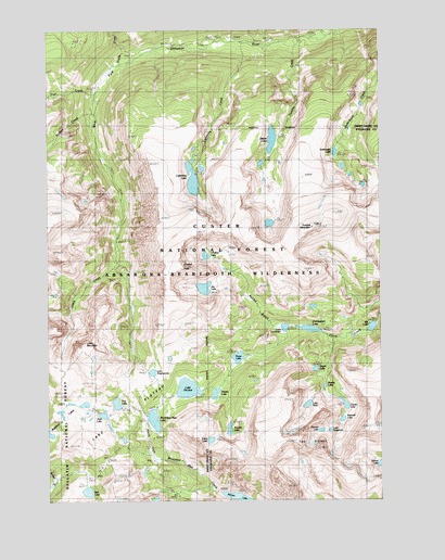
Tumble Mountain, MT USGS Topographic Map
Click on map above to begin viewing in our Map Viewer.

This topographic map contains these locations and features:
Feature Name Type Latitude Longitude GNIS ID View Map
Asteroid LakeLakeN45.2715°W110.0152°806058View Map
Barrier LakeLakeN45.2507°W110.0544°806073View Map
Bill LakeLakeN45.2961°W110.0038°806063View Map
Chalice LakeLakeN45.3151°W110.0661°806076View Map
Chalice PeakSummitN45.3122°W110.0744°781144View Map
Cimmerian LakeLakeN45.2956°W110.0277°781277View Map
Clam LakeLakeN45.2661°W110.0648°806071View Map
Comet LakeLakeN45.2756°W110.0143°806059View Map
Crescent CreekStreamN45.3735°W110.0194°781879View Map
Divide CreekStreamN45.3660°W110.0985°782405View Map
Dreary LakeLakeN45.2783°W110.0628°806066View Map
Dryad LakeLakeN45.2849°W110.0253°806062View Map
Fish LakeLakeN45.2526°W110.1111°783437View Map
Hermit LakeLakeN45.2686°W110.0232°806057View Map
Hidden CreekStreamN45.3530°W110.1077°784822View Map
Jasper LakeLakeN45.3457°W110.0411°806077View Map
Jay LakeLakeN45.3065°W110.0668°806075View Map
Lake DiaphanousLakeN45.2842°W110.0866°806069View Map
Lake MountainSummitN45.2902°W110.1119°785920View Map
Lake PinchotLakeN45.2798°W110.0734°788869View Map
Lake PisceLakeN45.2755°W110.0283°806060View Map
Lake PlateauPlainN45.2760°W110.1116°785923View Map
Lake SurrenderLakeN45.2959°W110.0369°806064View Map
Lake VengenceLakeN45.2687°W110.0199°806056View Map
Lewis CreekStreamN45.3133°W110.0996°806074View Map
Lightning CreekStreamN45.3716°W110.0507°786106View Map
Lightning LakeLakeN45.3349°W110.0709°806078View Map
Needle LakeLakeN45.2804°W110.0218°806061View Map
Owl LakeLakeN45.2760°W110.1000°806072View Map
Pipit LakeLakeN45.2729°W110.1051°806070View Map
Rabbit GulchValleyN45.2969°W110.0405°789313View Map
Ravin LakeLakeN45.2880°W110.0546°806067View Map
Saderbalm LakeLakeN45.3424°W110.0176°806068View Map
Trail CreekStreamN45.3580°W110.1074°792311View Map
Trouble LakeLakeN45.2690°W110.0577°806065View Map
Tumble CreekStreamN45.3727°W110.0296°792443View Map
Tumble MountainSummitN45.3227°W110.0255°792446View Map
Two SistersSummitN45.2638°W110.0235°792560View Map
Wounded Man LakeLakeN45.2717°W110.0860°793551View Map

Note: Coordinates in the location and feature list above are referenced to NAD83 datum.


Copyright (C) 2008-2025 Ryan Niemi / Sunset Dynamics ... All Rights Reserved