TopoQuest Logo
Do you find TopoQuest useful?
Help keep TopoQuest running and adding new maps/features by donating!
Bitcoin:  19c7KJd3qBynnjoSw5npx9KScwjBe4ifkT
Litecoin:  LXs6TkuXGGXo1vDsWCkWVdjQX94eUKd6ui
Home View Maps Find Maps Find Places Resources & Links


Bluff Lake, Mississippi Topographic Map

USGS Map Title: Bluff Lake, MS
USGS Map MRC: 33088C7
DRG (GeoTIFF) Download: o33088c7.tif


Neighboring USGS Topographic Map Quads:


  Longview, MS  
33088D8
 

  Starkville, MS  
33088D7
 

  Artesia, MS  
33088D6
 

  Bradley, MS  
33088C8
 

  Bluff Lake, MS  
33088C7
 

  Crawford West, MS  
33088C6
 

  Betheden, MS  
33088B8
 

  Barge Lake, MS  
33088B7
 

  Lynn Creek, MS  
33088B6


Map MRC Location:

N34°
W89°
N34°
W88°
H8 H7 H6 H5 H4 H3 H2 H1
G8 G7 G6 G5 G4 G3 G2 G1
F8 F7 F6 F5 F4 F3 F2 F1
E8 E7 E6 E5 E4 E3 E2 E1
D8 D7 D6 D5 D4 D3 D2 D1
C8 C7 C6 C5 C4 C3 C2 C1
B8 B7 B6 B5 B4 B3 B2 B1
A8 A7 A6 A5 A4 A3 A2 A1
N33°
W89°
N33°
W88°

Bluff Lake, MS USGS 1:24K Topographic Map Preview:
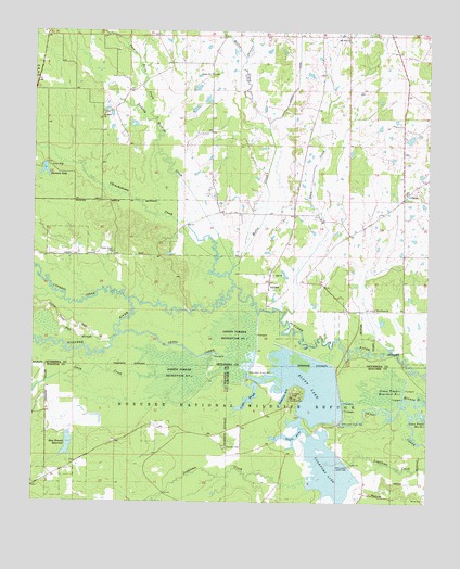
Bluff Lake, MS USGS Topographic Map
Click on map above to begin viewing in our Map Viewer.

This topographic map contains these locations and features:
Feature Name Type Latitude Longitude GNIS ID View Map
Bethel Baptist ChurchChurchN33.3637°W88.8189°666933View Map
Bethel CemeteryCemeteryN33.3635°W88.8185°682888View Map
Bluff LakeReservoirN33.2814°W88.7884°667335View Map
Bluff Lake DamDamN33.2735°W88.7767°681966View Map
Boyles Mill (historical)LocaleN33.2698°W88.7601°689656View Map
Cedar Grove (historical)LocaleN33.3154°W88.8501°682896View Map
Cedar Grove Baptist ChurchChurchN33.3160°W88.8495°682897View Map
Cedar Grove CemeteryCemeteryN33.3165°W88.8498°668190View Map
Chinchahoma CreekStreamN33.3107°W88.8128°692893View Map
Community Club CemeteryCemeteryN33.3304°W88.7556°682911View Map
Community Club ChurchChurchN33.3315°W88.7576°682912View Map
Council Ridge (historical)LocaleN33.2887°W88.7584°705751View Map
Cypress CreekStreamN33.3040°W88.8442°693036View Map
Dickerson ArmBayN33.2790°W88.7948°669253View Map
Dodson Lake DamDamN33.3685°W88.8034°682020View Map
Dorman LakeReservoirN33.3381°W88.8716°669332View Map
Dorman Lake DamDamN33.3401°W88.8717°682001View Map
Doyle ArmReservoirN33.2704°W88.7899°669375View Map
Edmunds Slough (historical)GutN33.2835°W88.8070°689657View Map
Green Timber Reservoir Number FourSwampN33.2843°W88.8287°670681View Map
Green Timber Reservoir Number OneSwampN33.2798°W88.7617°670678View Map
Green Timber Reservoir Number ThreeSwampN33.2946°W88.8109°670680View Map
Griffin SloughGutN33.2773°W88.8064°670745View Map
Hamburg (historical)LocaleN33.3729°W88.7951°705756View Map
Hamil Lake DamDamN33.2651°W88.8667°681962View Map
Hamil Lake DamDamN33.2768°W88.8651°681970View Map
Hollis CreekStreamN33.3076°W88.8112°671299View Map
Jones CreekStreamN33.2843°W88.8317°693640View Map
Jordan CanalCanalN33.3729°W88.7912°672015View Map
Laughlin Lake DamDamN33.3685°W88.8201°682021View Map
Lincecums Mill (historical)LocaleN33.3071°W88.8103°705758View Map
Loakfoma LakeReservoirN33.2591°W88.7812°672738View Map
Loakfoma Lake DamDamN33.2568°W88.7701°681959View Map
Long BranchStreamN33.2607°W88.7639°689617View Map
Mount Olive Baptist ChurchChurchN33.3737°W88.7762°674147View Map
New Hope Church (historical)ChurchN33.2696°W88.7862°689627View Map
Noxubee CemeteryCemeteryN33.2648°W88.8142°674984View Map
Noxubee National Wildlife RefugeParkN33.2515°W88.7667°705491View Map
Oktibbeha County District 5 Volunteer Fire Department Station 1BuildingN33.3306°W88.7575°2665873View Map
Oktibbeha County District 5 Volunteer Fire Department Station 2BuildingN33.3672°W88.8191°2665855View Map
OktocPopulated PlaceN33.3323°W88.7578°675155View Map
Pete SloughStreamN33.2932°W88.8498°675645View Map
Pierce Chapel (historical)ChurchN33.3612°W88.7845°682987View Map
Pine Grove (historical)Populated PlaceN33.3010°W88.7667°682988View Map
Pine Grove Baptist ChurchChurchN33.3015°W88.7667°675845View Map
Randle Lake DamDamN33.3418°W88.7551°682002View Map
Ross Branch ReservoirReservoirN33.2653°W88.8639°676886View Map
Saint Mark ChurchChurchN33.3532°W88.8528°677124View Map
Shaw CreekStreamN33.2998°W88.7956°677629View Map
Skinner CreekStreamN33.3682°W88.8084°677866View Map
Slaughter Lake DamDamN33.3468°W88.8167°682005View Map
Slaughter Lake DamDamN33.3551°W88.8217°682014View Map
Supervisor District 5CivilN33.3554°W88.7896°712016View Map
Talking Warrior CreekStreamN33.3126°W88.8117°678542View Map
Tobacco Juice CreekStreamN33.3518°W88.8367°678787View Map
Vernon Cumberland Presbyterian Church (historical)ChurchN33.3348°W88.7537°705781View Map
White CemeteryCemeteryN33.2512°W88.7509°679578View Map
White Mill (historical)LocaleN33.3040°W88.8453°705783View Map
Wilkerson Lake DamDamN33.3435°W88.8267°682003View Map
WinstonPopulated PlaceN33.2704°W88.8362°711167View Map
Yanaby (historical)LocaleN33.3043°W88.8014°683043View Map
Zion (historical)LocaleN33.3112°W88.8001°683044View Map
Zion Franklin United Methodist ChurchChurchN33.3107°W88.7989°679998View Map

Note: Coordinates in the location and feature list above are referenced to NAD83 datum.


Copyright (C) 2008-2025 Ryan Niemi / Sunset Dynamics ... All Rights Reserved