TopoQuest Logo
Do you find TopoQuest useful?
Help keep TopoQuest running and adding new maps/features by donating!
Bitcoin:  19c7KJd3qBynnjoSw5npx9KScwjBe4ifkT
Litecoin:  LXs6TkuXGGXo1vDsWCkWVdjQX94eUKd6ui
Home View Maps Find Maps Find Places Resources & Links


Artesia, Mississippi Topographic Map

USGS Map Title: Artesia, MS
USGS Map MRC: 33088D6
DRG (GeoTIFF) Download: o33088d6.tif


Neighboring USGS Topographic Map Quads:


  Cedar Bluff, MS  
33088E7
 

  West Point, MS  
33088E6
 

  Waverly, MS  
33088E5
 

  Starkville, MS  
33088D7
 

  Artesia, MS  
33088D6
 

  Bent Oak, MS  
33088D5
 

  Bluff Lake, MS  
33088C7
 

  Crawford West, MS  
33088C6
 

  Crawford East, MS  
33088C5


Map MRC Location:

N34°
W89°
N34°
W88°
H8 H7 H6 H5 H4 H3 H2 H1
G8 G7 G6 G5 G4 G3 G2 G1
F8 F7 F6 F5 F4 F3 F2 F1
E8 E7 E6 E5 E4 E3 E2 E1
D8 D7 D6 D5 D4 D3 D2 D1
C8 C7 C6 C5 C4 C3 C2 C1
B8 B7 B6 B5 B4 B3 B2 B1
A8 A7 A6 A5 A4 A3 A2 A1
N33°
W89°
N33°
W88°

Artesia, MS USGS 1:24K Topographic Map Preview:
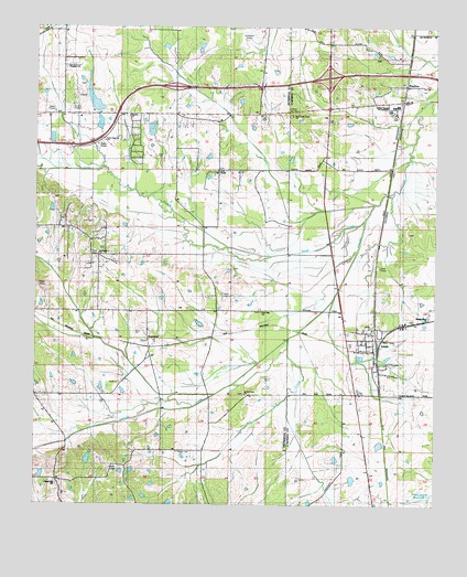
Artesia, MS USGS Topographic Map
Click on map above to begin viewing in our Map Viewer.

This topographic map contains these locations and features:
Feature Name Type Latitude Longitude GNIS ID View Map
ArtesiaPopulated PlaceN33.4154°W88.6439°666384View Map
Artesia Post OfficePost OfficeN33.4154°W88.6436°2768616View Map
Austin Church of Christ HolinessChurchN33.4068°W88.7234°682882View Map
Austin SchoolSchoolN33.4068°W88.7242°666431View Map
Belaire ChurchChurchN33.4768°W88.7214°682885View Map
Belaire EstatesPopulated PlaceN33.4737°W88.7201°682886View Map
Beulah Grove ChurchChurchN33.4240°W88.6273°667054View Map
Black JackPopulated PlaceN33.4376°W88.7320°682891View Map
Blackjack Missionary Baptist ChurchChurchN33.4404°W88.7306°682892View Map
Blackjack SchoolSchoolN33.4398°W88.7289°667246View Map
Bush CrossingLocaleN33.4043°W88.6417°687751View Map
Chapel Hill Baptist ChurchChurchN33.3804°W88.7431°682900View Map
Chapel Hill SchoolSchoolN33.3804°W88.7434°668336View Map
Chittobochiah CreekStreamN33.4535°W88.6445°710087View Map
Crain Lake DamDamN33.3868°W88.7034°682042View Map
Curtis ChapelChurchN33.4626°W88.6934°669031View Map
Curtis Chapel CemeteryCemeteryN33.4626°W88.6934°705753View Map
Davis Lake DamDamN33.4701°W88.7134°682113View Map
East Oktibbeha Volunteer Fire DepartmentBuildingN33.4768°W88.7193°2665854View Map
East Oktibbeha Volunteer Fire Department Sessums StationBuildingN33.4259°W88.7202°2665853View Map
East Sand Creek ChurchChurchN33.4768°W88.6698°677337View Map
East Starkville ChurchChurchN33.4704°W88.7289°682921View Map
Fox CemeteryCemeteryN33.4490°W88.7325°670145View Map
Golden Triangle Vocational Technical SchoolSchoolN33.4796°W88.6375°690838View Map
Gordon Lake DamDamN33.3835°W88.7201°682035View Map
Hickory Grove (historical)LocaleN33.4773°W88.7070°682945View Map
Hickory Grove EstatesPopulated PlaceN33.4626°W88.7000°682946View Map
Johnson Lake DamDamN33.4718°W88.7301°682117View Map
Jones Lake DamDamN33.4218°W88.7184°682069View Map
Kingdom HallChurchN33.4893°W88.7412°682953View Map
Lowndes County District 5 Volunteer Fire and Rescue Department Artesia StationBuildingN33.4143°W88.6441°2665635View Map
Lumis ChurchChurchN33.4476°W88.6934°672956View Map
Massey Lake DamDamN33.3901°W88.6934°682049View Map
MayhewPopulated PlaceN33.4848°W88.6345°673265View Map
Mayhew CemeteryCemeteryN33.4762°W88.6370°673266View Map
Mississippi No Name 116 DamDamN33.4001°W88.6684°692364View Map
Norris Lake DamDamN33.4785°W88.7301°682126View Map
Parish Lake DamDamN33.3768°W88.7100°682027View Map
Parrish CemeteryCemeteryN33.3843°W88.7242°675476View Map
Peters CemeteryCemeteryN33.3887°W88.7053°675648View Map
Red Acre (historical)LocaleN33.4251°W88.7153°705768View Map
Red Bud CreekStreamN33.4187°W88.6709°676519View Map
Rice CemeteryCemeteryN33.4404°W88.7306°676621View Map
Saint Matthews ChurchChurchN33.4040°W88.6848°683006View Map
Saint Matthews SchoolSchoolN33.4046°W88.6848°677171View Map
Sand CreekStreamN33.4504°W88.6467°677332View Map
Sand Creek CemeteryCemeteryN33.4773°W88.6700°710100View Map
Seitz CemeteryCemeteryN33.4298°W88.6917°677502View Map
SessumsPopulated PlaceN33.4162°W88.7142°677521View Map
Sessums CemeteryCemeteryN33.4182°W88.7150°705773View Map
Sessums Methodist ChurchChurchN33.4182°W88.7151°705774View Map
Supervisor District 2CivilN33.4742°W88.7305°712013View Map
Town of ArtesiaCivilN33.4163°W88.6424°2405171View Map
True Vine ChurchChurchN33.4257°W88.6789°683026View Map
Truevine SchoolSchoolN33.4251°W88.6787°678906View Map
White Lake DamDamN33.4035°W88.7367°682056View Map
WKOR-AM (Starkville)TowerN33.4790°W88.7445°680136View Map
Wolfe Creek (historical)Populated PlaceN33.4918°W88.6584°687951View Map

Note: Coordinates in the location and feature list above are referenced to NAD83 datum.


Copyright (C) 2008-2025 Ryan Niemi / Sunset Dynamics ... All Rights Reserved