TopoQuest Logo
Do you find TopoQuest useful?
Help keep TopoQuest running and adding new maps/features by donating!
Bitcoin:  19c7KJd3qBynnjoSw5npx9KScwjBe4ifkT
Litecoin:  LXs6TkuXGGXo1vDsWCkWVdjQX94eUKd6ui
Home View Maps Find Maps Find Places Resources & Links


Two Harbors, Minnesota Topographic Map

USGS Map Title: Two Harbors, MN
USGS Map MRC: 47091A6
DRG (GeoTIFF) Download: o47091a6.tif


Neighboring USGS Topographic Map Quads:


  King Lake, MN  
47091B7
 

  Highland, MN  
47091B6
 

  Two Harbors NE, MN  
47091B5
 

  McCarthy Creek, MN  
47091A7
 

  Two Harbors, MN  
47091A6
 

  Castle Danger, MN  
47091A5
 

  Knife River, MN  
46091H7


Map MRC Location:

N48°
W92°
N48°
W91°
H8 H7 H6 H5 H4 H3 H2 H1
G8 G7 G6 G5 G4 G3 G2 G1
F8 F7 F6 F5 F4 F3 F2 F1
E8 E7 E6 E5 E4 E3 E2 E1
D8 D7 D6 D5 D4 D3 D2 D1
C8 C7 C6 C5 C4 C3 C2 C1
B8 B7 B6 B5 B4 B3 B2 B1
A8 A7 A6 A5 A4 A3 A2 A1
N47°
W92°
N47°
W91°

Two Harbors, MN USGS 1:24K Topographic Map Preview:
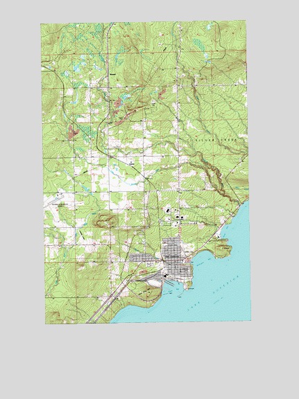
Two Harbors, MN USGS Topographic Map
Click on map above to begin viewing in our Map Viewer.

This topographic map contains these locations and features:
Feature Name Type Latitude Longitude GNIS ID View Map
3 Spot Historical MarkerParkN47.0178°W91.6722°2093503View Map
3M MuseumBuildingN47.0228°W91.6706°2093386View Map
Agate BayBayN47.0141°W91.6727°655084View Map
Anthony Private AirportAirportN47.0347°W91.7262°660447View Map
Barrass CottageHospitalN47.0189°W91.6669°2093407View Map
Burlington BayBayN47.0252°W91.6543°655566View Map
Burlington Bay CampgroundLocaleN47.0272°W91.6594°2093489View Map
Burlington Post Office (historical)Post OfficeN47.0303°W91.6583°2093358View Map
City of Two HarborsCivilN47.0301°W91.6752°2397074View Map
Community Health CenterHospitalN47.0294°W91.6667°2093483View Map
East Breakwater LightLocaleN47.0105°W91.6691°655041View Map
Edna G Tugboat MuseumBuildingN47.0167°W91.6722°2093395View Map
Evangelical Free ChurchChurchN47.0139°W91.7014°2093389View Map
Flood BayBayN47.0377°W91.6391°656272View Map
Holy Spirit Catholic CemeteryCemeteryN47.0217°W91.6653°2093361View Map
Holy Spirit Catholic ChurchChurchN47.0222°W91.6644°2093385View Map
John A Johnson SchoolSchoolN47.0292°W91.6694°2093399View Map
Johnson SchoolSchoolN47.0288°W91.6699°656812View Map
Lake County ArenaBuildingN47.0264°W91.6667°2093405View Map
Lake County CourthouseBuildingN47.0222°W91.6714°2093403View Map
Lake County Fair GroundsLocaleN47.0417°W91.6561°2093485View Map
Lake County Fairgrounds - CampingLocaleN47.0417°W91.6561°2093486View Map
Lake County JailBuildingN47.0222°W91.6718°2758651View Map
Lake County Sheriff's OfficeBuildingN47.0222°W91.6717°2758576View Map
Lake Superior Agate Geological MarkerParkN47.0444°W91.6353°2093504View Map
Lake View CottagesHospitalN47.0314°W91.6750°2093478View Map
Lake View HomeHospitalN47.0300°W91.6667°2093480View Map
Lake View HospitalHospitalN47.0301°W91.6662°2093482View Map
Lakeview CemeteryCemeteryN47.0243°W91.6858°2093491View Map
Lakeview National Golf CourseLocaleN47.0306°W91.6625°2093484View Map
Lakeview ParkParkN47.0216°W91.6621°656941View Map
Law Enforcement CenterBuildingN47.0222°W91.6717°2093404View Map
Lighthouse Point MuseumBuildingN47.0142°W91.6639°2093488View Map
Little Knife RiverStreamN47.0297°W91.7366°657077View Map
Little Stewart RiverStreamN47.0547°W91.6402°657133View Map
Minnehaha SchoolSchoolN47.0233°W91.6728°2093396View Map
Municipal Water and Light PlantLocaleN47.0185°W91.6599°655039View Map
Northwoods Christian AcademySchoolN47.0242°W91.6725°2093398View Map
Odegard ParkParkN47.0322°W91.6764°2093393View Map
Paul Van Hoven ParkParkN47.0175°W91.6725°2093492View Map
Penmaraliter CampgroundLocaleN47.0197°W91.6958°2093390View Map
Pork City HillSummitN47.0124°W91.6874°657906View Map
Richard B Helgeson AirportAirportN47.0526°W91.7430°660446View Map
Richard Lammi SCS DamDamN47.0550°W91.7200°1777180View Map
Segog ParkParkN47.0283°W91.6956°2093490View Map
Skunk CreekStreamN47.0244°W91.6613°658297View Map
StewartPopulated PlaceN47.1033°W91.7093°658477View Map
Stewart RiverStreamN47.0474°W91.6305°658479View Map
Sunrise Nursing HomeHospitalN47.0314°W91.6675°2093481View Map
Thomas Owens ParkParkN47.0214°W91.6703°2093394View Map
Two HarborsPopulated PlaceN47.0227°W91.6707°658799View Map
Two Harbors City HallBuildingN47.0194°W91.6703°2093402View Map
Two Harbors Dock DamDamN47.0116°W91.6802°1777043View Map
Two Harbors High SchoolSchoolN47.0231°W91.6667°2093397View Map
Two Harbors Jehovah's WitnessesChurchN47.0208°W91.7100°2093391View Map
Two Harbors LibraryBuildingN47.0225°W91.6703°2093401View Map
Two Harbors LightLocaleN47.0138°W91.6638°655038View Map
Two Harbors LighthouseLocaleN47.0142°W91.6639°2093487View Map
Two Harbors Police DepartmentBuildingN47.0220°W91.6717°2758540View Map
Two Harbors Post OfficePost OfficeN47.0200°W91.6706°2093400View Map
Two Harbors Railroad StationLocaleN47.0222°W91.6778°2093387View Map
Two Harbors Volunteer Fire DepartmentBuildingN47.0398°W91.6681°2666409View Map
Voyageur Trailer ParkPopulated PlaceN47.0228°W91.6706°2093388View Map
WaldoPopulated PlaceN47.0660°W91.6991°658880View Map
West Breakwater LightLocaleN47.0119°W91.6746°655040View Map

Note: Coordinates in the location and feature list above are referenced to NAD83 datum.


Copyright (C) 2008-2025 Ryan Niemi / Sunset Dynamics ... All Rights Reserved