TopoQuest Logo
Do you find TopoQuest useful?
Help keep TopoQuest running and adding new maps/features by donating!
Bitcoin:  19c7KJd3qBynnjoSw5npx9KScwjBe4ifkT
Litecoin:  LXs6TkuXGGXo1vDsWCkWVdjQX94eUKd6ui
Home View Maps Find Maps Find Places Resources & Links


Tyler, Minnesota Topographic Map

USGS Map Title: Tyler, MN
USGS Map MRC: 44096C2
DRG (GeoTIFF) Download: o44096c2.tif


Neighboring USGS Topographic Map Quads:


  Lake Benton NE, MN  
44096D3
 

  Arco, MN  
44096D2
 

  Gislason Lake, MN  
44096D1
 

  Lake Benton, MN  
44096C3
 

  Tyler, MN  
44096C2
 

  Dead Coon Lake, MN  
44096C1
 

  Verdi, MN  
44096B3
 

  Ruthton NW, MN  
44096B2
 

  Ruthton, MN  
44096B1


Map MRC Location:

N45°
W97°
N45°
W96°
H8 H7 H6 H5 H4 H3 H2 H1
G8 G7 G6 G5 G4 G3 G2 G1
F8 F7 F6 F5 F4 F3 F2 F1
E8 E7 E6 E5 E4 E3 E2 E1
D8 D7 D6 D5 D4 D3 D2 D1
C8 C7 C6 C5 C4 C3 C2 C1
B8 B7 B6 B5 B4 B3 B2 B1
A8 A7 A6 A5 A4 A3 A2 A1
N44°
W97°
N44°
W96°

Tyler, MN USGS 1:24K Topographic Map Preview:
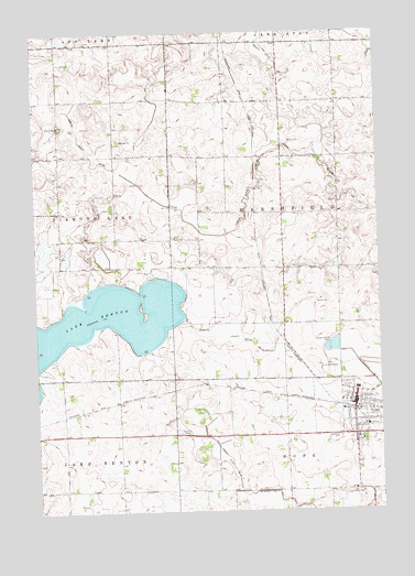
Tyler, MN USGS Topographic Map
Click on map above to begin viewing in our Map Viewer.

This topographic map contains these locations and features:
Feature Name Type Latitude Longitude GNIS ID View Map
Alliance ChurchChurchN44.2783°W96.1311°2051717View Map
Avera Tyler HospitalHospitalN44.2721°W96.1302°2051719View Map
Chen-Bay State Wildlife Management AreaParkN44.3177°W96.2473°641139View Map
City of TylerCivilN44.2787°W96.1355°2397075View Map
County Ditch Number FifteenCanalN44.2936°W96.1714°641692View Map
County Ditch Number FortyCanalN44.2639°W96.1820°642066View Map
County Ditch Number FourCanalN44.3733°W96.1681°642059View Map
Danebod CemeteryCemeteryN44.2691°W96.1406°642618View Map
Danebod Lutheran ChurchChurchN44.2683°W96.1342°2051712View Map
First Baptist ChurchChurchN44.2780°W96.1320°2051714View Map
First English Lutheran ChurchChurchN44.2780°W96.1328°2051713View Map
Immanuel Lutheran ChurchChurchN44.2730°W96.1314°2051715View Map
Judicial Ditch Number ThirtyCanalN44.3350°W96.1689°645893View Map
Lake BentonLakeN44.2966°W96.2416°639942View Map
Lincoln County FairgroundsLocaleN44.2833°W96.1378°2051727View Map
Lincoln County Waterfowl Production AreaParkN44.3707°W96.2120°2765373View Map
Lions Club ParkParkN44.2736°W96.1392°2051729View Map
Saint Dionysius Catholic ChurchChurchN44.2786°W96.1317°2051716View Map
Sunrise Manor Nursing HomeHospitalN44.2725°W96.1267°2051718View Map
Township of MarshfieldCivilN44.3287°W96.1400°664921View Map
TylerLocaleN44.2761°W96.1348°2051725View Map
TylerPopulated PlaceN44.2783°W96.1348°658809View Map
Tyler Ambulance ServiceBuildingN44.2721°W96.1301°2721377View Map
Tyler City HallBuildingN44.2789°W96.1345°2051722View Map
Tyler City ParkParkN44.2775°W96.1359°2051723View Map
Tyler Community Golf ClubLocaleN44.2850°W96.1420°2051728View Map
Tyler Fire DepartmentBuildingN44.2761°W96.1347°2666710View Map
Tyler Medical ClinicHospitalN44.2722°W96.1303°2051720View Map
Tyler Municipal AirportAirportN44.2856°W96.1483°660449View Map
Tyler Police DepartmentBuildingN44.2788°W96.1343°2758657View Map
Tyler Post OfficePost OfficeN44.2797°W96.1350°2051721View Map
Tyler Public LlibraryBuildingN44.2789°W96.1345°2051724View Map
Tyler Public SchoolsSchoolN44.2819°W96.1342°2051726View Map

Note: Coordinates in the location and feature list above are referenced to NAD83 datum.


Copyright (C) 2008-2024 Ryan Niemi / Sunset Dynamics ... All Rights Reserved