TopoQuest Logo
Do you find TopoQuest useful?
Help keep TopoQuest running and adding new maps/features by donating!
Bitcoin:  19c7KJd3qBynnjoSw5npx9KScwjBe4ifkT
Litecoin:  LXs6TkuXGGXo1vDsWCkWVdjQX94eUKd6ui
Home View Maps Find Maps Find Places Resources & Links


Unaka, North Carolina Topographic Map

USGS Map Title: Unaka, NC
USGS Map MRC: 35084B2
DRG (GeoTIFF) Download: o35084b2.tif


Neighboring USGS Topographic Map Quads:


  Tellico Plains, TN  
35084C3
 

  Bald River Falls, TN  
35084C2
 

  Big Junction, TN  
35084C1
 

  Farner, TN  
35084B3
 

  Unaka, NC  
35084B2
 

  McDaniel Bald, NC  
35084B1
 

  Isabella, TN  
35084A3
 

  Persimmon Creek, NC  
35084A2
 

  Murphy, NC  
35084A1


Map MRC Location:

N36°
W85°
N36°
W84°
H8 H7 H6 H5 H4 H3 H2 H1
G8 G7 G6 G5 G4 G3 G2 G1
F8 F7 F6 F5 F4 F3 F2 F1
E8 E7 E6 E5 E4 E3 E2 E1
D8 D7 D6 D5 D4 D3 D2 D1
C8 C7 C6 C5 C4 C3 C2 C1
B8 B7 B6 B5 B4 B3 B2 B1
A8 A7 A6 A5 A4 A3 A2 A1
N35°
W85°
N35°
W84°

Unaka, NC USGS 1:24K Topographic Map Preview:
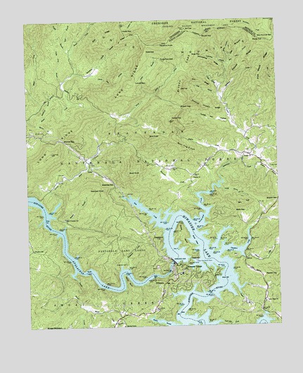
Unaka, NC USGS Topographic Map
Click on map above to begin viewing in our Map Viewer.

This topographic map contains these locations and features:
Feature Name Type Latitude Longitude GNIS ID View Map
Anderson CreekStreamN35.1490°W84.2035°980176View Map
Apalachia LakeReservoirN35.1650°W84.2366°1008755View Map
Bear BranchStreamN35.2387°W84.2263°1008987View Map
Bear Hug CreekStreamN35.1909°W84.1835°1004629View Map
Bear Hug RidgeRidgeN35.1987°W84.1699°980724View Map
Bear Paw Resort DockLocaleN35.1520°W84.1655°980728View Map
Beaverdam CreekStreamN35.1667°W84.1666°1009084View Map
Beavers BranchStreamN35.1651°W84.2319°980872View Map
Bethel ChurchChurchN35.1862°W84.1671°981121View Map
Betts GapGapN35.1723°W84.1460°981249View Map
Bill TopSummitN35.1754°W84.1427°1019171View Map
Bird KnobSummitN35.2029°W84.1899°1019186View Map
Bryson BranchStreamN35.1912°W84.1335°1009713View Map
Bryson CreekStreamN35.1912°W84.1502°982085View Map
Bryson GapGapN35.1765°W84.1257°982086View Map
Bryson GapGapN35.2148°W84.1724°982087View Map
Bryson LeadRidgeN35.2295°W84.1705°982088View Map
Buck KnobSummitN35.1884°W84.1991°1019361View Map
Buckberry BranchStreamN35.2115°W84.2416°982122View Map
Buckhorn CreekStreamN35.2176°W84.1521°982141View Map
Chambers CreekStreamN35.1537°W84.1555°1010160View Map
Chestnut Orchard RidgeRidgeN35.2154°W84.1616°983121View Map
Cindy BranchStreamN35.2226°W84.1538°983194View Map
Copper CreekStreamN35.1951°W84.1352°983525View Map
Copper RidgeRidgeN35.2342°W84.1385°983530View Map
Deaden TopSummitN35.1456°W84.1266°1019929View Map
Eagle GapGapN35.1526°W84.1682°984467View Map
Elbow CreekStreamN35.2104°W84.2488°984677View Map
Farrow CemeteryCemeteryN35.1459°W84.1546°985013View Map
Floyde BranchStreamN35.2367°W84.2271°1011297View Map
Fowler BendBendN35.1620°W84.1730°985347View Map
Garrett CemeteryCemeteryN35.1917°W84.1807°985580View Map
Gowans CoveValleyN35.2288°W84.2238°985877View Map
Groundhog BranchStreamN35.2309°W84.1488°986170View Map
Groundhog RidgeRidgeN35.2334°W84.1585°986172View Map
Hamby BendBendN35.1437°W84.2002°986331View Map
Hazelnut KnobSummitN35.2406°W84.1824°1020663View Map
Hipps GapGapN35.2459°W84.2008°986853View Map
Hipps RidgeRidgeN35.2415°W84.2013°986854View Map
Hiwassee DamDamN35.1514°W84.1777°986856View Map
Hiwassee LakeReservoirN35.1529°W84.1780°1012084View Map
Hiwassee VillagePopulated PlaceN35.1490°W84.1713°1020784View Map
Hyatt Mill CreekStreamN35.1256°W84.1591°987301View Map
Joe CoveValleyN35.2197°W84.1540°987621View Map
Joe TopSummitN35.2217°W84.1727°1020960View Map
Johnson CreekStreamN35.1548°W84.1435°1012533View Map
Kilby BranchStreamN35.2317°W84.1491°987952View Map
Lenderman CemeteryCemeteryN35.1515°W84.2010°988349View Map
Locust GapGapN35.2165°W84.1938°988840View Map
Locust Gap BranchStreamN35.2284°W84.2177°988842View Map
Long RidgeRidgeN35.1965°W84.2369°1013171View Map
Micken BranchStreamN35.1251°W84.1680°1013485View Map
Miller BranchStreamN35.2342°W84.1482°989993View Map
Moccasin CreekStreamN35.1790°W84.1666°990114View Map
Morrow BranchStreamN35.2079°W84.2435°990274View Map
Morrow CemeteryCemeteryN35.2048°W84.2413°990275View Map
Morrow GapGapN35.2015°W84.2316°990277View Map
Moss GapGapN35.2367°W84.1896°990289View Map
New Hope ChurchChurchN35.1342°W84.1319°990999View Map
New Prospect CemeteryCemeteryN35.1695°W84.2316°1018231View Map
New Prospect ChurchChurchN35.1698°W84.2313°991078View Map
Nim RidgeRidgeN35.2248°W84.1621°991153View Map
Nit TopSummitN35.2465°W84.1699°991156View Map
North Shoal CreekStreamN35.1717°W84.2388°991272View Map
OgreetaPopulated PlaceN35.1534°W84.1413°1021724View Map
Patterson TopSummitN35.1598°W84.1844°1021830View Map
Pine Stand RidgeRidgeN35.2220°W84.1294°1014444View Map
Pleasant HillPopulated PlaceN35.1570°W84.2469°1022007View Map
Pleasant Hill ChurchChurchN35.1565°W84.2483°1018236View Map
Pot Log BranchStreamN35.2309°W84.1491°992740View Map
Potter BranchStreamN35.2190°W84.1885°992747View Map
Powell BranchStreamN35.1817°W84.1530°992767View Map
Pretty Pine BranchStreamN35.2251°W84.2313°992797View Map
Quinn CreekStreamN35.1334°W84.2205°1014691View Map
Reids ChapelChurchN35.1254°W84.2021°993236View Map
Rocky TopSummitN35.2417°W84.1299°1022376View Map
Rose CemeteryCemeteryN35.1790°W84.2002°993688View Map
Rose CreekStreamN35.1659°W84.1807°993694View Map
Rose TopSummitN35.2351°W84.1666°1022394View Map
Round TopSummitN35.2437°W84.1616°1022424View Map
Sled Runner GapGapN35.2429°W84.1257°994909View Map
South Shoal CreekStreamN35.1484°W84.2266°1015712View Map
Swansee GapGapN35.1837°W84.2066°995768View Map
Swansee KnobSummitN35.1809°W84.2110°1022866View Map
Taylor BranchStreamN35.1426°W84.1471°995879View Map
Three Fork GapGapN35.2337°W84.1827°996076View Map
Township of BeaverdamCivilN35.2040°W84.1621°1026544View Map
Turkey Pen HollowValleyN35.2077°W84.1474°996341View Map
Turner TopSummitN35.2101°W84.1771°1023015View Map
UnakaPopulated PlaceN35.1954°W84.1416°1023032View Map
Unaka CemeteryCemeteryN35.1904°W84.1282°996408View Map
Unaka Elementary SchoolSchoolN35.1940°W84.1385°1006509View Map
Unaka Volunteer Fire DepartmentBuildingN35.1937°W84.1380°2638971View Map
VioletPopulated PlaceN35.1898°W84.2177°1023085View Map
Wolf RidgeRidgeN35.2442°W84.2113°997541View Map

Note: Coordinates in the location and feature list above are referenced to NAD83 datum.


Copyright (C) 2008-2025 Ryan Niemi / Sunset Dynamics ... All Rights Reserved