TopoQuest Logo
Do you find TopoQuest useful?
Help keep TopoQuest running and adding new maps/features by donating!
Bitcoin:  19c7KJd3qBynnjoSw5npx9KScwjBe4ifkT
Litecoin:  LXs6TkuXGGXo1vDsWCkWVdjQX94eUKd6ui
Home View Maps Find Maps Find Places Resources & Links


Uncompahgre Butte, Colorado Topographic Map

USGS Map Title: Uncompahgre Butte, CO
USGS Map MRC: 38108E6
DRG (GeoTIFF) Download: o38108e6.tif


Neighboring USGS Topographic Map Quads:


  Pine Mountain, CO  
38108F7
 

  Casto Reservoir, CO  
38108F6
 

  Keith Creek, CO  
38108F5
 

  Calamity Mesa, CO  
38108E7
 

  Uncompahgre Butte, CO  
38108E6
 

  Snipe Mountain, CO  
38108E5
 

  Red Canyon, CO  
38108D7
 

  Atkinson Creek, CO  
38108D6
 

  Windy Point, CO  
38108D5


Map MRC Location:

N39°
W109°
N39°
W108°
H8 H7 H6 H5 H4 H3 H2 H1
G8 G7 G6 G5 G4 G3 G2 G1
F8 F7 F6 F5 F4 F3 F2 F1
E8 E7 E6 E5 E4 E3 E2 E1
D8 D7 D6 D5 D4 D3 D2 D1
C8 C7 C6 C5 C4 C3 C2 C1
B8 B7 B6 B5 B4 B3 B2 B1
A8 A7 A6 A5 A4 A3 A2 A1
N38°
W109°
N38°
W108°

Uncompahgre Butte, CO USGS 1:24K Topographic Map Preview:
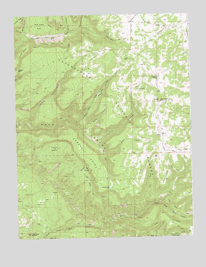
Uncompahgre Butte, CO USGS Topographic Map
Click on map above to begin viewing in our Map Viewer.

This topographic map contains these locations and features:
Feature Name Type Latitude Longitude GNIS ID View Map
Barklay CreekStreamN38.6183°W108.6290°185588View Map
Beaver Dam Branch North Fork Mesa CreekStreamN38.5650°W108.7073°185589View Map
Beaver Dam TrailTrailN38.5833°W108.6873°185596View Map
Blue Creek ParkFlatN38.6194°W108.7318°185593View Map
Blue Creek TrailTrailN38.6180°W108.7007°185594View Map
Bunch Ground Branch Blue CreekStreamN38.6180°W108.7037°185436View Map
California SpringSpringN38.5891°W108.6485°185587View Map
Campbell LakeLakeN38.5281°W108.6839°185580View Map
Campbell PointSummitN38.5244°W108.6645°185575View Map
Coal CreekStreamN38.5180°W108.6559°185581View Map
Colcord CampLocaleN38.5453°W108.6518°185582View Map
Coyote BasinBasinN38.5505°W108.7234°185597View Map
Deep CanyonValleyN38.5645°W108.7455°185574View Map
Franks BenchBenchN38.6047°W108.7440°185592View Map
Franks Bench TrailTrailN38.6094°W108.7207°185595View Map
Garvey BranchStreamN38.5611°W108.7020°185590View Map
Johnson BasinBasinN38.5005°W108.6382°203119View Map
Little Round MountainSummitN38.5025°W108.7412°185576View Map
Long CanyonValleyN38.5644°W108.7454°185591View Map
Lower Bench TrailTrailN38.5211°W108.6601°203121View Map
Mailbox Branch Blue CreekStreamN38.6161°W108.7115°185437View Map
Mailbox TrailTrailN38.6172°W108.7159°203120View Map
Massey BranchStreamN38.6125°W108.7418°185434View Map
The TongueRidgeN38.5097°W108.6462°203150View Map
Triangle MesaSummitN38.5950°W108.7482°203118View Map
Truck Stop PlacerMineN38.5067°W108.7357°1735824View Map
U C CreekStreamN38.5544°W108.6948°185585View Map
Uncompahgre ButteSummitN38.5767°W108.6476°185583View Map
Upper Bench TrailTrailN38.5417°W108.6309°203122View Map
Willow CreekStreamN38.5475°W108.6884°185584View Map

Note: Coordinates in the location and feature list above are referenced to NAD83 datum.


Copyright (C) 2008-2025 Ryan Niemi / Sunset Dynamics ... All Rights Reserved