TopoQuest Logo
Do you find TopoQuest useful?
Help keep TopoQuest running and adding new maps/features by donating!
Bitcoin:  19c7KJd3qBynnjoSw5npx9KScwjBe4ifkT
Litecoin:  LXs6TkuXGGXo1vDsWCkWVdjQX94eUKd6ui
Home View Maps Find Maps Find Places Resources & Links


Calamity Mesa, Colorado Topographic Map

USGS Map Title: Calamity Mesa, CO
USGS Map MRC: 38108E7
DRG (GeoTIFF) Download: o38108e7.tif


Neighboring USGS Topographic Map Quads:


  Gateway, CO  
38108F8
 

  Pine Mountain, CO  
38108F7
 

  Casto Reservoir, CO  
38108F6
 

  Juanita Arch, CO  
38108E8
 

  Calamity Mesa, CO  
38108E7
 

  Uncompahgre Butte, CO  
38108E6
 

  Roc Creek, CO  
38108D8
 

  Red Canyon, CO  
38108D7
 

  Atkinson Creek, CO  
38108D6


Map MRC Location:

N39°
W109°
N39°
W108°
H8 H7 H6 H5 H4 H3 H2 H1
G8 G7 G6 G5 G4 G3 G2 G1
F8 F7 F6 F5 F4 F3 F2 F1
E8 E7 E6 E5 E4 E3 E2 E1
D8 D7 D6 D5 D4 D3 D2 D1
C8 C7 C6 C5 C4 C3 C2 C1
B8 B7 B6 B5 B4 B3 B2 B1
A8 A7 A6 A5 A4 A3 A2 A1
N38°
W109°
N38°
W108°

Calamity Mesa, CO USGS 1:24K Topographic Map Preview:
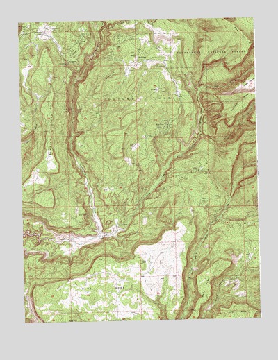
Calamity Mesa, CO USGS Topographic Map
Click on map above to begin viewing in our Map Viewer.

This topographic map contains these locations and features:
Feature Name Type Latitude Longitude GNIS ID View Map
Arrowhead CampLocaleN38.6200°W108.8626°185564View Map
Arrowhead MineMineN38.6130°W108.8598°1735984View Map
Arrowhead MinesMineN38.6222°W108.8573°185567View Map
Blue Creek CanyonValleyN38.5345°W108.8339°185556View Map
Blue Creek MinesMineN38.5805°W108.7979°185558View Map
Calamity CampLocaleN38.6078°W108.8490°185562View Map
Calamity CreekStreamN38.5350°W108.8345°185422View Map
Calamity MesaSummitN38.5950°W108.8576°203114View Map
Calamity MineMineN38.6064°W108.8448°1735979View Map
Calamity MinesMineN38.6150°W108.8429°185563View Map
Cliffdweller MinesMineN38.5889°W108.8493°185560View Map
Climax CampLocaleN38.6097°W108.8129°185569View Map
Dark CanyonValleyN38.5772°W108.7801°185559View Map
Elizabeth MinesMineN38.5494°W108.7790°185555View Map
G-2 ShaftMineN38.5958°W108.8029°185571View Map
Hidden Treasure MineMineN38.6228°W108.8707°185566View Map
Indian CreekStreamN38.6228°W108.8207°185456View Map
Long MesaSummitN38.5022°W108.7512°203117View Map
Moon MesaSummitN38.5230°W108.7673°203116View Map
New Verde MinesMineN38.6069°W108.8504°185561View Map
Outlaw MesaSummitN38.6164°W108.7893°185572View Map
Outlaw MinesMineN38.6150°W108.8207°185568View Map
Outlaw Twenty-three MineMineN38.6133°W108.8212°1735978View Map
Peach MinesMineN38.5722°W108.8159°185573View Map
Pine HillSummitN38.6144°W108.7518°203077View Map
Potato MountainSummitN38.6050°W108.8223°185570View Map
Powder Horn Incline MineMineN38.5978°W108.8579°1735986View Map
Raven MineMineN38.5567°W108.7868°1735692View Map
Ronnie MineMineN38.6078°W108.8143°1735694View Map
Salute MineMineN38.5692°W108.8232°1735695View Map
Scott MineMineN38.5697°W108.8598°1735696View Map
Small Spot MineMineN38.6200°W108.8701°185565View Map
Snowshoe MineMineN38.6133°W108.8220°1735699View Map
Spring MineMineN38.6133°W108.8220°1735700View Map
Stormy Treasure MineMineN38.5439°W108.8407°185557View Map
Supply Eleven MineMineN38.5558°W108.8332°1735701View Map
Teepee Pole MineMineN38.5572°W108.8223°1735357View Map
Trojan MineMineN38.5889°W108.8329°1735703View Map
Yellowbird MinesMineN38.5625°W108.7807°185552View Map

Note: Coordinates in the location and feature list above are referenced to NAD83 datum.


Copyright (C) 2008-2024 Ryan Niemi / Sunset Dynamics ... All Rights Reserved