TopoQuest Logo
Do you find TopoQuest useful?
Help keep TopoQuest running and adding new maps/features by donating!
Bitcoin:  19c7KJd3qBynnjoSw5npx9KScwjBe4ifkT
Litecoin:  LXs6TkuXGGXo1vDsWCkWVdjQX94eUKd6ui
Home View Maps Find Maps Find Places Resources & Links


Varney, Kentucky Topographic Map

USGS Map Title: Varney, KY
USGS Map MRC: 37082F4
DRG (GeoTIFF) Download: o37082f4.tif


Neighboring USGS Topographic Map Quads:


  Inez, KY  
37082G5
 

  Kermit, WV  
37082G4
 

  Naugatuck, WV  
37082G3
 

  Thomas, KY  
37082F5
 

  Varney, KY  
37082F4
 

  Williamson, WV  
37082F3
 

  Broad Bottom, KY  
37082E5
 

  Meta, KY  
37082E4
 

  Belfry, KY  
37082E3


Map MRC Location:

N38°
W83°
N38°
W82°
H8 H7 H6 H5 H4 H3 H2 H1
G8 G7 G6 G5 G4 G3 G2 G1
F8 F7 F6 F5 F4 F3 F2 F1
E8 E7 E6 E5 E4 E3 E2 E1
D8 D7 D6 D5 D4 D3 D2 D1
C8 C7 C6 C5 C4 C3 C2 C1
B8 B7 B6 B5 B4 B3 B2 B1
A8 A7 A6 A5 A4 A3 A2 A1
N37°
W83°
N37°
W82°

Varney, KY USGS 1:24K Topographic Map Preview:
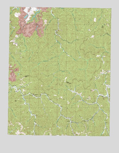
Varney, KY USGS Topographic Map
Click on map above to begin viewing in our Map Viewer.

This topographic map contains these locations and features:
Feature Name Type Latitude Longitude GNIS ID View Map
Apple Orchard BottomFlatN37.6716°W82.4915°2337485View Map
Apple Orchard CemeteryCemeteryN37.6726°W82.4955°2337486View Map
Apple Orchard Church of Regular BaptistChurchN37.6726°W82.4949°486011View Map
Bevins BranchStreamN37.6629°W82.3771°487063View Map
Big BranchStreamN37.6709°W82.4904°487116View Map
Big BranchStreamN37.7212°W82.4838°487121View Map
Big Lick BranchStreamN37.6354°W82.4663°487210View Map
Brushy Creek MissionChurchN37.6651°W82.4674°509914View Map
Brushy Hollow ForkStreamN37.6429°W82.3957°488145View Map
Brushy SchoolSchoolN37.6640°W82.4693°509915View Map
Caney CemeteryCemeteryN37.7240°W82.4424°488823View Map
Caney ForkStreamN37.7237°W82.4410°488856View Map
Carcass BranchStreamN37.7493°W82.4924°488920View Map
Conder Post Office (historical)Post OfficeN37.6745°W82.3772°2120571View Map
Crooked ForkStreamN37.6332°W82.3799°490387View Map
Davis ForkStreamN37.6890°W82.4374°490665View Map
Double Blind LickStreamN37.6662°W82.4157°491039View Map
Dunkard Church (historical)ChurchN37.6618°W82.3907°510085View Map
Elkins ForkStreamN37.6654°W82.3779°494997View Map
Elkins Fork (historical)Populated PlaceN37.6545°W82.3882°2337544View Map
Elkins Fork School (historical)SchoolN37.6560°W82.3889°2337545View Map
Flag KnobSummitN37.6584°W82.4918°492160View Map
Flat HollowValleyN37.7190°W82.4161°2337387View Map
Forks of Brushy School (historical)SchoolN37.6673°W82.4846°510089View Map
Fraley BranchStreamN37.6745°W82.3779°492423View Map
Francis CemeteryCemeteryN37.6337°W82.3813°492437View Map
Gin ForkStreamN37.6629°W82.4604°492861View Map
Gourdneck BranchStreamN37.6904°W82.4060°493057View Map
Grassy Branch (historical)StreamN37.7312°W82.4654°493145View Map
Halfway BranchStreamN37.6854°W82.3799°493561View Map
Harmon Manor School (historical)SchoolN37.6448°W82.4671°2120808View Map
Head of Caney Fork School (historical)SchoolN37.7193°W82.4163°510098View Map
Head of Meathouse Creek School (historical)SchoolN37.7048°W82.4979°510101View Map
Head of Petercave Fork School (historical)SchoolN37.7168°W82.4815°510103View Map
HeenonPopulated PlaceN37.6668°W82.4899°508216View Map
Heenon ChurchChurchN37.6637°W82.4810°509910View Map
Heenon Post Office (historical)Post OfficeN37.6713°W82.4906°2120822View Map
Helsey Post Office (historical)Post OfficeN37.6650°W82.3860°2120825View Map
Hobbs ForkStreamN37.7073°W82.4327°494323View Map
Hurricane BranchStreamN37.6451°W82.4349°494815View Map
Hurricane on Brushy School (historical)SchoolN37.6451°W82.4340°510111View Map
Jarad Post Office (historical)Post OfficeN37.6639°W82.4818°2120853View Map
John Young BranchStreamN37.6382°W82.4229°495339View Map
Johnson Rockhouse ForkStreamN37.7020°W82.4382°495424View Map
Jude ForkStreamN37.6890°W82.4374°495541View Map
LauraPopulated PlaceN37.7259°W82.4429°510119View Map
Left Fork Bushy ForkStreamN37.6632°W82.4818°496202View Map
Left Fork Petercave Fork (historical)StreamN37.7409°W82.4688°496249View Map
Lick BranchStreamN37.7289°W82.4403°2337399View Map
Lick ForkStreamN37.7082°W82.4776°496500View Map
Licklog BranchStreamN37.6704°W82.4260°496528View Map
Little BranchStreamN37.6454°W82.4701°496640View Map
Lowgap ForkStreamN37.7065°W82.4999°497322View Map
Mary Elizabeth ChurchChurchN37.6884°W82.3765°497641View Map
Maynard ForkStreamN37.6845°W82.4449°497733View Map
Middle Fork Rockhouse ForkStreamN37.6523°W82.3865°498138View Map
Mount Zion ChurchChurchN37.6382°W82.3799°509912View Map
Mouth of Caney Fork School (historical)SchoolN37.7254°W82.4429°510136View Map
Mud LickStreamN37.6815°W82.4435°498996View Map
Pauley School (historical)SchoolN37.6287°W82.3763°510149View Map
Peachtree ForkStreamN37.7082°W82.3810°500327View Map
PisoPopulated PlaceN37.6359°W82.4674°508829View Map
Piso ChurchChurchN37.6440°W82.4660°509913View Map
Piso Post Office (historical)Post OfficeN37.6362°W82.4649°2336984View Map
Piso School (historical)SchoolN37.6395°W82.4679°510156View Map
Puncheoncamp BranchStreamN37.6682°W82.4188°501456View Map
Road ForkStreamN37.6709°W82.4371°502023View Map
RockhouseLocaleN37.6452°W82.3781°2337008View Map
Rockhouse BranchStreamN37.7404°W82.4443°502177View Map
Rockhouse ChurchChurchN37.6582°W82.3918°509911View Map
Rockhouse Creek School (historical)SchoolN37.7426°W82.4457°510160View Map
Rockhouse ForkStreamN37.6576°W82.3910°502203View Map
Rocklick BranchStreamN37.6993°W82.4040°510161View Map
Rocklick BranchStreamN37.6651°W82.4124°502214View Map
Runyon ForkStreamN37.7082°W82.4776°502472View Map
Rye Straw BranchStreamN37.6382°W82.4232°502542View Map
Sartin BranchStreamN37.7197°W82.4431°2337423View Map
Schoolhouse BranchStreamN37.7383°W82.4403°2337187View Map
Skinned Chestnut BranchStreamN37.6698°W82.4310°503609View Map
Smith CemeteryCemeteryN37.6420°W82.3993°503764View Map
Spankum BranchStreamN37.6707°W82.4951°504020View Map
Stonecoal BranchStreamN37.7020°W82.4124°504466View Map
Taylor BranchStreamN37.6659°W82.3874°504990View Map
Threeforks DivisionCivilN37.7384°W82.4246°1937290View Map
Threeforks School (historical)SchoolN37.7415°W82.4688°510176View Map
Trace BranchStreamN37.6595°W82.4082°505409View Map
Upper Turkey (historical)Populated PlaceN37.6503°W82.3962°2337087View Map
VarneyPopulated PlaceN37.6387°W82.4238°509276View Map
Varney CemeteryCemeteryN37.6395°W82.4218°505987View Map
Varney Post Office (historical)Post OfficeN37.6392°W82.4214°2337088View Map
Walnut ForkStreamN37.6401°W82.4018°506166View Map
Wildcat BranchStreamN37.7176°W82.4415°506726View Map
Williams CemeteryCemeteryN37.6265°W82.4165°506804View Map
Wolf Creek Church of the BrethrenChurchN37.7273°W82.4426°507004View Map

Note: Coordinates in the location and feature list above are referenced to NAD83 datum.


Copyright (C) 2008-2025 Ryan Niemi / Sunset Dynamics ... All Rights Reserved