TopoQuest Logo
Do you find TopoQuest useful?
Help keep TopoQuest running and adding new maps/features by donating!
Bitcoin:  19c7KJd3qBynnjoSw5npx9KScwjBe4ifkT
Litecoin:  LXs6TkuXGGXo1vDsWCkWVdjQX94eUKd6ui
Home View Maps Find Maps Find Places Resources & Links


Veblen, South Dakota Topographic Map

USGS Map Title: Veblen, SD
USGS Map MRC: 45097G3
DRG (GeoTIFF) Download: o45097g3.tif


Neighboring USGS Topographic Map Quads:


  Marlow, SD  
45097H4
 

  Veblen NE, ND  
45097H3
 

  Claire City NW, ND  
45097H2
 

  Hillhead, SD  
45097G4
 

  Veblen, SD  
45097G3
 

  Claire City SW, SD  
45097G2
 

  Lake City, SD  
45097F4
 

  South Red Iron Lake, SD  
45097F3
 

  Whitestone Lake, SD  
45097F2


Map MRC Location:

N46°
W98°
N46°
W97°
H8 H7 H6 H5 H4 H3 H2 H1
G8 G7 G6 G5 G4 G3 G2 G1
F8 F7 F6 F5 F4 F3 F2 F1
E8 E7 E6 E5 E4 E3 E2 E1
D8 D7 D6 D5 D4 D3 D2 D1
C8 C7 C6 C5 C4 C3 C2 C1
B8 B7 B6 B5 B4 B3 B2 B1
A8 A7 A6 A5 A4 A3 A2 A1
N45°
W98°
N45°
W97°

Veblen, SD USGS 1:24K Topographic Map Preview:
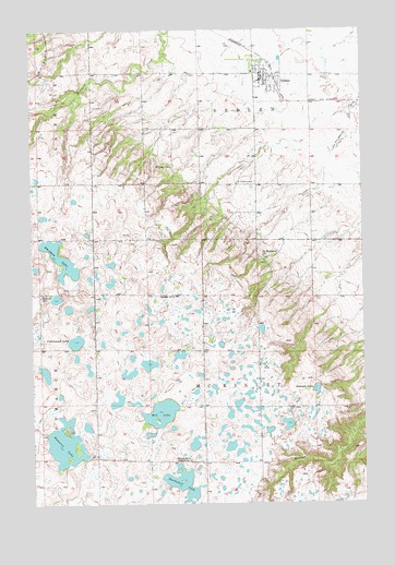
Veblen, SD USGS Topographic Map
Click on map above to begin viewing in our Map Viewer.

This topographic map contains these locations and features:
Feature Name Type Latitude Longitude GNIS ID View Map
Abraham LakeLakeN45.8148°W97.3644°1253584View Map
City of VeblenCivilN45.8620°W97.2869°1267611View Map
Cottonwood LakeLakeN45.7930°W97.3593°1254490View Map
Dumarce LakeLakeN45.7653°W97.3635°1254799View Map
Hill LakeLakeN45.7740°W97.3272°1255559View Map
Saint Luke ChurchChurchN45.8391°W97.3218°1257658View Map
Saint Luke's Episcopal CemeteryCemeteryN45.8390°W97.3228°2779214View Map
Saint Matthew CemeteryCemeteryN45.8348°W97.2910°1257689View Map
Saint Matthew ChurchChurchN45.8152°W97.2879°1257691View Map
Saint Matthew’s Church CemeteryCemeteryN45.8150°W97.2882°2779215View Map
School Number 1SchoolN45.7619°W97.3162°1257863View Map
School Number 2SchoolN45.8044°W97.3259°1257888View Map
Summit LakeLakeN45.7801°W97.2685°1258409View Map
Township of Dumarce (historical)CivilN45.7688°W97.3415°1267769View Map
Township of McKinleyCivilN45.7760°W97.2896°1267759View Map
Turtlefoot LakeLakeN45.7555°W97.3191°1258652View Map
VeblenPopulated PlaceN45.8630°W97.2876°1258738View Map
Veblen CemeteryCemeteryN45.8701°W97.2918°2779216View Map
Veblen City HallBuildingN45.8641°W97.2915°2725313View Map
Veblen Fire and RescueBuildingN45.8636°W97.2877°2580860View Map
Veblen Post OfficePost OfficeN45.8618°W97.2878°2712000View Map
Zion CemeteryCemeteryN45.8052°W97.3718°2779217View Map
Zion ChurchChurchN45.8052°W97.3715°1259120View Map

Note: Coordinates in the location and feature list above are referenced to NAD83 datum.


Copyright (C) 2008-2024 Ryan Niemi / Sunset Dynamics ... All Rights Reserved