TopoQuest Logo
Do you find TopoQuest useful?
Help keep TopoQuest running and adding new maps/features by donating!
Bitcoin:  19c7KJd3qBynnjoSw5npx9KScwjBe4ifkT
Litecoin:  LXs6TkuXGGXo1vDsWCkWVdjQX94eUKd6ui
Home View Maps Find Maps Find Places Resources & Links


Verdery, South Carolina Topographic Map

USGS Map Title: Verdery, SC
USGS Map MRC: 34082A3
DRG (GeoTIFF) Download: o34082a3.tif


Neighboring USGS Topographic Map Quads:


  Abbeville West, SC  
34082B4
 

  Abbeville East, SC  
34082B3
 

  Greenwood, SC  
34082B2
 

  Calhoun Creek, SC  
34082A4
 

  Verdery, SC  
34082A3
 

  Bradley, SC  
34082A2
 

  Willington, SC  
33082H4
 

  McCormick, SC  
33082H3
 

  Winterseat, SC  
33082H2


Map MRC Location:

N35°
W83°
N35°
W82°
H8 H7 H6 H5 H4 H3 H2 H1
G8 G7 G6 G5 G4 G3 G2 G1
F8 F7 F6 F5 F4 F3 F2 F1
E8 E7 E6 E5 E4 E3 E2 E1
D8 D7 D6 D5 D4 D3 D2 D1
C8 C7 C6 C5 C4 C3 C2 C1
B8 B7 B6 B5 B4 B3 B2 B1
A8 A7 A6 A5 A4 A3 A2 A1
N34°
W83°
N34°
W82°

Verdery, SC USGS 1:24K Topographic Map Preview:
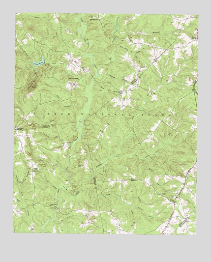
Verdery, SC USGS Topographic Map
Click on map above to begin viewing in our Map Viewer.

This topographic map contains these locations and features:
Feature Name Type Latitude Longitude GNIS ID View Map
A M Tucks PondReservoirN34.0985°W82.2582°1239036View Map
Bethiah School (historical)SchoolN34.0621°W82.3748°1246818View Map
Big BottomBendN34.0254°W82.3387°1229410View Map
Big Curltail CreekStreamN34.0937°W82.3187°1246878View Map
Bradley BridgeBridgeN34.0146°W82.3446°1229453View Map
Bradley CornerPopulated PlaceN34.0162°W82.3610°1252041View Map
Candy BranchStreamN34.0693°W82.3273°1229511View Map
Cedar Spring Associate Reformed Presbyterian ChurchChurchN34.0790°W82.3029°1234070View Map
Cedar SpringsPopulated PlaceN34.0810°W82.3018°1229539View Map
Cedar Springs Historic DistrictParkN34.0812°W82.3021°1229044View Map
Cedar Springs Rifle RangeLocaleN34.0793°W82.3037°1252001View Map
Chapel BranchStreamN34.0354°W82.3396°1229542View Map
Chapel CemeteryCemeteryN34.0390°W82.3568°1229543View Map
Chapel School (historical)SchoolN34.0360°W82.3607°1247251View Map
Chisholm CemeteryCemeteryN34.0284°W82.3687°1229555View Map
Church BranchStreamN34.0879°W82.3210°1229558View Map
Clatworthy CrossroadsPopulated PlaceN34.0590°W82.3740°1229562View Map
Cow BranchStreamN34.0076°W82.3471°1229598View Map
Edney ChapelChurchN34.0385°W82.3285°1229679View Map
Edwards BranchStreamN34.0173°W82.2957°1229680View Map
Fell BranchStreamN34.1026°W82.2929°1229696View Map
Fell Hunt CampgroundLocaleN34.0932°W82.2921°1230553View Map
Flat BranchStreamN34.0226°W82.3446°1229704View Map
Four H Club Dam D-3040DamN34.0918°W82.3615°1238819View Map
Four H Club LakeReservoirN34.0918°W82.3605°1238820View Map
George Devlin BranchStreamN34.1071°W82.3062°1229727View Map
Glover ChapelChurchN34.0354°W82.3612°1245756View Map
Horeb BranchStreamN34.0426°W82.2871°1229816View Map
Horeb ChurchChurchN34.0215°W82.2662°1246060View Map
Laurel HillSummitN34.0257°W82.3321°1231469View Map
Little Muckaway CreekStreamN34.1157°W82.3054°1246415View Map
Little Persimmon BranchStreamN34.0262°W82.3690°1229930View Map
Long Cane CemeteryCemeteryN34.1232°W82.3212°1229949View Map
Long Cane ChurchChurchN34.0162°W82.3490°1246460View Map
Long Cane Scenic AreaParkN34.1168°W82.3210°1252006View Map
Long Cane SchoolSchoolN34.1221°W82.3185°1229951View Map
Lower Long Cane CemeteryCemeteryN34.0159°W82.3490°1229222View Map
Lyon - Lipford CemeteryCemeteryN34.0889°W82.2757°2575402View Map
McGill BranchStreamN34.1148°W82.3318°1229986View Map
Millway ChurchChurchN34.0312°W82.2946°1230022View Map
Mount Bethlehem School (historical)SchoolN34.1173°W82.3690°1252037View Map
Mount Pleasant CemeteryCemeteryN34.0332°W82.2610°1230064View Map
Mount Sinai CemeteryCemeteryN34.0226°W82.2732°1230065View Map
Mount Sinai ChurchChurchN34.0185°W82.2654°1230066View Map
Mountain CreekStreamN34.0829°W82.3248°1230072View Map
Parsons MountainSummitN34.0835°W82.3632°1230149View Map
Parsons Mountain LakeReservoirN34.0959°W82.3586°1237869View Map
Parsons Mountain Lake CampgroundLocaleN34.1001°W82.3543°1230554View Map
Parsons Mountain Lookout TowerTowerN34.0835°W82.3632°1252000View Map
Persimmon BranchStreamN34.0146°W82.3665°1230156View Map
Poplar Grove ChapelChurchN34.0882°W82.3312°1230193View Map
Poplar Grove School (historical)SchoolN34.0968°W82.3540°1229122View Map
Puckett BranchStreamN34.0182°W82.2971°1230204View Map
Rambos FieldAirportN34.1034°W82.2789°2650843View Map
Reedy BranchStreamN34.0251°W82.3407°1230227View Map
Richie BranchStreamN34.0640°W82.3468°1250371View Map
Rock Buffalo School (historical)SchoolN34.1198°W82.3743°1229126View Map
Rocky BranchStreamN34.0251°W82.3279°1230246View Map
Sinai Church (historical)ChurchN34.0254°W82.2607°1252144View Map
South Carolina Noname 01001 D-3039 DamDamN34.0973°W82.3548°1237868View Map
South Carolina Noname 24006 D-1262 DamDamN34.0985°W82.2582°1239035View Map
South ForkStreamN34.0432°W82.3087°1250960View Map
Stillhouse BranchStreamN34.0898°W82.3168°1230370View Map
Wharton BranchStreamN34.1026°W82.2929°1230482View Map

Note: Coordinates in the location and feature list above are referenced to NAD83 datum.


Copyright (C) 2008-2024 Ryan Niemi / Sunset Dynamics ... All Rights Reserved