TopoQuest Logo
Do you find TopoQuest useful?
Help keep TopoQuest running and adding new maps/features by donating!
Bitcoin:  19c7KJd3qBynnjoSw5npx9KScwjBe4ifkT
Litecoin:  LXs6TkuXGGXo1vDsWCkWVdjQX94eUKd6ui
Home View Maps Find Maps Find Places Resources & Links


Winterseat, South Carolina Topographic Map

USGS Map Title: Winterseat, SC
USGS Map MRC: 33082H2
DRG (GeoTIFF) Download: o33082h2.tif


Neighboring USGS Topographic Map Quads:


  Verdery, SC  
34082A3
 

  Bradley, SC  
34082A2
 

  Kirksey, SC  
34082A1
 

  McCormick, SC  
33082H3
 

  Winterseat, SC  
33082H2
 

  Limestone, SC  
33082H1
 

  Plum Branch, SC  
33082G3
 

  Parksville, SC  
33082G2
 

  Red Hill, SC  
33082G1


Map MRC Location:

N34°
W83°
N34°
W82°
H8 H7 H6 H5 H4 H3 H2 H1
G8 G7 G6 G5 G4 G3 G2 G1
F8 F7 F6 F5 F4 F3 F2 F1
E8 E7 E6 E5 E4 E3 E2 E1
D8 D7 D6 D5 D4 D3 D2 D1
C8 C7 C6 C5 C4 C3 C2 C1
B8 B7 B6 B5 B4 B3 B2 B1
A8 A7 A6 A5 A4 A3 A2 A1
N33°
W83°
N33°
W82°

Winterseat, SC USGS 1:24K Topographic Map Preview:
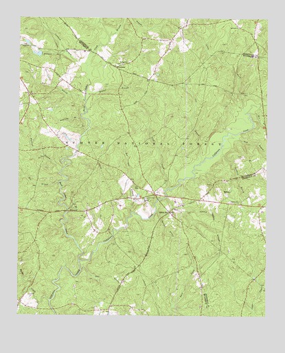
Winterseat, SC USGS Topographic Map
Click on map above to begin viewing in our Map Viewer.

This topographic map contains these locations and features:
Feature Name Type Latitude Longitude GNIS ID View Map
Bee Tree BranchStreamN33.9182°W82.1932°1229391View Map
Bethany CemeteryCemeteryN33.9237°W82.1868°1229172View Map
Bethany ChurchChurchN33.9237°W82.1865°1246761View Map
Bethany School (historical)SchoolN33.9240°W82.1868°1229174View Map
Big BranchStreamN33.9654°W82.2171°1229412View Map
Blue BranchStreamN33.9315°W82.2298°1229433View Map
Blue Branch School (historical)SchoolN33.9168°W82.2354°1229176View Map
Bracknell BranchStreamN33.9354°W82.2287°1229452View Map
Brissey BranchStreamN33.9926°W82.2046°1229455View Map
Buncombe BranchStreamN33.9582°W82.2182°1229486View Map
Calabash BranchStreamN33.9796°W82.2160°1229498View Map
Canfield CemeteryCemeteryN33.8835°W82.2448°1229520View Map
Cow BranchStreamN33.9398°W82.1579°1229597View Map
Cuffytown CreekStreamN33.8976°W82.2193°1247460View Map
Deal BranchStreamN33.8943°W82.2179°1229627View Map
Doctors BranchStreamN33.9190°W82.1804°1229642View Map
Dornville (historical)Populated PlaceN33.9187°W82.2410°1241318View Map
Flat Rock School (historical)SchoolN33.9293°W82.1432°1229003View Map
Goatneck BranchStreamN33.9857°W82.2271°1229736View Map
Hard Labor CreekStreamN33.8979°W82.2193°1245903View Map
Hibbler BranchStreamN33.9651°W82.2160°1229794View Map
Hibler School (historical)SchoolN33.9782°W82.1551°1229204View Map
Highway Holy ChurchChurchN33.9273°W82.1437°1229797View Map
Hill BranchStreamN33.9246°W82.1757°1229798View Map
Liberty HillPopulated PlaceN33.9187°W82.1737°1246357View Map
Liberty Hill Lookout TowerTowerN33.9229°W82.1429°1242436View Map
Lick CreekStreamN33.9287°W82.1743°1246366View Map
Little CreekStreamN33.9604°W82.1357°1246394View Map
Lyon School (historical)SchoolN33.9573°W82.1954°1229223View Map
McCormick Correctional Institution InfirmaryHospitalN33.9290°W82.2499°2640038View Map
McCormick DivisionCivilN33.9230°W82.2473°1938344View Map
Mill BranchStreamN33.9607°W82.1340°1230005View Map
Mount Harmony ChurchChurchN33.9810°W82.1987°1249575View Map
Oak Grove ChurchChurchN33.9965°W82.1398°1230117View Map
Old Bethany CemeteryCemeteryN33.9246°W82.1860°1229245View Map
Old Whitetown Church (historical)ChurchN33.8790°W82.1998°1229246View Map
Piney Grove School (historical)SchoolN33.9057°W82.1635°1229258View Map
Robinson Church (historical)ChurchN33.9612°W82.2451°1229265View Map
Robinson School (historical)SchoolN33.9660°W82.2451°1229266View Map
Rock Grove School (historical)SchoolN33.8815°W82.1273°1229000View Map
Rocky CreekStreamN33.8812°W82.2340°1230251View Map
Sand BranchStreamN33.9510°W82.1446°1230290View Map
Sand Hill School (historical)SchoolN33.9323°W82.1462°1229275View Map
Sandhill BranchStreamN33.9432°W82.1498°1230293View Map
Shinburg Mill (historical)LocaleN33.9243°W82.1804°1252058View Map
South Carolina Noname 35008 D-0637 DamDamN33.9851°W82.2382°1238856View Map
Tranquil ChurchChurchN33.9882°W82.2454°1251194View Map
West Pond School (historical)SchoolN33.9215°W82.1385°1229002View Map
Whites Cross Roads (historical)Populated PlaceN33.9237°W82.1585°1229278View Map
Winn Store (historical)LocaleN33.8907°W82.1307°1229001View Map
WinterseatPopulated PlaceN33.9796°W82.2018°1251478View Map
Zion ChapelChurchN33.9296°W82.1904°1251542View Map
Zion Chapel School (historical)SchoolN33.9293°W82.1904°1229289View Map

Note: Coordinates in the location and feature list above are referenced to NAD83 datum.


Copyright (C) 2008-2024 Ryan Niemi / Sunset Dynamics ... All Rights Reserved