TopoQuest Logo
Do you find TopoQuest useful?
Help keep TopoQuest running and adding new maps/features by donating!
Bitcoin:  19c7KJd3qBynnjoSw5npx9KScwjBe4ifkT
Litecoin:  LXs6TkuXGGXo1vDsWCkWVdjQX94eUKd6ui
Home View Maps Find Maps Find Places Resources & Links


Vernon, Utah Topographic Map

USGS Map Title: Vernon, UT
USGS Map MRC: 40112A4
DRG (GeoTIFF) Download: o40112a4.tif


Neighboring USGS Topographic Map Quads:


  Onaqui Mountains South, UT  
40112B5
 

  Faust, UT  
40112B4
 

  Vernon NE, UT  
40112B3
 

  Lookout Pass, UT  
40112A5
 

  Vernon, UT  
40112A4
 

  Lofgreen, UT  
40112A3
 

  Erickson Knoll, UT  
39112H5
 

  Dutch Peak, UT  
39112H4
 

  Sabie Mountain, UT  
39112H3


Map MRC Location:

N41°
W113°
N41°
W112°
H8 H7 H6 H5 H4 H3 H2 H1
G8 G7 G6 G5 G4 G3 G2 G1
F8 F7 F6 F5 F4 F3 F2 F1
E8 E7 E6 E5 E4 E3 E2 E1
D8 D7 D6 D5 D4 D3 D2 D1
C8 C7 C6 C5 C4 C3 C2 C1
B8 B7 B6 B5 B4 B3 B2 B1
A8 A7 A6 A5 A4 A3 A2 A1
N40°
W113°
N40°
W112°

Vernon, UT USGS 1:24K Topographic Map Preview:
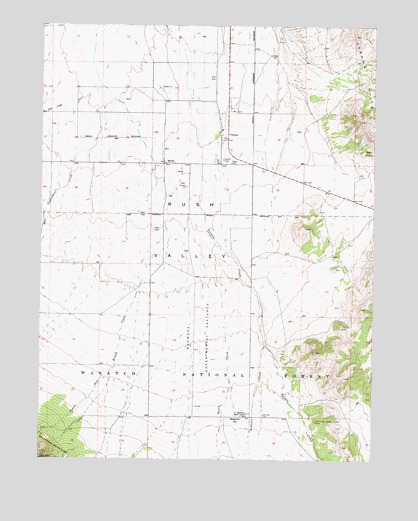
Vernon, UT USGS Topographic Map
Click on map above to begin viewing in our Map Viewer.

This topographic map contains these locations and features:
Feature Name Type Latitude Longitude GNIS ID View Map
BenmoreLocaleN40.0124°W112.4216°1438596View Map
Benmore Experiment StationLocaleN40.0124°W112.4236°1451191View Map
Benmore Experimental PasturesFlatN40.0363°W112.4413°1438597View Map
Benmore Guard StationLocaleN40.0133°W112.4225°1438598View Map
Bennion CreekStreamN40.0341°W112.4166°1438604View Map
Bureau Land Management Fire Station West Desert Vernon StationBuildingN40.1016°W112.4281°2768437View Map
Chief Green Jacket GraveCemeteryN40.0111°W112.3973°1439684View Map
Dutch CreekStreamN40.0619°W112.4355°1440736View Map
East Government CreekStreamN40.0877°W112.4883°1440826View Map
North Oak Brush CreekStreamN40.0591°W112.4586°1443961View Map
Red Pine CreekStreamN40.1013°W112.4933°1444824View Map
The Church of Jesus Christ of Latter Day SaintsChurchN40.0947°W112.4333°1449652View Map
Town of VernonCivilN40.0956°W112.4458°2413430View Map
VernonPopulated PlaceN40.0922°W112.4336°1446932View Map
Vernon Airstrip (historical)AirportN40.1041°W112.4216°1447601View Map
Vernon CemeteryCemeteryN40.0863°W112.4324°1446933View Map
Vernon CreekStreamN40.0805°W112.4408°1446934View Map
Vernon Elementary SchoolSchoolN40.0935°W112.4330°1449144View Map
Vernon Fire DepartmentBuildingN40.0869°W112.4333°2627240View Map
Vernon Post OfficePost OfficeN40.0927°W112.4332°2769083View Map

Note: Coordinates in the location and feature list above are referenced to NAD83 datum.


Copyright (C) 2008-2025 Ryan Niemi / Sunset Dynamics ... All Rights Reserved