TopoQuest Logo
Do you find TopoQuest useful?
Help keep TopoQuest running and adding new maps/features by donating!
Bitcoin:  19c7KJd3qBynnjoSw5npx9KScwjBe4ifkT
Litecoin:  LXs6TkuXGGXo1vDsWCkWVdjQX94eUKd6ui
Home View Maps Find Maps Find Places Resources & Links


Vevay South, Indiana Topographic Map

USGS Map Title: Vevay South, IN
USGS Map MRC: 38085F1
DRG (GeoTIFF) Download: o38085f1.tif


Neighboring USGS Topographic Map Quads:


  Bennington, IN  
38085G2
 

  Vevay North, IN  
38085G1
 

  Florence, IN  
38084G8
 

  Carrollton, KY  
38085F2
 

  Vevay South, IN  
38085F1
 

  Sanders, KY  
38084F8
 

  Campbellsburg, KY  
38085E2
 

  Worthville, KY  
38085E1
 

  New Liberty, KY  
38084E8


Map MRC Location:

N39°
W86°
N39°
W85°
H8 H7 H6 H5 H4 H3 H2 H1
G8 G7 G6 G5 G4 G3 G2 G1
F8 F7 F6 F5 F4 F3 F2 F1
E8 E7 E6 E5 E4 E3 E2 E1
D8 D7 D6 D5 D4 D3 D2 D1
C8 C7 C6 C5 C4 C3 C2 C1
B8 B7 B6 B5 B4 B3 B2 B1
A8 A7 A6 A5 A4 A3 A2 A1
N38°
W86°
N38°
W85°

Vevay South, IN USGS 1:24K Topographic Map Preview:
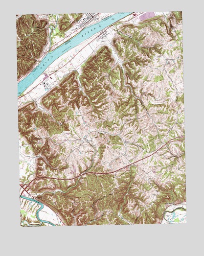
Vevay South, IN USGS Topographic Map
Click on map above to begin viewing in our Map Viewer.

This topographic map contains these locations and features:
Feature Name Type Latitude Longitude GNIS ID View Map
Black Rock CreekStreamN38.7431°W85.0540°487362View Map
Buffalo School (historical)SchoolN38.6256°W85.0417°2565034View Map
Carroll CountyCivilN38.6679°W85.1236°516867View Map
Carrollton DivisionCivilN38.6774°W85.0575°1936921View Map
City of GhentCivilN38.7340°W85.0614°2403694View Map
Cox School (historical)SchoolN38.6723°W85.1233°2565039View Map
Craig BarBarN38.7042°W85.1247°507325View Map
Eagle StationLocaleN38.6362°W85.0100°491412View Map
Eagle Station Post Office (historical)Post OfficeN38.6369°W85.0034°2565041View Map
EasterdayPopulated PlaceN38.6756°W85.0744°507902View Map
Easterday Post Office (historical)Post OfficeN38.6748°W85.0739°2565042View Map
Fourmile CreekStreamN38.7028°W85.1230°492387View Map
GhentPopulated PlaceN38.7376°W85.0583°492798View Map
Ghent 2nd Baptist CemeteryCemeteryN38.7339°W85.0622°1901068View Map
Ghent CemeteryCemeteryN38.7339°W85.0571°2565046View Map
Ghent Consolidated CemeteryCemeteryN38.7342°W85.0566°1901066View Map
Ghent Fire Department Station 1BuildingN38.7379°W85.0599°2636859View Map
Ghent IOOF CemeteryCemeteryN38.7340°W85.0568°1901116View Map
Ghent's Old Black CemeteryCemeteryN38.7334°W85.0561°1901069View Map
Goose CreekStreamN38.6256°W85.0991°493016View Map
Grass Hills Post Office (historical)Post OfficeN38.6857°W85.0055°2565048View Map
Indian CreekStreamN38.7267°W85.1016°436751View Map
Jefferson-Craig Elementary SchoolSchoolN38.7417°W85.0766°447085View Map
Johnsons Mill (historical)LocaleN38.6373°W85.0025°2565022View Map
LangstaffPopulated PlaceN38.6415°W85.1133°508426View Map
Lees CreekStreamN38.6256°W85.1225°496182View Map
Lower Whites Run Baptist Church (historical)ChurchN38.6753°W85.0744°2565030View Map
Lower Whites Run Baptist Church CemeteryCemeteryN38.6757°W85.0744°2565054View Map
Marvin Chapel Methodist Church (historical)ChurchN38.6673°W85.0494°2565055View Map
Masonic CemeteryCemeteryN38.7340°W85.0569°1901115View Map
McCools CreekStreamN38.7148°W85.1066°497800View Map
McCools Creek Baptist Church (historical)ChurchN38.7351°W85.0562°2565056View Map
Mennets RunStreamN38.7212°W85.1075°439012View Map
Mill CreekStreamN38.6273°W85.1086°498266View Map
Potato Bug HillSummitN38.7412°W85.1127°441492View Map
Rockville (historical)Populated PlaceN38.6996°W85.0349°2565064View Map
School Number Eight (historical)SchoolN38.6761°W85.0812°2565066View Map
Scott Number 1 CemeteryCemeteryN38.7342°W85.0566°1901114View Map
Snell LakeLakeN38.7201°W85.0121°503849View Map
South Fork McCools CreekStreamN38.7167°W85.0802°503935View Map
Stafford CemeteryCemeteryN38.6423°W85.0224°504222View Map
Switzerland County CourthouseBuildingN38.7469°W85.0689°2559502View Map
Switzerland County Junior-Senior High SchoolSchoolN38.7409°W85.0794°447084View Map
Switzerland County Sheriff's OfficeBuildingN38.7478°W85.0694°2758167View Map
Tandy Post Office (historical)Post OfficeN38.6995°W85.0360°2565070View Map
Town of VevayCivilN38.7427°W85.0782°2397716View Map
VevayPopulated PlaceN38.7478°W85.0672°445270View Map
Vevay Police DepartmentBuildingN38.7474°W85.0666°2758481View Map
Whiskey HollowValleyN38.7244°W85.1133°445908View Map
Whitehead CemeteryCemeteryN38.6756°W85.0744°1901139View Map
Whites RunStreamN38.6412°W85.1155°506675View Map
Whites Run ChurchChurchN38.6728°W85.0441°506677View Map
Whites Run School (historical)SchoolN38.6520°W85.0778°2565072View Map

Note: Coordinates in the location and feature list above are referenced to NAD83 datum.


Copyright (C) 2008-2024 Ryan Niemi / Sunset Dynamics ... All Rights Reserved