TopoQuest Logo
Do you find TopoQuest useful?
Help keep TopoQuest running and adding new maps/features by donating!
Bitcoin:  19c7KJd3qBynnjoSw5npx9KScwjBe4ifkT
Litecoin:  LXs6TkuXGGXo1vDsWCkWVdjQX94eUKd6ui
Home View Maps Find Maps Find Places Resources & Links


Villanueva, New Mexico Topographic Map

USGS Map Title: Villanueva, NM
USGS Map MRC: 35105C3
DRG (GeoTIFF) Download: o35105c3.tif


Neighboring USGS Topographic Map Quads:


  San Jose, NM  
35105D4
 

  Tecolote, NM  
35105D3
 

  Los Montoyas, NM  
35105D2
 

  Sena, NM  
35105C4
 

  Villanueva, NM  
35105C3
 

  Apache Springs, NM  
35105C2
 

  Aurora, NM  
35105B4
 

  San Juan, NM  
35105B3
 

  Anton Chico, NM  
35105B2


Map MRC Location:

N36°
W106°
N36°
W105°
H8 H7 H6 H5 H4 H3 H2 H1
G8 G7 G6 G5 G4 G3 G2 G1
F8 F7 F6 F5 F4 F3 F2 F1
E8 E7 E6 E5 E4 E3 E2 E1
D8 D7 D6 D5 D4 D3 D2 D1
C8 C7 C6 C5 C4 C3 C2 C1
B8 B7 B6 B5 B4 B3 B2 B1
A8 A7 A6 A5 A4 A3 A2 A1
N35°
W106°
N35°
W105°

Villanueva, NM USGS 1:24K Topographic Map Preview:
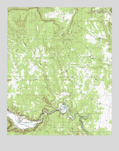
Villanueva, NM USGS Topographic Map
Click on map above to begin viewing in our Map Viewer.

This topographic map contains these locations and features:
Feature Name Type Latitude Longitude GNIS ID View Map
Cattleguard TankReservoirN35.3487°W105.3113°904839View Map
Cerritos TankReservoirN35.3127°W105.3065°904925View Map
Dos LagunasLakeN35.3057°W105.3423°936514View Map
El Caņon de PenaValleyN35.2759°W105.3164°906035View Map
El Caņon del Palo AmarilloValleyN35.2773°W105.3000°906036View Map
El CerritoPopulated PlaceN35.2756°W105.3120°915921View Map
El Cerrito Post OfficePost OfficeN35.2756°W105.3120°938156View Map
El Pueblo WellWellN35.3275°W105.2747°912558View Map
Head Quarters TankReservoirN35.3252°W105.2714°912559View Map
KBAC-FM (Las Vegas)TowerN35.3723°W105.3678°938674View Map
Lagunita SpringsSpringN35.3724°W105.2593°907815View Map
Leguino TankReservoirN35.3445°W105.2642°907934View Map
Middle TankReservoirN35.3192°W105.2528°908718View Map
Quintana Forest Service Station (historical)LocaleN35.3000°W105.2925°936516View Map
Road TankReservoirN35.3487°W105.3120°2038652View Map
San Miguel Del Bado Tract Number 1CivilN35.2748°W105.3081°910679View Map
Sombodoro MesaSummitN35.3512°W105.3014°911204View Map
Valley Elementary SchoolSchoolN35.3275°W105.2747°933904View Map
Valley Junior High SchoolSchoolN35.3275°W105.2747°934207View Map
VillanuevaPopulated PlaceN35.2667°W105.3608°915912View Map
Villanueva Census Designated PlaceCensusN35.2659°W105.3602°2584233View Map
Villanueva Northside DitchCanalN35.2628°W105.3620°912112View Map
Villanueva Post OfficePost OfficeN35.2667°W105.3608°938492View Map
Villanueva Southside DitchCanalN35.2595°W105.3647°912113View Map
Villanueva State ParkParkN35.2570°W105.3672°912560View Map
Villanueva Weather StationLocaleN35.2667°W105.3608°931769View Map

Note: Coordinates in the location and feature list above are referenced to NAD83 datum.


Copyright (C) 2008-2025 Ryan Niemi / Sunset Dynamics ... All Rights Reserved