TopoQuest Logo
Do you find TopoQuest useful?
Help keep TopoQuest running and adding new maps/features by donating!
Bitcoin:  19c7KJd3qBynnjoSw5npx9KScwjBe4ifkT
Litecoin:  LXs6TkuXGGXo1vDsWCkWVdjQX94eUKd6ui
Home View Maps Find Maps Find Places Resources & Links


Waddell, Arizona Topographic Map

USGS Map Title: Waddell, AZ
USGS Map MRC: 33112E4
DRG (GeoTIFF) Download: o33112e4.tif


Neighboring USGS Topographic Map Quads:


  White Tank Mountains NE, AZ  
33112F5
 

  McMicken Dam, AZ  
33112F4
 

  Calderwood Butte, AZ  
33112F3
 

  White Tank Mountains, AZ  
33112E5
 

  Waddell, AZ  
33112E4
 

  El Mirage, AZ  
33112E3
 

  Valencia, AZ  
33112D5
 

  Perryville, AZ  
33112D4
 

  Tolleson, AZ  
33112D3


Map MRC Location:

N34°
W113°
N34°
W112°
H8 H7 H6 H5 H4 H3 H2 H1
G8 G7 G6 G5 G4 G3 G2 G1
F8 F7 F6 F5 F4 F3 F2 F1
E8 E7 E6 E5 E4 E3 E2 E1
D8 D7 D6 D5 D4 D3 D2 D1
C8 C7 C6 C5 C4 C3 C2 C1
B8 B7 B6 B5 B4 B3 B2 B1
A8 A7 A6 A5 A4 A3 A2 A1
N33°
W113°
N33°
W112°

Waddell, AZ USGS 1:24K Topographic Map Preview:
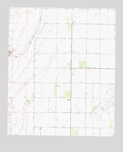
Waddell, AZ USGS Topographic Map
Click on map above to begin viewing in our Map Viewer.

This topographic map contains these locations and features:
Feature Name Type Latitude Longitude GNIS ID View Map
Ashton Ranch Elementary SchoolSchoolN33.6165°W112.3805°2517839View Map
Beardsley Canal WashArroyoN33.5350°W112.4716°1699836View Map
Bedrock WashArroyoN33.5273°W112.4807°1699835View Map
Buckeye Valley Fire District Station 321BuildingN33.5044°W112.4650°2775457View Map
Cholla WashArroyoN33.5581°W112.4718°1699832View Map
Citrus ParkPopulated PlaceN33.5487°W112.4443°2964View Map
Citrus ParkLocaleN33.5350°W112.4271°2965View Map
Citrus Park Census Designated PlaceCensusN33.5303°W112.4439°2582757View Map
Cotton Lane Community ChurchChurchN33.5273°W112.4277°2670819View Map
Countryside Elementary SchoolSchoolN33.6214°W112.3883°2517838View Map
Coyner AirstripAirportN33.5077°W112.4724°45388View Map
Detention BasinBasinN33.5323°W112.4774°3881View Map
Diversion Dike WashArroyoN33.5150°W112.4966°1699830View Map
Falcon Golf ClubLocaleN33.5150°W112.3859°2670463View Map
FennemorePopulated PlaceN33.5703°W112.4274°24414View Map
Fennemore Railroad StationBuildingN33.5670°W112.4271°14462View Map
Luke Air Force BaseAirportN33.5334°W112.3791°2651017View Map
Luke Golf CourseLocaleN33.5551°W112.3887°2670577View Map
Marley Park Elementary SchoolSchoolN33.6041°W112.3831°2517841View Map
Mountain View SchoolSchoolN33.5774°W112.4504°2517847View Map
North Fork Bedrock WashArroyoN33.5353°W112.4941°1699826View Map
Parkway Christian ChurchChurchN33.5862°W112.3784°2671688View Map
Perryville Road WashArroyoN33.5084°W112.4557°1699822View Map
Rancho Gabriela Elementary SchoolSchoolN33.5876°W112.3880°2517843View Map
Sierra Montana Recreation CenterBuildingN33.6199°W112.4422°2669896View Map
Sonoran Heights Elementary SchoolSchoolN33.5878°W112.4004°2517844View Map
Sunset Hills Elementary SchoolSchoolN33.6199°W112.4421°2517842View Map
Surprise Fire Department Station 303BuildingN33.6247°W112.4278°2672592View Map
Surprise Fire Department Station 305BuildingN33.6246°W112.3847°2672594View Map
Surprise Fire Department Station 307BuildingN33.5946°W112.4071°2672596View Map
The Church of Jesus Christ of Latter Day SaintsChurchN33.6195°W112.4386°2671361View Map
The Church of Jesus Christ of Latter Day SaintsChurchN33.6200°W112.4103°2671362View Map
The Church of Jesus Christ of Latter Day SaintsChurchN33.5960°W112.4014°2671370View Map
WaddellPopulated PlaceN33.6114°W112.4271°24677View Map
Waddell Post OfficePost OfficeN33.5376°W112.4274°2669936View Map
Waddell SubstationLocaleN33.5959°W112.4257°15196View Map
Waterfall WashArroyoN33.5667°W112.4721°1699819View Map
WaynePopulated PlaceN33.5662°W112.4096°24680View Map
White Tank Number Three WashArroyoN33.5306°W112.4743°1699817View Map
Wildlife World ZooLocaleN33.5496°W112.4145°2669541View Map

Note: Coordinates in the location and feature list above are referenced to NAD83 datum.


Copyright (C) 2008-2024 Ryan Niemi / Sunset Dynamics ... All Rights Reserved