TopoQuest Logo
Do you find TopoQuest useful?
Help keep TopoQuest running and adding new maps/features by donating!
Bitcoin:  19c7KJd3qBynnjoSw5npx9KScwjBe4ifkT
Litecoin:  LXs6TkuXGGXo1vDsWCkWVdjQX94eUKd6ui
Home View Maps Find Maps Find Places Resources & Links


Valencia, Arizona Topographic Map

USGS Map Title: Valencia, AZ
USGS Map MRC: 33112D5
DRG (GeoTIFF) Download: o33112d5.tif


Neighboring USGS Topographic Map Quads:


  Wagner Wash Well, AZ  
33112E6
 

  White Tank Mountains, AZ  
33112E5
 

  Waddell, AZ  
33112E4
 

  Buckeye NW, AZ  
33112D6
 

  Valencia, AZ  
33112D5
 

  Perryville, AZ  
33112D4
 

  Hassayampa, AZ  
33112C6
 

  Buckeye, AZ  
33112C5
 

  Avondale SW, AZ  
33112C4


Map MRC Location:

N34°
W113°
N34°
W112°
H8 H7 H6 H5 H4 H3 H2 H1
G8 G7 G6 G5 G4 G3 G2 G1
F8 F7 F6 F5 F4 F3 F2 F1
E8 E7 E6 E5 E4 E3 E2 E1
D8 D7 D6 D5 D4 D3 D2 D1
C8 C7 C6 C5 C4 C3 C2 C1
B8 B7 B6 B5 B4 B3 B2 B1
A8 A7 A6 A5 A4 A3 A2 A1
N33°
W113°
N33°
W112°

Valencia, AZ USGS 1:24K Topographic Map Preview:
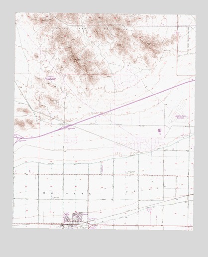
Valencia, AZ USGS Topographic Map
Click on map above to begin viewing in our Map Viewer.

This topographic map contains these locations and features:
Feature Name Type Latitude Longitude GNIS ID View Map
Bales Elementary SchoolSchoolN33.3863°W112.5965°2466632View Map
Buckeye CanalCanalN33.3853°W112.5399°2082View Map
Buckeye Fire Department Station 702 SundanceBuildingN33.4291°W112.5384°2672426View Map
Buckeye Fire Department Station 703 VerradoBuildingN33.4757°W112.5045°2672448View Map
Buckeye Fire Department Station 706BuildingN33.4230°W112.6067°2672671View Map
Buckeye FRS Dam Number ThreeDamN33.4600°W112.5224°14248View Map
Buckeye FRS Dam Number TwoDamN33.4384°W112.5891°14249View Map
Buckeye SubstationLocaleN33.4370°W112.5924°14254View Map
Buckeye Union High SchoolSchoolN33.3751°W112.5770°14256View Map
Buckeye Valley Fire District Station 327BuildingN33.4209°W112.5396°2672674View Map
Buena Vista Mobile Home ParkPopulated PlaceN33.4283°W112.5762°2670061View Map
Country Home Mobile VillagePopulated PlaceN33.3788°W112.5600°2669756View Map
Freedom Elementary SchoolSchoolN33.4321°W112.5268°2517855View Map
Grace Fellowship ChurchChurchN33.3876°W112.5921°2671101View Map
Inca Elementary SchoolSchoolN33.4274°W112.5586°2517834View Map
Interchange One Hundred FourteenCrossingN33.4334°W112.5910°14611View Map
Leaf Verde Recreational Vehicle ResortLocaleN33.4331°W112.5759°2669882View Map
Liberty SubstationLocaleN33.4125°W112.5002°14678View Map
Louis B Hazelton Memorial CemeteryCemeteryN33.4076°W112.5466°7426View Map
Raven Golf Club at VerradoLocaleN33.4931°W112.5174°2670582View Map
Steven R Jasinski Elementary SchoolSchoolN33.4075°W112.5818°2517831View Map
Sundance Elementary SchoolSchoolN33.4386°W112.5629°2517832View Map
Sundance Golf ClubLocaleN33.4405°W112.5412°2670125View Map
ValenciaPopulated PlaceN33.3795°W112.5841°13156View Map
Verrado Elementary SchoolSchoolN33.4976°W112.5072°2517858View Map
Verrado Middle SchoolSchoolN33.4964°W112.5086°2467334View Map
West Park Elementary SchoolSchoolN33.4221°W112.6063°2517833View Map
White Tanks Proving GroundsLocaleN33.4989°W112.5002°15223View Map
Youngker High SchoolSchoolN33.4186°W112.5748°2517837View Map

Note: Coordinates in the location and feature list above are referenced to NAD83 datum.


Copyright (C) 2008-2025 Ryan Niemi / Sunset Dynamics ... All Rights Reserved