TopoQuest Logo
Do you find TopoQuest useful?
Help keep TopoQuest running and adding new maps/features by donating!
Bitcoin:  19c7KJd3qBynnjoSw5npx9KScwjBe4ifkT
Litecoin:  LXs6TkuXGGXo1vDsWCkWVdjQX94eUKd6ui
Home View Maps Find Maps Find Places Resources & Links


Wadsworth, Nevada Topographic Map

USGS Map Title: Wadsworth, NV
USGS Map MRC: 39119F3
DRG (GeoTIFF) Download: o39119f3.tif


Neighboring USGS Topographic Map Quads:


  Pah Rah Mountain, NV  
39119G4
 

  Nixon, NV  
39119G3
 

  Juniper Peak, NV  
39119G2
 

  Olinghouse, NV  
39119F4
 

  Wadsworth, NV  
39119F3
 

  Two Tips, NV  
39119F2
 

  Derby Dam, NV  
39119E4
 

  Fernley West, NV  
39119E3
 

  Fernley East, NV  
39119E2


Map MRC Location:

N40°
W120°
N40°
W119°
H8 H7 H6 H5 H4 H3 H2 H1
G8 G7 G6 G5 G4 G3 G2 G1
F8 F7 F6 F5 F4 F3 F2 F1
E8 E7 E6 E5 E4 E3 E2 E1
D8 D7 D6 D5 D4 D3 D2 D1
C8 C7 C6 C5 C4 C3 C2 C1
B8 B7 B6 B5 B4 B3 B2 B1
A8 A7 A6 A5 A4 A3 A2 A1
N39°
W120°
N39°
W119°

Wadsworth, NV USGS 1:24K Topographic Map Preview:
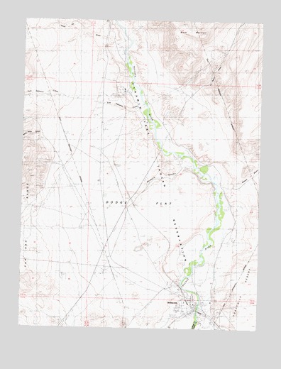
Wadsworth, NV USGS Topographic Map
Click on map above to begin viewing in our Map Viewer.

This topographic map contains these locations and features:
Feature Name Type Latitude Longitude GNIS ID View Map
CAA StationLocaleN39.7071°W119.3338°848346View Map
Dead Ox WashStreamN39.7382°W119.3232°839948View Map
Diabase HillsRangeN39.7399°W119.2921°848458View Map
DodgePopulated PlaceN39.6707°W119.3121°856016View Map
Dodge FlatFlatN39.6741°W119.3127°840075View Map
Fort Defiance CreekStreamN39.7166°W119.3129°840530View Map
Gardella CanyonValleyN39.6932°W119.2916°840604View Map
HerstinLocaleN39.6596°W119.2979°856783View Map
Hill Ranch CanyonValleyN39.7227°W119.2843°841003View Map
Hills (historical)LocaleN39.7080°W119.3032°847564View Map
James RanchLocaleN39.6430°W119.2857°847571View Map
Lower Crossing (historical)CrossingN39.6321°W119.2818°847643View Map
Millers CreekStreamN39.6491°W119.3613°848452View Map
Natchez Elementary SchoolSchoolN39.6357°W119.2896°847644View Map
Red White and Blue MountainSummitN39.6266°W119.3213°848454View Map
Thomas RanchLocaleN39.6907°W119.2902°847572View Map
Tiger CanyonValleyN39.6763°W119.3693°844315View Map
WadsworthPopulated PlaceN39.6338°W119.2854°844607View Map
Wadsworth Airport (historical)AirportN39.6763°W119.3163°855159View Map
Wadsworth Census Designated PlaceCensusN39.6321°W119.2901°2409520View Map
Wadsworth Post OfficePost OfficeN39.6320°W119.2866°864706View Map
White Horse CanyonValleyN39.7032°W119.3660°848676View Map
Windmill CanyonValleyN39.6838°W119.2704°850610View Map

Note: Coordinates in the location and feature list above are referenced to NAD83 datum.


Copyright (C) 2008-2025 Ryan Niemi / Sunset Dynamics ... All Rights Reserved