TopoQuest Logo
Do you find TopoQuest useful?
Help keep TopoQuest running and adding new maps/features by donating!
Bitcoin:  19c7KJd3qBynnjoSw5npx9KScwjBe4ifkT
Litecoin:  LXs6TkuXGGXo1vDsWCkWVdjQX94eUKd6ui
Home View Maps Find Maps Find Places Resources & Links


Wakarusa, Indiana Topographic Map

USGS Map Title: Wakarusa, IN
USGS Map MRC: 41086E1
DRG (GeoTIFF) Download: o41086e1.tif


Neighboring USGS Topographic Map Quads:


  South Bend East, IN  
41086F2
 

  Osceola, IN  
41086F1
 

  Elkhart, IN  
41085F8
 

  Wyatt, IN  
41086E2
 

  Wakarusa, IN  
41086E1
 

  Foraker, IN  
41085E8
 

  Bremen, IN  
41086D2
 

  Nappanee West, IN  
41086D1
 

  Nappanee East, IN  
41085D8


Map MRC Location:

N42°
W87°
N42°
W86°
H8 H7 H6 H5 H4 H3 H2 H1
G8 G7 G6 G5 G4 G3 G2 G1
F8 F7 F6 F5 F4 F3 F2 F1
E8 E7 E6 E5 E4 E3 E2 E1
D8 D7 D6 D5 D4 D3 D2 D1
C8 C7 C6 C5 C4 C3 C2 C1
B8 B7 B6 B5 B4 B3 B2 B1
A8 A7 A6 A5 A4 A3 A2 A1
N41°
W87°
N41°
W86°

Wakarusa, IN USGS 1:24K Topographic Map Preview:
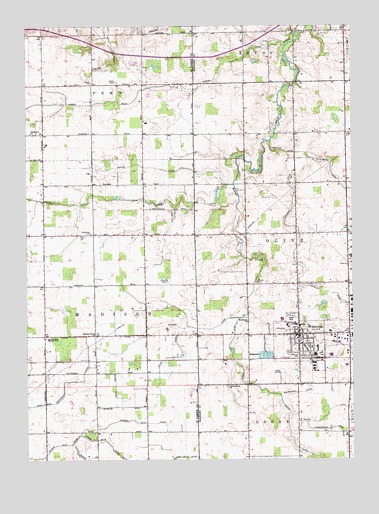
Wakarusa, IN USGS Topographic Map
Click on map above to begin viewing in our Map Viewer.

This topographic map contains these locations and features:
Feature Name Type Latitude Longitude GNIS ID View Map
Barkey DitchCanalN41.5842°W86.0764°452535View Map
Billman DitchCanalN41.5367°W86.0611°452548View Map
Christophel DitchCanalN41.5112°W86.0181°432504View Map
Eby FieldAirportN41.5642°W86.0538°2677067View Map
Holdeman ChurchChurchN41.5398°W86.0406°436307View Map
Holderman DitchCanalN41.5187°W86.0286°436311View Map
Lateral Number Fifteen DitchCanalN41.5175°W86.1122°452663View Map
Lateral Number FiveCanalN41.5045°W86.1097°452664View Map
Little Bingo CreekCanalN41.5098°W86.0244°446214View Map
Louck DitchCanalN41.5295°W86.0703°452673View Map
Madison Union ChurchChurchN41.5359°W86.0983°452677View Map
Miller DitchCanalN41.5150°W86.0072°439219View Map
North Union ChurchChurchN41.5214°W86.0486°440307View Map
Nunemaker DitchCanalN41.5889°W86.0222°440370View Map
Olive ChurchChurchN41.6078°W86.0228°440648View Map
Phelps FarmsLocaleN41.5028°W86.1172°2709052View Map
Pittman Gordon DitchCanalN41.5045°W86.1050°452736View Map
Pletcher CemeteryCemeteryN41.5299°W86.0211°441358View Map
Resthaven CemeteryCemeteryN41.5653°W86.0999°452749View Map
Rogers DitchCanalN41.6028°W86.0981°452752View Map
Roner SchoolSchoolN41.6087°W86.0997°452754View Map
Shutts CemeteryCemeteryN41.5512°W86.0369°443473View Map
Tamarack ChurchChurchN41.5939°W86.1236°452815View Map
Town of WakarusaCivilN41.5336°W86.0139°2397717View Map
Township DitchCanalN41.5917°W86.0311°444840View Map
Township of OliveCivilN41.5651°W86.0310°453687View Map
WakarusaPopulated PlaceN41.5362°W86.0208°452499View Map
Wakarusa Ambulance DepartmentBuildingN41.5359°W86.0171°2719279View Map
Wakarusa Elementary and Middle SchoolSchoolN41.5392°W86.0214°446606View Map
Wakarusa Fire DepartmentBuildingN41.5358°W86.0170°2626095View Map
Wakarusa Police DepartmentBuildingN41.5356°W86.0174°2758058View Map
Werntz DitchCanalN41.5431°W86.0403°445685View Map
Zion ChurchChurchN41.5648°W86.1044°452847View Map

Note: Coordinates in the location and feature list above are referenced to NAD83 datum.


Copyright (C) 2008-2025 Ryan Niemi / Sunset Dynamics ... All Rights Reserved